Property Record
21 Howe St, Methuen, MA 01844
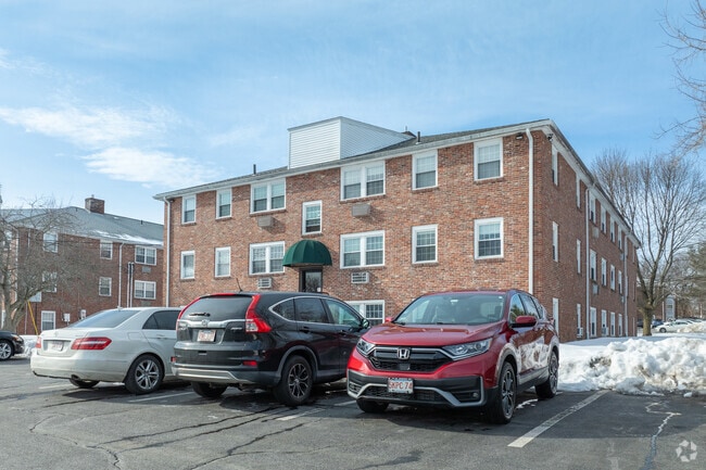

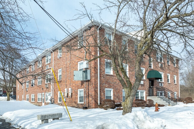
Property Detail
21 Howe St
AMES-000076-000000-000048
ESSEX
Apartment
Massachusetts
MA
701
B and X Area of moderate flood hazard, usually the area between the limits of the 100-year and 500-year floods.
4.74 AC
2025
Methuen
2025
Boston
252602
Boston-Cambridge-Newton, MA-NH
NEARBY LISTINGS FOR SALE OR LEASE
DEMOGRAPHICS near 21 Howe St
1 mile
3 mile
5 mile
2025 Total Population
6,915
104,955
218,834
2030 Population
7,165
105,614
221,535
Pop Growth 2025-2030
+ 3.62%
+ 0.63%
+ 1.23%
Average Age
42
39
40
2025 Total Households
2,511
36,587
79,660
HH Growth 2025-2030
+ 3.31%
+ 0.76%
+ 1.41%
Median Household Inc
$118,818
$73,045
$80,821
Avg Household Size
2.60
2.70
2.60
2025 Avg HH Vehicles
2.00
2.00
2.00
Median Home Value
$506,091
$476,979
$478,254
Median Year Built
1976
1963
1965
Nearby Places
Map Layers
Map Styles
 Street
 Aerial
Transit
 Traffic
 Biking
Places
Listings with unknown addresses are not visible on the map
- Restaurants
- Banks
- Shops
- Fitness
- Groceries
PUBLIC TRANSPORTATION
COMMUTER RAIL
Lawrence (Haverhill Line - Massachusetts Bay Transportation Authority Commuter Rail (Purple Line))
Drive
Walk
Distance
Lawrence (Haverhill Line - Massachusetts Bay Transportation Authority Commuter Rail (Purple Line))
7 min
3.4 mi
Bradford (Haverhill Line - Massachusetts Bay Transportation Authority Commuter Rail (Purple Line))
Drive
Walk
Distance
Bradford (Haverhill Line - Massachusetts Bay Transportation Authority Commuter Rail (Purple Line))
12 min
7.4 mi
AIRPORT
Manchester Boston Regional
Drive
Walk
Distance
Manchester Boston Regional
38 min
24.6 mi
General Edward Lawrence Logan International
Drive
Walk
Distance
General Edward Lawrence Logan International
44 min
32.9 mi
Portsmouth International at Pease
Drive
Walk
Distance
Portsmouth International at Pease
48 min
36.6 mi
Freight Ports
Port of Boston
Drive
Walk
Distance
Port of Boston
44 min
32.7 mi
Nearby Properties
Address
Land Use
TOTAL SIZE
Lot Size
Zoning
Address
Land Use
TOTAL SIZE
Lot Size
Zoning
110.12 AC
I2
Address
Land Use
TOTAL SIZE
Lot Size
Zoning
395,328 SF
49.52 AC
CN
Address
Land Use
TOTAL SIZE
Lot Size
Zoning
347,539 SF
45.99 AC
BH
Address
Land Use
TOTAL SIZE
Lot Size
Zoning
10.38 AC
Address
Land Use
TOTAL SIZE
Lot Size
Zoning
3,000 SF
44.13 AC
IL
Address
Land Use
TOTAL SIZE
Lot Size
Zoning
204,300 SF
5.48 AC
Address
Land Use
TOTAL SIZE
Lot Size
Zoning
335,482 SF
7.61 AC
Address
Land Use
TOTAL SIZE
Lot Size
Zoning
240,639 SF
2.65 AC
Address
Land Use
TOTAL SIZE
Lot Size
Zoning
472,045 SF
72.30 AC
HD
Address
Land Use
TOTAL SIZE
Lot Size
Zoning
184,307 SF
7.87 AC
BH
Address
Land Use
TOTAL SIZE
Lot Size
Zoning
172,396 SF
34.80 AC
CN
Address
Land Use
TOTAL SIZE
Lot Size
Zoning
20.17 AC
CIC
Address
Land Use
TOTAL SIZE
Lot Size
Zoning
208,600 SF
2.42 AC
Address
Land Use
TOTAL SIZE
Lot Size
Zoning
185,046 SF
3.06 AC
Address
Land Use
TOTAL SIZE
Lot Size
Zoning
205,305 SF
1.94 AC
Address
Land Use
TOTAL SIZE
Lot Size
Zoning
205,043 SF
24.10 AC
CIC
Address
Land Use
TOTAL SIZE
Lot Size
Zoning
124,750 SF
1.53 AC
Address
Land Use
TOTAL SIZE
Lot Size
Zoning
260,720 SF
57.68 AC
I2
Address
Land Use
TOTAL SIZE
Lot Size
Zoning
2.52 AC
Address
Land Use
TOTAL SIZE
Lot Size
Zoning
234,000 SF
17.55 AC
IL
Address
Land Use
TOTAL SIZE
Lot Size
Zoning
912 SF
8.63 AC
RR
Address
Land Use
TOTAL SIZE
Lot Size
Zoning
181,956 SF
19.79 AC
CIC
Address
Land Use
TOTAL SIZE
Lot Size
Zoning
10,614 SF
6.67 AC
Address
Land Use
TOTAL SIZE
Lot Size
Zoning
248,592 SF
27.74 AC
I2
Address
Land Use
TOTAL SIZE
Lot Size
Zoning
2.15 AC
Address
Land Use
TOTAL SIZE
Lot Size
Zoning
1.65 AC
Address
Land Use
TOTAL SIZE
Lot Size
Zoning
4.92 AC
MB
Address
Land Use
TOTAL SIZE
Lot Size
Zoning
63,002 SF
4.49 AC
MB
Address
Land Use
TOTAL SIZE
Lot Size
Zoning
288,106 SF
20.73 AC
IL
Address
Land Use
TOTAL SIZE
Lot Size
Zoning
5.43 AC
The World's #1 Commercial Real Estate Marketplace
Connect with us
© 2026 CoStar Group
The information above has been obtained from sources believed reliable. While we do not doubt its accuracy we have not verified it and make no guarantee, warranty or representation about it. It is your responsibility to independently confirm its accuracy and completeness. Any projections, opinions, assumptions, or estimates used are for example only and do not represent the current or future performance of the property. The value of this transaction to you depends on tax and other factors which should be evaluated by your tax, financial, and legal advisors. You and your advisors should conduct a careful, independent investigation of the property to determine to your satisfaction the suitability of the property for your needs.