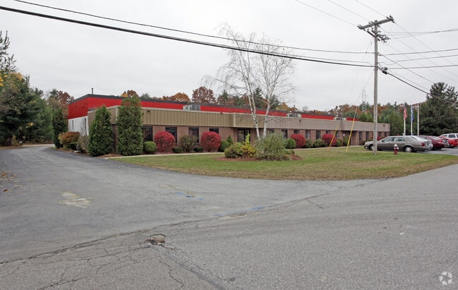
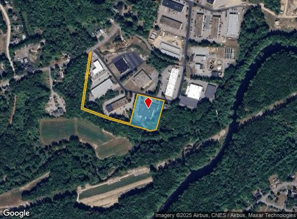
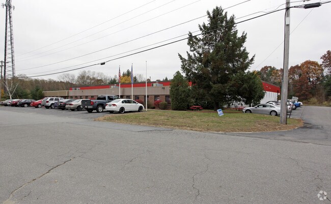
Property Record
21 Lomar Park, Pepperell, MA 01463
NEARBY LISTINGS FOR SALE OR LEASE
Property Detail
21 Lomar Park
Manufacturinglight
Middlesex
AE
Massachusetts
25017C0087F
3.21 AC
2025
Groton/Townsend
2025
Boston
327101
Boston-Cambridge-Newton, MA-NH
29,140 SF
PEPP-000016-000066
DEMOGRAPHICS near 21 Lomar Park
1 Mile
3 Mile
5 Mile
2024 Total Population
4,018
12,314
32,651
2029 Population
3,957
12,160
32,540
Pop Growth 2024-2029
(1.52%)
(1.25%)
(0.34%)
Average Age
42
43
43
2024 Total Households
1,563
4,617
12,029
HH Growth 2024-2029
(1.73%)
(1.36%)
(0.40%)
Median Household Inc
$108,109
$124,345
$130,130
Avg Household Size
2.60
2.60
2.70
2024 Avg HH Vehicles
2.00
2.00
2.00
Median Home Value
$394,428
$461,375
$470,424
Median Year Built
1974
1980
1982
Nearby Places
Map Layers
Map Styles
 Street
 Aerial
- Restaurants
- Banks
- Shops
- Fitness
- Groceries
PUBLIC TRANSPORTATION
AIRPORT
Manchester Boston Regional
DRIVE
WALK
Distance
Manchester Boston Regional
39 min
22.5 mi
Freight Ports
Port of Boston
DRIVE
WALK
Distance
Port of Boston
76 min
50.1 mi
Nearby Properties
Address
Land Use
TOTAL SIZE
Lot Size
Zoning
Address
Land Use
TOTAL SIZE
Lot Size
Zoning
161,690 SF
186 AC
RA
Address
Land Use
TOTAL SIZE
Lot Size
Zoning
127,577 SF
77.91 AC
TNR
Address
Land Use
TOTAL SIZE
Lot Size
Zoning
129,435 SF
29.90 AC
TNR
Address
Land Use
TOTAL SIZE
Lot Size
Zoning
42.06 AC
IND
Address
Land Use
TOTAL SIZE
Lot Size
Zoning
5.02 AC
SUR
Address
Land Use
TOTAL SIZE
Lot Size
Zoning
80,953 SF
2.60 AC
TNR
Address
Land Use
TOTAL SIZE
Lot Size
Zoning
8.32 AC
URR
Address
Land Use
TOTAL SIZE
Lot Size
Zoning
9.16 AC
IND
Address
Land Use
TOTAL SIZE
Lot Size
Zoning
2.88 AC
COM
Address
Land Use
TOTAL SIZE
Lot Size
Zoning
518.99 AC
RA
Address
Land Use
TOTAL SIZE
Lot Size
Zoning
13.19 AC
SUR
Address
Land Use
TOTAL SIZE
Lot Size
Zoning
180,434 SF
10.94 AC
IND
Address
Land Use
TOTAL SIZE
Lot Size
Zoning
6.46 AC
COM
Address
Land Use
TOTAL SIZE
Lot Size
Zoning
2.73 AC
COM
Address
Land Use
TOTAL SIZE
Lot Size
Zoning
2,307 SF
1.50 AC
URR
Address
Land Use
TOTAL SIZE
Lot Size
Zoning
175.67 AC
RUR
Address
Land Use
TOTAL SIZE
Lot Size
Zoning
41,336 SF
3.90 AC
IND
Address
Land Use
TOTAL SIZE
Lot Size
Zoning
23,720 SF
4.19 AC
IN
Address
Land Use
TOTAL SIZE
Lot Size
Zoning
12,254 SF
1.60 AC
TNR
Address
Land Use
TOTAL SIZE
Lot Size
Zoning
34,620 SF
6.02 AC
IN
Address
Land Use
TOTAL SIZE
Lot Size
Zoning
16,939 SF
1 AC
URR
Address
Land Use
TOTAL SIZE
Lot Size
Zoning
25,400 SF
9.30 AC
IND
Address
Land Use
TOTAL SIZE
Lot Size
Zoning
12,678 SF
1.31 AC
TNR
Address
Land Use
TOTAL SIZE
Lot Size
Zoning
12,640 SF
2 AC
TNR
Address
Land Use
TOTAL SIZE
Lot Size
Zoning
162.57 AC
Address
Land Use
TOTAL SIZE
Lot Size
Zoning
14,391 SF
1 AC
COM
Address
Land Use
TOTAL SIZE
Lot Size
Zoning
47.42 AC
R40
Address
Land Use
TOTAL SIZE
Lot Size
Zoning
11,098 SF
2.80 AC
COM
Address
Land Use
TOTAL SIZE
Lot Size
Zoning
14,952 SF
21 AC
R
Address
Land Use
TOTAL SIZE
Lot Size
Zoning
25,376 SF
2.55 AC
IN
The World's #1 Commercial Real Estate Marketplace
Connect with us
© 2026 CoStar Group
The information above has been obtained from sources believed reliable. While we do not doubt its accuracy we have not verified it and make no guarantee, warranty or representation about it. It is your responsibility to independently confirm its accuracy and completeness. Any projections, opinions, assumptions, or estimates used are for example only and do not represent the current or future performance of the property. The value of this transaction to you depends on tax and other factors which should be evaluated by your tax, financial, and legal advisors. You and your advisors should conduct a careful, independent investigation of the property to determine to your satisfaction the suitability of the property for your needs.