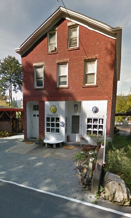
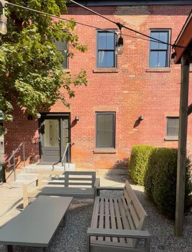
Property Record
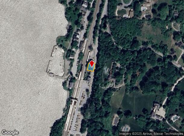
21 Lower Station Rd, Garrison, NY 10524

Current Lease Availabilities
NEARBY LISTINGS FOR SALE OR LEASE
Property Detail
21 Lower Station Rd
372689-060-017-0001-005-000-0000
LAND & RESIDENCE
Commercialnec
Putnam
X
New York
36079C0089E
5.000
2024
0.10 AC
2024
Carmel
010800
Westchester/So Connecticut
3,375 SF
Dutchess County-Putnam County, NY
DEMOGRAPHICS near 21 Lower Station Rd
1 Mile
3 Mile
5 Mile
2024 Total Population
1,244
16,829
29,240
2029 Population
1,279
17,256
29,634
Pop Growth 2024-2029
+ 2.81%
+ 2.54%
+ 1.35%
Average Age
31
34
38
2024 Total Households
265
4,576
9,134
HH Growth 2024-2029
+ 2.64%
+ 2.49%
+ 1.11%
Median Household Inc
$123,408
$112,411
$111,943
Avg Household Size
3.00
2.70
2.70
2024 Avg HH Vehicles
2.00
2.00
2.00
Median Home Value
$674,528
$442,968
$401,853
Median Year Built
1958
1957
1959
Nearby Places
- Restaurants
- Banks
- Shops
- Fitness
- Groceries
PUBLIC TRANSPORTATION
TRANSIT/SUBWAY
Garrison Station (Hudson Line - Metro-North Commuter Railroad Company (Metro-North))
DRIVE
WALK
Distance
Garrison Station (Hudson Line - Metro-North Commuter Railroad Company (Metro-North))
1 min
2 min
0.1 mi
COMMUTER RAIL
Garrison Station (Hudson Line - Metro-North Commuter Railroad Company (Metro-North))
DRIVE
WALK
Distance
Garrison Station (Hudson Line - Metro-North Commuter Railroad Company (Metro-North))
1 min
2 min
0.1 mi
Manitou Station (Hudson Line - Metro-North Commuter Railroad Company (Metro-North))
DRIVE
WALK
Distance
Manitou Station (Hudson Line - Metro-North Commuter Railroad Company (Metro-North))
9 min
4.3 mi
AIRPORT
New York Stewart International
DRIVE
WALK
Distance
New York Stewart International
41 min
22.5 mi
Westchester County
DRIVE
WALK
Distance
Westchester County
52 min
36.3 mi
Freight Ports
Maher Terminal
DRIVE
WALK
Distance
Maher Terminal
83 min
61.3 mi
Nearby Properties
Address
Land Use
TOTAL SIZE
Lot Size
Zoning
Address
Land Use
TOTAL SIZE
Lot Size
Zoning
363,657 SF
111.83 AC
B2
Address
Land Use
TOTAL SIZE
Lot Size
Zoning
19.90 AC
01
Address
Land Use
TOTAL SIZE
Lot Size
Zoning
119,474 SF
214.27 AC
R80
Address
Land Use
TOTAL SIZE
Lot Size
Zoning
95,159 SF
34.56 AC
B2
Address
Land Use
TOTAL SIZE
Lot Size
Zoning
132,468 SF
33.40 AC
Address
Land Use
TOTAL SIZE
Lot Size
Zoning
100,369 SF
11.96 AC
R10
Address
Land Use
TOTAL SIZE
Lot Size
Zoning
42,600 SF
18.90 AC
R80
Address
Land Use
TOTAL SIZE
Lot Size
Zoning
233,706 SF
11.65 AC
R80
Address
Land Use
TOTAL SIZE
Lot Size
Zoning
42,411 SF
5.17 AC
R10
Address
Land Use
TOTAL SIZE
Lot Size
Zoning
Address
Land Use
TOTAL SIZE
Lot Size
Zoning
25,540 SF
6.70 AC
R-4
Address
Land Use
TOTAL SIZE
Lot Size
Zoning
14,720 SF
2.50 AC
R-5
Address
Land Use
TOTAL SIZE
Lot Size
Zoning
44,052 SF
23.97 AC
R80
Address
Land Use
TOTAL SIZE
Lot Size
Zoning
12,747 SF
35.73 AC
R80
Address
Land Use
TOTAL SIZE
Lot Size
Zoning
13,650 SF
16.46 AC
R80
Address
Land Use
TOTAL SIZE
Lot Size
Zoning
4,512 SF
10.70 AC
R-1
Address
Land Use
TOTAL SIZE
Lot Size
Zoning
43,907 SF
1.20 AC
R-5
Address
Land Use
TOTAL SIZE
Lot Size
Zoning
35,775 SF
1.70 AC
R-5
Address
Land Use
TOTAL SIZE
Lot Size
Zoning
30,927 SF
1.31 AC
R-3
Address
Land Use
TOTAL SIZE
Lot Size
Zoning
21,120 SF
43.91 AC
R80
Address
Land Use
TOTAL SIZE
Lot Size
Zoning
Address
Land Use
TOTAL SIZE
Lot Size
Zoning
19,138 SF
8.49 AC
R40
Address
Land Use
TOTAL SIZE
Lot Size
Zoning
39,971 SF
10.39 AC
R10
Address
Land Use
TOTAL SIZE
Lot Size
Zoning
17,300 SF
1.43 AC
B-1
Address
Land Use
TOTAL SIZE
Lot Size
Zoning
29,176 SF
66.77 AC
R80
Address
Land Use
TOTAL SIZE
Lot Size
Zoning
29,272 SF
1.20 AC
Address
Land Use
TOTAL SIZE
Lot Size
Zoning
27,213 SF
1.20 AC
Address
Land Use
TOTAL SIZE
Lot Size
Zoning
21,729 SF
7.32 AC
B1
Address
Land Use
TOTAL SIZE
Lot Size
Zoning
11,800 SF
1.50 AC
R-2
The World's #1 Commercial Real Estate Marketplace
Connect with us
© 2025 CoStar Group
The information above has been obtained from sources believed reliable. While we do not doubt its accuracy we have not verified it and make no guarantee, warranty or representation about it. It is your responsibility to independently confirm its accuracy and completeness. Any projections, opinions, assumptions, or estimates used are for example only and do not represent the current or future performance of the property. The value of this transaction to you depends on tax and other factors which should be evaluated by your tax, financial, and legal advisors. You and your advisors should conduct a careful, independent investigation of the property to determine to your satisfaction the suitability of the property for your needs.