Property Record
21 Main St, Lunenburg, MA 01462

Save to a Folder
{{folder.Name}}
{{folder.ListingIds.length}} Properties
{{folder.ListingIds.length}} Property
Create a New Folder
Property Detail
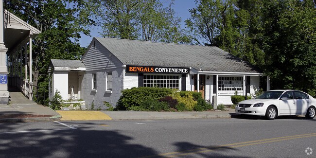
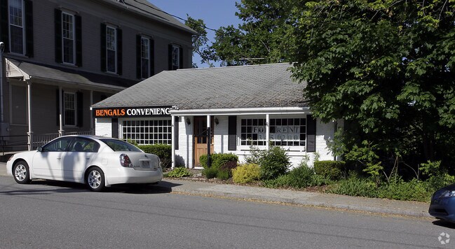
21 Main St
Officebuilding
Worcester
C
Massachusetts
B and X Area of moderate flood hazard, usually the area between the limits of the 100-year and 500-year floods.
0.14 AC
2025
Fitchburg/Leominster
2025
Boston
712101
Worcester, MA
1,260 SF
LUNE-000600-000006
NEARBY LISTINGS FOR SALE OR LEASE
DEMOGRAPHICS near 21 Main St
1 mile
3 mile
5 mile
2025 Total Population
1,909
19,012
74,207
2030 Population
1,977
19,596
76,187
Pop Growth 2025-2030
+ 3.56%
+ 3.07%
+ 2.67%
Average Age
44
42
40
2025 Total Households
746
7,368
28,828
HH Growth 2025-2030
+ 3.49%
+ 3.05%
+ 2.73%
Median Household Inc
$126,548
$102,859
$84,660
Avg Household Size
2.50
2.50
2.50
2025 Avg HH Vehicles
2.00
2.00
2.00
Median Home Value
$530,466
$454,701
$408,342
Median Year Built
1971
1970
1961
Nearby Places
Map Layers
Map Styles
 Street
 Aerial
Layers
 Traffic
 Biking
Places
Listings with unknown addresses are not visible on the map
- Restaurants
- Banks
- Shops
- Fitness
- Groceries
PUBLIC TRANSPORTATION
COMMUTER RAIL
North Leominster (Fitchburg/South Acton Line - Massachusetts Bay Transportation Authority Commuter Rail (Purple Line))
Drive
Walk
Distance
North Leominster (Fitchburg/South Acton Line - Massachusetts Bay Transportation Authority Commuter Rail (Purple Line))
10 min
4.3 mi
Fitchburg (Fitchburg/South Acton Line - Massachusetts Bay Transportation Authority Commuter Rail (Purple Line))
Drive
Walk
Distance
Fitchburg (Fitchburg/South Acton Line - Massachusetts Bay Transportation Authority Commuter Rail (Purple Line))
11 min
4.6 mi
AIRPORT
Worcester Regional
Drive
Walk
Distance
Worcester Regional
48 min
31.2 mi
Manchester Boston Regional
Drive
Walk
Distance
Manchester Boston Regional
61 min
34.3 mi
Freight Ports
Port of Boston
Drive
Walk
Distance
Port of Boston
75 min
47.5 mi
Nearby Properties
Address
Land Use
TOTAL SIZE
Lot Size
Zoning
Address
Land Use
TOTAL SIZE
Lot Size
Zoning
57,459 SF
37.03 AC
RA
Address
Land Use
TOTAL SIZE
Lot Size
Zoning
20,188 SF
18.86 AC
Address
Land Use
TOTAL SIZE
Lot Size
Zoning
35.43 AC
RA
Address
Land Use
TOTAL SIZE
Lot Size
Zoning
Address
Land Use
TOTAL SIZE
Lot Size
Zoning
9.95 AC
Address
Land Use
TOTAL SIZE
Lot Size
Zoning
52,300 SF
48.84 AC
C
Address
Land Use
TOTAL SIZE
Lot Size
Zoning
50,200 SF
16.34 AC
RA
Address
Land Use
TOTAL SIZE
Lot Size
Zoning
159,945 SF
14.63 AC
C
Address
Land Use
TOTAL SIZE
Lot Size
Zoning
6.50 AC
RB
Address
Land Use
TOTAL SIZE
Lot Size
Zoning
74,160 SF
Address
Land Use
TOTAL SIZE
Lot Size
Zoning
65,440 SF
5.23 AC
C
Address
Land Use
TOTAL SIZE
Lot Size
Zoning
27,248 SF
25 AC
RA
Address
Land Use
TOTAL SIZE
Lot Size
Zoning
45,620 SF
3.54 AC
Address
Land Use
TOTAL SIZE
Lot Size
Zoning
25,531 SF
4.69 AC
C
Address
Land Use
TOTAL SIZE
Lot Size
Zoning
448 SF
132 AC
RB
Address
Land Use
TOTAL SIZE
Lot Size
Zoning
147,276 SF
7 AC
Address
Land Use
TOTAL SIZE
Lot Size
Zoning
33,454 SF
15.78 AC
C
Address
Land Use
TOTAL SIZE
Lot Size
Zoning
2.36 AC
Address
Land Use
TOTAL SIZE
Lot Size
Zoning
63.80 AC
RA
Address
Land Use
TOTAL SIZE
Lot Size
Zoning
15,694 SF
1.77 AC
RA
Address
Land Use
TOTAL SIZE
Lot Size
Zoning
1,296 SF
6 AC
RA
Address
Land Use
TOTAL SIZE
Lot Size
Zoning
30,532 SF
2.14 AC
Address
Land Use
TOTAL SIZE
Lot Size
Zoning
9.42 AC
C
Address
Land Use
TOTAL SIZE
Lot Size
Zoning
4.65 AC
C
Address
Land Use
TOTAL SIZE
Lot Size
Zoning
26,522 SF
4.66 AC
I
Address
Land Use
TOTAL SIZE
Lot Size
Zoning
24,678 SF
4 AC
C
Address
Land Use
TOTAL SIZE
Lot Size
Zoning
12,434 SF
3.28 AC
Address
Land Use
TOTAL SIZE
Lot Size
Zoning
0.61 AC
Address
Land Use
TOTAL SIZE
Lot Size
Zoning
Address
Land Use
TOTAL SIZE
Lot Size
Zoning
57,608 SF
3.54 AC
C
The World's #1 Commercial Real Estate Marketplace
Connect with us
© 2026 CoStar Group
The information above has been obtained from sources believed reliable. While we do not doubt its accuracy we have not verified it and make no guarantee, warranty or representation about it. It is your responsibility to independently confirm its accuracy and completeness. Any projections, opinions, assumptions, or estimates used are for example only and do not represent the current or future performance of the property. The value of this transaction to you depends on tax and other factors which should be evaluated by your tax, financial, and legal advisors. You and your advisors should conduct a careful, independent investigation of the property to determine to your satisfaction the suitability of the property for your needs.