Property Record
21 N Main St, Munroe Falls, OH 44262


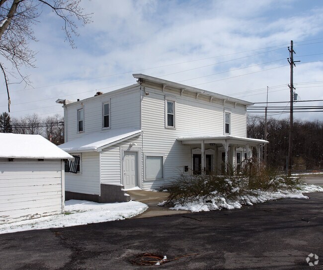
Property Detail
21 N Main St
Akron, OH
LOT 6 S OF RR & W OF N MAIN ST(DARROW RD)
58-02558
Summit
Officebuilding
Ohio
B and X Area of moderate flood hazard, usually the area between the limits of the 100-year and 500-year floods.
6
2023
0.29 AC
2025
Akron
530800
Cleveland
2,008 SF
NEARBY LISTINGS FOR SALE OR LEASE
DEMOGRAPHICS near 21 N Main St
1 mile
3 mile
5 mile
2025 Total Population
6,379
67,868
169,897
2030 Population
6,385
67,764
169,849
Pop Growth 2025-2030
+ 0.09%
(0.15%)
(0.03%)
Average Age
45
42
41
2025 Total Households
2,685
30,222
73,460
HH Growth 2025-2030
0.00%
(0.15%)
(0.03%)
Median Household Inc
$72,926
$72,081
$68,657
Avg Household Size
2.30
2.20
2.20
2025 Avg HH Vehicles
2.00
2.00
2.00
Median Home Value
$219,098
$198,963
$196,993
Median Year Built
1971
1965
1965
Nearby Places
Map Layers
Map Styles
 Street
 Aerial
Layers
 Traffic
 Biking
Places
Listings with unknown addresses are not visible on the map
- Restaurants
- Banks
- Shops
- Fitness
- Groceries
PUBLIC TRANSPORTATION
COMMUTER RAIL
Drive
Walk
Distance
14 min
7.2 mi
Drive
Walk
Distance
19 min
7.4 mi
AIRPORT
Akron-Canton Regional
Drive
Walk
Distance
Akron-Canton Regional
29 min
19.8 mi
Cleveland-Hopkins International
Drive
Walk
Distance
Cleveland-Hopkins International
54 min
38.1 mi
Nearby Properties
Address
Land Use
TOTAL SIZE
Lot Size
Zoning
Address
Land Use
TOTAL SIZE
Lot Size
Zoning
342,850 SF
86.98 AC
Address
Land Use
TOTAL SIZE
Lot Size
Zoning
77,663 SF
83.47 AC
Address
Land Use
TOTAL SIZE
Lot Size
Zoning
Address
Land Use
TOTAL SIZE
Lot Size
Zoning
57,908 SF
6.36 AC
Address
Land Use
TOTAL SIZE
Lot Size
Zoning
176,533 SF
62.50 AC
Address
Land Use
TOTAL SIZE
Lot Size
Zoning
314,622 SF
15.59 AC
Address
Land Use
TOTAL SIZE
Lot Size
Zoning
64,501 SF
175.97 AC
Address
Land Use
TOTAL SIZE
Lot Size
Zoning
297,758 SF
23.28 AC
Address
Land Use
TOTAL SIZE
Lot Size
Zoning
229,392 SF
12.31 AC
Address
Land Use
TOTAL SIZE
Lot Size
Zoning
52,646 SF
69.69 AC
Address
Land Use
TOTAL SIZE
Lot Size
Zoning
278,319 SF
34.50 AC
Address
Land Use
TOTAL SIZE
Lot Size
Zoning
169,260 SF
9.95 AC
Address
Land Use
TOTAL SIZE
Lot Size
Zoning
Address
Land Use
TOTAL SIZE
Lot Size
Zoning
131,788 SF
13.99 AC
Address
Land Use
TOTAL SIZE
Lot Size
Zoning
Address
Land Use
TOTAL SIZE
Lot Size
Zoning
Address
Land Use
TOTAL SIZE
Lot Size
Zoning
119,896 SF
3.19 AC
Address
Land Use
TOTAL SIZE
Lot Size
Zoning
538,138 SF
37.59 AC
Address
Land Use
TOTAL SIZE
Lot Size
Zoning
90,014 SF
5.84 AC
Address
Land Use
TOTAL SIZE
Lot Size
Zoning
90,820 SF
23.72 AC
Address
Land Use
TOTAL SIZE
Lot Size
Zoning
5.84 AC
Address
Land Use
TOTAL SIZE
Lot Size
Zoning
68,855 SF
32.57 AC
Address
Land Use
TOTAL SIZE
Lot Size
Zoning
140,288 SF
19.51 AC
Address
Land Use
TOTAL SIZE
Lot Size
Zoning
70,432 SF
2.28 AC
Address
Land Use
TOTAL SIZE
Lot Size
Zoning
107,704 SF
10.13 AC
Address
Land Use
TOTAL SIZE
Lot Size
Zoning
84,018 SF
2.07 AC
Address
Land Use
TOTAL SIZE
Lot Size
Zoning
0.34 AC
Address
Land Use
TOTAL SIZE
Lot Size
Zoning
105,404 SF
31.05 AC
Address
Land Use
TOTAL SIZE
Lot Size
Zoning
149,465 SF
13.60 AC
Address
Land Use
TOTAL SIZE
Lot Size
Zoning
96,691 SF
1.58 AC
The World's #1 Commercial Real Estate Marketplace
Connect with us
© 2026 CoStar Group
The information above has been obtained from sources believed reliable. While we do not doubt its accuracy we have not verified it and make no guarantee, warranty or representation about it. It is your responsibility to independently confirm its accuracy and completeness. Any projections, opinions, assumptions, or estimates used are for example only and do not represent the current or future performance of the property. The value of this transaction to you depends on tax and other factors which should be evaluated by your tax, financial, and legal advisors. You and your advisors should conduct a careful, independent investigation of the property to determine to your satisfaction the suitability of the property for your needs.