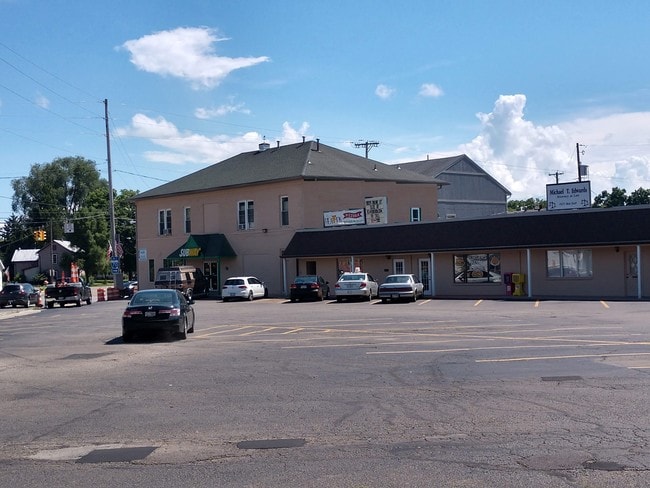
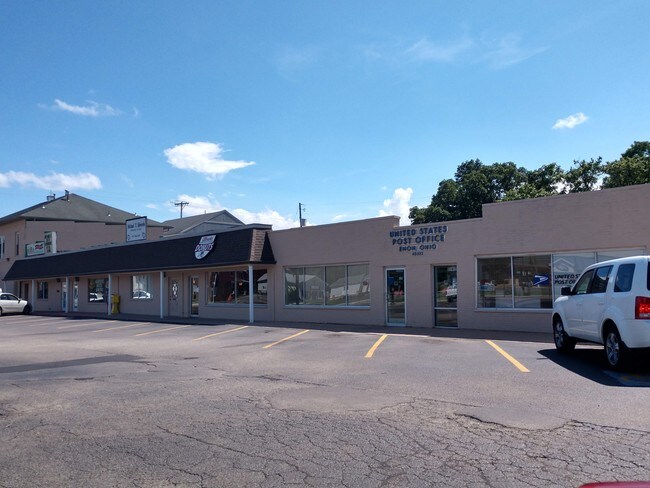
Property Record
21 N Xenia Dr, Enon, OH 45323
NEARBY LISTINGS FOR SALE OR LEASE
Property Detail
21 N Xenia Dr
Springfield, OH
Cory & Baker
21-00500-00140-2015
CORY & BAKER PTS EACH 52 TO 55 & 60
Regionalshoppingcenterormallwithanchorstore
Clark
X
Ohio
39023C0170E
17
2023
0.30 AC
2024
Northeast Dayton
003102
Cincinnati/Dayton
5,000 SF
DEMOGRAPHICS near 21 N Xenia Dr
1 Mile
3 Mile
5 Mile
2024 Total Population
3,225
10,299
25,038
2029 Population
3,178
10,207
24,887
Pop Growth 2024-2029
(1.46%)
(0.89%)
(0.60%)
Average Age
41
44
44
2024 Total Households
1,305
4,225
10,211
HH Growth 2024-2029
(1.53%)
(0.90%)
(0.57%)
Median Household Inc
$77,875
$81,901
$78,760
Avg Household Size
2.50
2.40
2.40
2024 Avg HH Vehicles
2.00
2.00
2.00
Median Home Value
$152,976
$184,342
$181,498
Median Year Built
1964
1969
1967
Nearby Places
Map Layers
Map Styles
 Street
 Aerial
- Restaurants
- Banks
- Shops
- Fitness
- Groceries
PUBLIC TRANSPORTATION
AIRPORT
James M Cox Dayton International
DRIVE
WALK
Distance
James M Cox Dayton International
27 min
20.2 mi
SALE & LEASE HISTORY
LISTING DATE
SALE/LEASE

Oct 18, 2021
For Lease
Oct 05, 2022
For Lease
Oct 05, 2022
For Sale
Nov 13, 2017
For Lease
Nov 07, 2017
For Sale
Feb 18, 2022
For Sale
Nearby Properties
Address
Land Use
TOTAL SIZE
Lot Size
Zoning
Address
Land Use
TOTAL SIZE
Lot Size
Zoning
34.06 AC
Address
Land Use
TOTAL SIZE
Lot Size
Zoning
6,495 SF
38.20 AC
Address
Land Use
TOTAL SIZE
Lot Size
Zoning
144,644 SF
38.20 AC
I-1
Address
Land Use
TOTAL SIZE
Lot Size
Zoning
61,121 SF
7.73 AC
R-2A
Address
Land Use
TOTAL SIZE
Lot Size
Zoning
55,805 SF
9.30 AC
B-3
Address
Land Use
TOTAL SIZE
Lot Size
Zoning
2.94 AC
Address
Land Use
TOTAL SIZE
Lot Size
Zoning
2,456 SF
559 AC
A-1
Address
Land Use
TOTAL SIZE
Lot Size
Zoning
84,432 SF
13.39 AC
I-1
Address
Land Use
TOTAL SIZE
Lot Size
Zoning
40,000 SF
10.41 AC
I-1
Address
Land Use
TOTAL SIZE
Lot Size
Zoning
11,121 SF
1.69 AC
Address
Land Use
TOTAL SIZE
Lot Size
Zoning
402.31 AC
A-1
Address
Land Use
TOTAL SIZE
Lot Size
Zoning
43.31 AC
Address
Land Use
TOTAL SIZE
Lot Size
Zoning
2,556 SF
338.34 AC
Address
Land Use
TOTAL SIZE
Lot Size
Zoning
42,738 SF
4.58 AC
B-2
Address
Land Use
TOTAL SIZE
Lot Size
Zoning
15,982 SF
3.93 AC
Address
Land Use
TOTAL SIZE
Lot Size
Zoning
249.99 AC
A-1
Address
Land Use
TOTAL SIZE
Lot Size
Zoning
7.16 AC
Address
Land Use
TOTAL SIZE
Lot Size
Zoning
102,224 SF
12.10 AC
Address
Land Use
TOTAL SIZE
Lot Size
Zoning
1,680 SF
183.63 AC
A-1
Address
Land Use
TOTAL SIZE
Lot Size
Zoning
3,070 SF
176.10 AC
A-1
Address
Land Use
TOTAL SIZE
Lot Size
Zoning
4,356 SF
201.93 AC
A1
Address
Land Use
TOTAL SIZE
Lot Size
Zoning
1,568 SF
196.15 AC
Address
Land Use
TOTAL SIZE
Lot Size
Zoning
159.50 AC
Address
Land Use
TOTAL SIZE
Lot Size
Zoning
202.42 AC
A-1
Address
Land Use
TOTAL SIZE
Lot Size
Zoning
7,262 SF
88.50 AC
A-1
Address
Land Use
TOTAL SIZE
Lot Size
Zoning
7,304 SF
142.87 AC
A-1
Address
Land Use
TOTAL SIZE
Lot Size
Zoning
4,868 SF
129.27 AC
A-1
Address
Land Use
TOTAL SIZE
Lot Size
Zoning
2,240 SF
148.35 AC
A-1
Address
Land Use
TOTAL SIZE
Lot Size
Zoning
32,788 SF
7.58 AC
Address
Land Use
TOTAL SIZE
Lot Size
Zoning
3,488 SF
133.33 AC
A-1
The World's #1 Commercial Real Estate Marketplace
Connect with us
© 2025 CoStar Group
The information above has been obtained from sources believed reliable. While we do not doubt its accuracy we have not verified it and make no guarantee, warranty or representation about it. It is your responsibility to independently confirm its accuracy and completeness. Any projections, opinions, assumptions, or estimates used are for example only and do not represent the current or future performance of the property. The value of this transaction to you depends on tax and other factors which should be evaluated by your tax, financial, and legal advisors. You and your advisors should conduct a careful, independent investigation of the property to determine to your satisfaction the suitability of the property for your needs.