Property Record
21 Sturbridge Rd, Brimfield, MA 01010
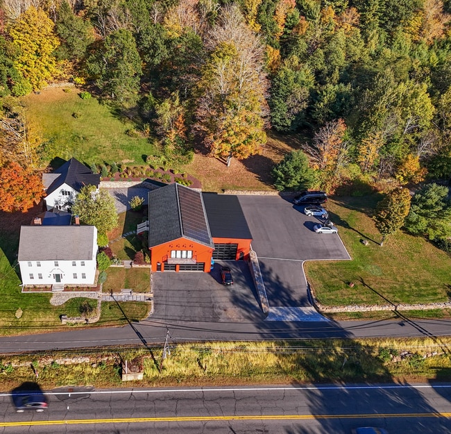
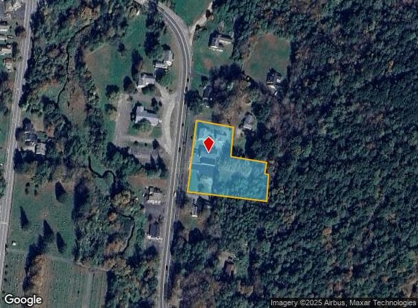

This Property Is For Sale
NEARBY LISTINGS FOR SALE OR LEASE
-
-
View all Brimfield listings for sale on LoopNet.com
Property Detail
21 Sturbridge Rd
Springfield, MA
Thaddeus J Jr & Kathleen D Cem
BRIM-000014AA000000-000013
Hampden
Sfr
Massachusetts
X
2 AC
25013C0477F
Hampden County
2,932 SF
Hartford
DEMOGRAPHICS near 21 Sturbridge Rd
1 Mile
3 Mile
5 Mile
2024 Total Population
903
2,953
12,186
2029 Population
910
2,987
12,524
Pop Growth 2024-2029
+ 0.78%
+ 1.15%
+ 2.77%
Average Age
46
45
44
2024 Total Households
364
1,191
4,902
HH Growth 2024-2029
+ 0.82%
+ 1.09%
+ 2.86%
Median Household Inc
$105,682
$101,974
$96,219
Avg Household Size
2.50
2.50
2.50
2024 Avg HH Vehicles
2.00
2.00
2.00
Median Home Value
$416,667
$396,257
$378,896
Median Year Built
1987
1986
1984
Nearby Places
Map Layers
Map Styles
 Street
 Aerial
- Restaurants
- Banks
- Shops
- Fitness
- Groceries
PUBLIC TRANSPORTATION
AIRPORT
Worcester Regional
DRIVE
WALK
Distance
Worcester Regional
46 min
28.2 mi
Bradley International
DRIVE
WALK
Distance
Bradley International
64 min
40.3 mi
Freight Ports
Port of Davisville, RI
DRIVE
WALK
Distance
Port of Davisville, RI
105 min
79.5 mi
Nearby Properties
Address
Land Use
TOTAL SIZE
Lot Size
Zoning
Address
Land Use
TOTAL SIZE
Lot Size
Zoning
1,846.93 AC
AR
Address
Land Use
TOTAL SIZE
Lot Size
Zoning
10.65 AC
B
Address
Land Use
TOTAL SIZE
Lot Size
Zoning
189.22 AC
B
Address
Land Use
TOTAL SIZE
Lot Size
Zoning
5.60 AC
AR
Address
Land Use
TOTAL SIZE
Lot Size
Zoning
65.96 AC
AR
Address
Land Use
TOTAL SIZE
Lot Size
Zoning
5.90 AC
1B
Address
Land Use
TOTAL SIZE
Lot Size
Zoning
9,812 SF
2 AC
B
Address
Land Use
TOTAL SIZE
Lot Size
Zoning
29,400 SF
4.63 AC
AR
Address
Land Use
TOTAL SIZE
Lot Size
Zoning
67.50 AC
AR
Address
Land Use
TOTAL SIZE
Lot Size
Zoning
2,944 SF
15 AC
AR
Address
Land Use
TOTAL SIZE
Lot Size
Zoning
4,732 SF
15 AC
B
Address
Land Use
TOTAL SIZE
Lot Size
Zoning
465.80 AC
AR
Address
Land Use
TOTAL SIZE
Lot Size
Zoning
4,920 SF
0.47 AC
B
Address
Land Use
TOTAL SIZE
Lot Size
Zoning
53.47 AC
AR
Address
Land Use
TOTAL SIZE
Lot Size
Zoning
5,856 SF
0.90 AC
B
Address
Land Use
TOTAL SIZE
Lot Size
Zoning
33.60 AC
AR
Address
Land Use
TOTAL SIZE
Lot Size
Zoning
10.16 AC
AR
Address
Land Use
TOTAL SIZE
Lot Size
Zoning
8,114 SF
2.04 AC
B
Address
Land Use
TOTAL SIZE
Lot Size
Zoning
Address
Land Use
TOTAL SIZE
Lot Size
Zoning
1,392 SF
13.48 AC
B
Address
Land Use
TOTAL SIZE
Lot Size
Zoning
4,000 SF
12 AC
B
Address
Land Use
TOTAL SIZE
Lot Size
Zoning
20,218 SF
82 AC
B
Address
Land Use
TOTAL SIZE
Lot Size
Zoning
5,351 SF
2.01 AC
B
Address
Land Use
TOTAL SIZE
Lot Size
Zoning
2,040 SF
7.20 AC
Address
Land Use
TOTAL SIZE
Lot Size
Zoning
4.29 AC
AR
Address
Land Use
TOTAL SIZE
Lot Size
Zoning
3,273 SF
0.19 AC
B
Address
Land Use
TOTAL SIZE
Lot Size
Zoning
9.27 AC
B
Address
Land Use
TOTAL SIZE
Lot Size
Zoning
1.96 AC
AR
Address
Land Use
TOTAL SIZE
Lot Size
Zoning
7,634 SF
0.15 AC
B
Address
Land Use
TOTAL SIZE
Lot Size
Zoning
312 AC
The World's #1 Commercial Real Estate Marketplace
Connect with us
© 2026 CoStar Group
The information above has been obtained from sources believed reliable. While we do not doubt its accuracy we have not verified it and make no guarantee, warranty or representation about it. It is your responsibility to independently confirm its accuracy and completeness. Any projections, opinions, assumptions, or estimates used are for example only and do not represent the current or future performance of the property. The value of this transaction to you depends on tax and other factors which should be evaluated by your tax, financial, and legal advisors. You and your advisors should conduct a careful, independent investigation of the property to determine to your satisfaction the suitability of the property for your needs.