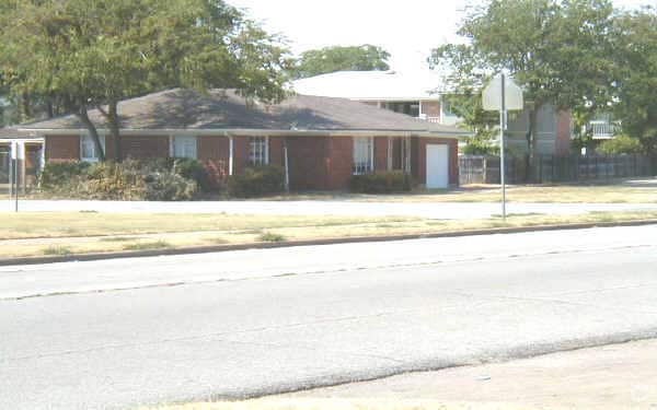
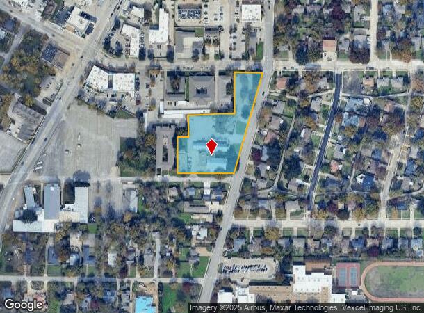
Property Record
210 Abrams Rd, Richardson, TX 75081


NEARBY LISTINGS FOR SALE OR LEASE
Property Detail
210 Abrams Rd
Dallas-Fort Worth-Arlington, TX
Community Bible Chapel
42048800010010000
COMMUNITY BIBLE CHAPEL BLK 1 LOT 1 ACS 2.3149 VOL2000150/3763 DD07312000 CO-DC 0488000100100 34204880001
Religious
Dallas
X
Texas
48085C0505K
1
0
2.32 AC
2025
Richardson
019102
Dallas/Ft Worth
100 SF
DEMOGRAPHICS near 210 Abrams Rd
1 mile
3 mile
5 mile
2024 Total Population
14,027
154,029
388,923
2029 Population
13,833
153,056
399,227
Pop Growth 2024-2029
(1.38%)
(0.63%)
+ 2.65%
Average Age
38
36
37
2024 Total Households
5,672
57,783
157,126
HH Growth 2024-2029
(1.64%)
(0.71%)
+ 3.21%
Median Household Inc
$78,621
$59,989
$65,008
Avg Household Size
2.40
2.50
2.40
2024 Avg HH Vehicles
2.00
2.00
2.00
Median Home Value
$297,072
$304,133
$346,482
Median Year Built
1977
1976
1980
Nearby Places
Map Layers
Map Styles
 Street
 Aerial
Transit
 Traffic
 Biking
Places
Listings with unknown addresses are not visible on the map
- Restaurants
- Banks
- Shops
- Fitness
- Groceries
PUBLIC TRANSPORTATION
TRANSIT/SUBWAY
Spring Valley (Orange Line - Dallas Area Rapid Transit (DART), Red Line - Dallas Area Rapid Transit (DART))
Drive
Walk
Distance
Spring Valley (Orange Line - Dallas Area Rapid Transit (DART), Red Line - Dallas Area Rapid Transit (DART))
3 min
19 min
1.0 mi
AIRPORT
Dallas Love Field
Drive
Walk
Distance
Dallas Love Field
23 min
15.5 mi
Dallas-Fort Worth International
Drive
Walk
Distance
Dallas-Fort Worth International
31 min
24.4 mi
Freight Ports
Port of Shreveport
Drive
Walk
Distance
Port of Shreveport
217 min
199.3 mi
Nearby Properties
Address
Land Use
TOTAL SIZE
Lot Size
Zoning
Address
Land Use
TOTAL SIZE
Lot Size
Zoning
7,706,477 SF
245.55 AC
Z116
Address
Land Use
TOTAL SIZE
Lot Size
Zoning
641,243 SF
20.67 AC
Z109
Address
Land Use
TOTAL SIZE
Lot Size
Zoning
686,032 SF
9 AC
R2000
Address
Land Use
TOTAL SIZE
Lot Size
Zoning
706,061 SF
36.76 AC
Z109
Address
Land Use
TOTAL SIZE
Lot Size
Zoning
428,956 SF
18.76 AC
Z291
Address
Land Use
TOTAL SIZE
Lot Size
Zoning
795,714 SF
5.36 AC
Z109
Address
Land Use
TOTAL SIZE
Lot Size
Zoning
249,692 SF
244.62 AC
Z239
Address
Land Use
TOTAL SIZE
Lot Size
Zoning
402,815 SF
5.64 AC
Z236
Address
Land Use
TOTAL SIZE
Lot Size
Zoning
537,928 SF
11.13 AC
Z109
Address
Land Use
TOTAL SIZE
Lot Size
Zoning
426,467 SF
24.12 AC
Z142
Address
Land Use
TOTAL SIZE
Lot Size
Zoning
681,916 SF
4.80 AC
Z31
Address
Land Use
TOTAL SIZE
Lot Size
Zoning
1,464,834 SF
18.37 AC
Z109
Address
Land Use
TOTAL SIZE
Lot Size
Zoning
542,845 SF
3.90 AC
MF-R
Address
Land Use
TOTAL SIZE
Lot Size
Zoning
316,085 SF
13.73 AC
Z107
Address
Land Use
TOTAL SIZE
Lot Size
Zoning
596,546 SF
3.61 AC
Z31
Address
Land Use
TOTAL SIZE
Lot Size
Zoning
347,933 SF
12.61 AC
Z164
Address
Land Use
TOTAL SIZE
Lot Size
Zoning
1,099,201 SF
107.82 AC
Z116
Address
Land Use
TOTAL SIZE
Lot Size
Zoning
371,611 SF
4.48 AC
Z31
Address
Land Use
TOTAL SIZE
Lot Size
Zoning
470,129 SF
4.43 AC
Z112
Address
Land Use
TOTAL SIZE
Lot Size
Zoning
201,226 SF
14.55 AC
Z143
Address
Land Use
TOTAL SIZE
Lot Size
Zoning
187.94 AC
Z31
Address
Land Use
TOTAL SIZE
Lot Size
Zoning
291,579 SF
13.79 AC
Z151
Address
Land Use
TOTAL SIZE
Lot Size
Zoning
635,227 SF
3.57 AC
Z151
Address
Land Use
TOTAL SIZE
Lot Size
Zoning
572,364 SF
8.41 AC
Z112
Address
Land Use
TOTAL SIZE
Lot Size
Zoning
699,105 SF
5.12 AC
Z137
Address
Land Use
TOTAL SIZE
Lot Size
Zoning
334,910 SF
14.26 AC
Z151
Address
Land Use
TOTAL SIZE
Lot Size
Zoning
431,982 SF
19.32 AC
Z164
Address
Land Use
TOTAL SIZE
Lot Size
Zoning
277,296 SF
13.54 AC
Z207
Address
Land Use
TOTAL SIZE
Lot Size
Zoning
292,347 SF
3.82 AC
Z236
Address
Land Use
TOTAL SIZE
Lot Size
Zoning
211,913 SF
6.76 AC
Z151
The World's #1 Commercial Real Estate Marketplace
Connect with us
© 2026 CoStar Group
The information above has been obtained from sources believed reliable. While we do not doubt its accuracy we have not verified it and make no guarantee, warranty or representation about it. It is your responsibility to independently confirm its accuracy and completeness. Any projections, opinions, assumptions, or estimates used are for example only and do not represent the current or future performance of the property. The value of this transaction to you depends on tax and other factors which should be evaluated by your tax, financial, and legal advisors. You and your advisors should conduct a careful, independent investigation of the property to determine to your satisfaction the suitability of the property for your needs.