Property Record
210 Bell Ranch Rd, Spring Branch, TX 78070

NEARBY LISTINGS FOR SALE OR LEASE
-
-
View all Spring Branch listings for sale on LoopNet.com
Property Detail
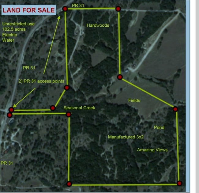
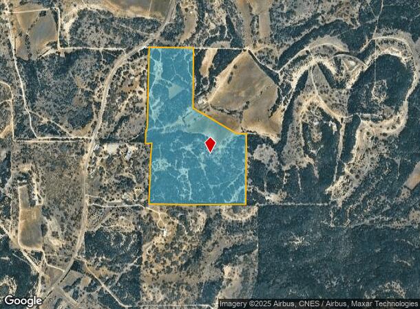
210 Bell Ranch Rd
74-0058-0001-03
A- 58 Sur-603 M Bechthold
Agriculturalland
A- 58 SUR-603 M BECHTHOLD, ACRES 99.807, SN1 CW2004465TX A; SN2 CW2004465TX B
X
Comal
48259C0450F
Texas
2024
99.81 AC
2025
Comal County
310702
San Antonio
2,106 SF
San Antonio-New Braunfels, TX
DEMOGRAPHICS near 210 Bell Ranch Rd
1 Mile
3 Mile
5 Mile
2024 Total Population
27
1,891
9,909
2029 Population
36
2,553
13,277
Pop Growth 2024-2029
+ 33.33%
+ 35.01%
+ 33.99%
Average Age
40
44
44
2024 Total Households
9
652
3,466
HH Growth 2024-2029
+ 33.33%
+ 35.28%
+ 33.99%
Median Household Inc
$112,500
$131,176
$126,908
Avg Household Size
2.80
2.80
2.80
2024 Avg HH Vehicles
2.00
3.00
3.00
Median Home Value
$499,999
$546,185
$557,593
Median Year Built
2003
2000
2002
Nearby Places
Map Layers
Map Styles
 Street
 Aerial
- Restaurants
- Banks
- Shops
- Fitness
- Groceries
PUBLIC TRANSPORTATION
AIRPORT
San Antonio International
DRIVE
WALK
Distance
San Antonio International
40 min
29.7 mi
Freight Ports
Calhoun Port
DRIVE
WALK
Distance
Calhoun Port
217 min
175.7 mi
SALE & LEASE HISTORY
LISTING DATE
SALE/LEASE

Jun 14, 2018
For Sale
Jan 21, 2024
For Sale
Nearby Properties
Address
Land Use
TOTAL SIZE
Lot Size
Zoning
Address
Land Use
TOTAL SIZE
Lot Size
Zoning
5,487 SF
515.01 AC
Address
Land Use
TOTAL SIZE
Lot Size
Zoning
304.30 AC
Address
Land Use
TOTAL SIZE
Lot Size
Zoning
37,551 SF
42.01 AC
Address
Land Use
TOTAL SIZE
Lot Size
Zoning
256.40 AC
Address
Land Use
TOTAL SIZE
Lot Size
Zoning
266.79 AC
Address
Land Use
TOTAL SIZE
Lot Size
Zoning
3,709 SF
37.93 AC
Address
Land Use
TOTAL SIZE
Lot Size
Zoning
13,646 SF
11.32 AC
Address
Land Use
TOTAL SIZE
Lot Size
Zoning
194.26 AC
Address
Land Use
TOTAL SIZE
Lot Size
Zoning
174.90 AC
Address
Land Use
TOTAL SIZE
Lot Size
Zoning
16,885 SF
16.01 AC
Address
Land Use
TOTAL SIZE
Lot Size
Zoning
12,075 SF
17.04 AC
Address
Land Use
TOTAL SIZE
Lot Size
Zoning
Address
Land Use
TOTAL SIZE
Lot Size
Zoning
Address
Land Use
TOTAL SIZE
Lot Size
Zoning
Address
Land Use
TOTAL SIZE
Lot Size
Zoning
126.43 AC
Address
Land Use
TOTAL SIZE
Lot Size
Zoning
Address
Land Use
TOTAL SIZE
Lot Size
Zoning
36.70 AC
Address
Land Use
TOTAL SIZE
Lot Size
Zoning
34.50 AC
Address
Land Use
TOTAL SIZE
Lot Size
Zoning
113.02 AC
Address
Land Use
TOTAL SIZE
Lot Size
Zoning
106.60 AC
Address
Land Use
TOTAL SIZE
Lot Size
Zoning
30,285 SF
3.23 AC
Address
Land Use
TOTAL SIZE
Lot Size
Zoning
9,629 SF
38.46 AC
Address
Land Use
TOTAL SIZE
Lot Size
Zoning
7,583 SF
21.80 AC
Address
Land Use
TOTAL SIZE
Lot Size
Zoning
Address
Land Use
TOTAL SIZE
Lot Size
Zoning
6,848 SF
52.14 AC
Address
Land Use
TOTAL SIZE
Lot Size
Zoning
Address
Land Use
TOTAL SIZE
Lot Size
Zoning
5,044 SF
50.91 AC
Address
Land Use
TOTAL SIZE
Lot Size
Zoning
82.20 AC
Address
Land Use
TOTAL SIZE
Lot Size
Zoning
Address
Land Use
TOTAL SIZE
Lot Size
Zoning
3,222 SF
88.47 AC
The World's #1 Commercial Real Estate Marketplace
Connect with us
© 2026 CoStar Group
The information above has been obtained from sources believed reliable. While we do not doubt its accuracy we have not verified it and make no guarantee, warranty or representation about it. It is your responsibility to independently confirm its accuracy and completeness. Any projections, opinions, assumptions, or estimates used are for example only and do not represent the current or future performance of the property. The value of this transaction to you depends on tax and other factors which should be evaluated by your tax, financial, and legal advisors. You and your advisors should conduct a careful, independent investigation of the property to determine to your satisfaction the suitability of the property for your needs.