Property Record
210 Chestnut St, Sterling, CO 80751
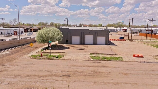


Property Detail
210 Chestnut St
Sterling, CO
SWLY 1/2 LOT 3 & LOT 4 EXC SWLY 35' BLK 14 K&S ADDN STERLING
3177000
Logan
Autorepair
Colorado
C and X Area of minimal flood hazard, usually depicted on FIRMs as above the 500-year flood level.
3-4
2025
0.30 AC
2025
Colorado East Area
966200
Other Market Areas
3,770 SF
NEARBY LISTINGS FOR SALE OR LEASE
DEMOGRAPHICS near 210 Chestnut St
1 mile
3 mile
5 mile
2025 Total Population
6,239
13,763
14,609
2030 Population
6,193
13,627
14,462
Pop Growth 2025-2030
(0.74%)
(0.99%)
(1.01%)
Average Age
39
41
41
2025 Total Households
2,705
5,663
6,004
HH Growth 2025-2030
(1.15%)
(1.40%)
(1.42%)
Median Household Inc
$45,633
$53,284
$55,172
Avg Household Size
2.10
2.20
2.20
2025 Avg HH Vehicles
2.00
2.00
2.00
Median Home Value
$207,389
$238,312
$243,319
Median Year Built
1952
1962
1962
Nearby Places
Map Layers
Map Styles
 Street
 Aerial
Transit
 Traffic
 Biking
Places
Listings with unknown addresses are not visible on the map
- Restaurants
- Banks
- Shops
- Fitness
- Groceries
SALE & LEASE HISTORY
LISTING DATE
SALE/LEASE

Jun 10, 2025
For Lease
Aug 19, 2023
For Lease
Nearby Properties
Address
Land Use
TOTAL SIZE
Lot Size
Zoning
Address
Land Use
TOTAL SIZE
Lot Size
Zoning
262,955 SF
26 AC
Address
Land Use
TOTAL SIZE
Lot Size
Zoning
160,000 SF
84 AC
Address
Land Use
TOTAL SIZE
Lot Size
Zoning
50,355 SF
4.22 AC
Address
Land Use
TOTAL SIZE
Lot Size
Zoning
93,227 SF
29.25 AC
Address
Land Use
TOTAL SIZE
Lot Size
Zoning
22,554 SF
2.76 AC
Address
Land Use
TOTAL SIZE
Lot Size
Zoning
57,641 SF
11.40 AC
Address
Land Use
TOTAL SIZE
Lot Size
Zoning
50,840 SF
39 AC
Address
Land Use
TOTAL SIZE
Lot Size
Zoning
40,212 SF
1.19 AC
Address
Land Use
TOTAL SIZE
Lot Size
Zoning
135,095 SF
35.79 AC
Address
Land Use
TOTAL SIZE
Lot Size
Zoning
45,162 SF
8.62 AC
Address
Land Use
TOTAL SIZE
Lot Size
Zoning
18,379 SF
2.50 AC
Address
Land Use
TOTAL SIZE
Lot Size
Zoning
50,800 SF
92.78 AC
Address
Land Use
TOTAL SIZE
Lot Size
Zoning
20,672 SF
4.17 AC
Address
Land Use
TOTAL SIZE
Lot Size
Zoning
36,586 SF
10 AC
Address
Land Use
TOTAL SIZE
Lot Size
Zoning
130,128 SF
53.03 AC
Address
Land Use
TOTAL SIZE
Lot Size
Zoning
26,424 SF
26.99 AC
Address
Land Use
TOTAL SIZE
Lot Size
Zoning
12,350 SF
0.96 AC
Address
Land Use
TOTAL SIZE
Lot Size
Zoning
18,110 SF
0.14 AC
Address
Land Use
TOTAL SIZE
Lot Size
Zoning
15,212 SF
5.56 AC
Address
Land Use
TOTAL SIZE
Lot Size
Zoning
19,880 SF
3 AC
Address
Land Use
TOTAL SIZE
Lot Size
Zoning
11,001 SF
3.67 AC
Address
Land Use
TOTAL SIZE
Lot Size
Zoning
34,634 SF
10 AC
Address
Land Use
TOTAL SIZE
Lot Size
Zoning
12,818 SF
4 AC
Address
Land Use
TOTAL SIZE
Lot Size
Zoning
179,474 SF
22.61 AC
Address
Land Use
TOTAL SIZE
Lot Size
Zoning
10,500 SF
14.63 AC
Address
Land Use
TOTAL SIZE
Lot Size
Zoning
19,124 SF
2.16 AC
Address
Land Use
TOTAL SIZE
Lot Size
Zoning
19,115 SF
1.65 AC
Address
Land Use
TOTAL SIZE
Lot Size
Zoning
14,324 SF
5 AC
Address
Land Use
TOTAL SIZE
Lot Size
Zoning
38,562 SF
2.03 AC
Address
Land Use
TOTAL SIZE
Lot Size
Zoning
4,608 SF
1.09 AC
The World's #1 Commercial Real Estate Marketplace
Connect with us
© 2026 CoStar Group
The information above has been obtained from sources believed reliable. While we do not doubt its accuracy we have not verified it and make no guarantee, warranty or representation about it. It is your responsibility to independently confirm its accuracy and completeness. Any projections, opinions, assumptions, or estimates used are for example only and do not represent the current or future performance of the property. The value of this transaction to you depends on tax and other factors which should be evaluated by your tax, financial, and legal advisors. You and your advisors should conduct a careful, independent investigation of the property to determine to your satisfaction the suitability of the property for your needs.