Property Record
210 Derrick Dr, Humble, TX 77338
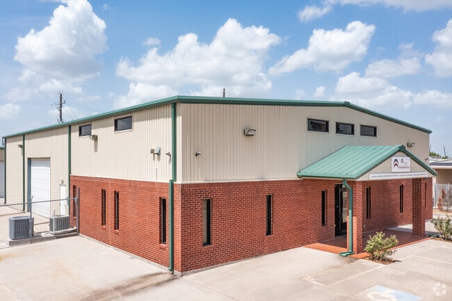

Property Detail
210 Derrick Dr
1305250010001
RES A BLK 1 HALBROOK ESTATES
Warehouse
HARRIS
B and X Area of moderate flood hazard, usually the area between the limits of the 100-year and 500-year floods.
Texas
2024
0.50 AC
2025
Northeast Hwy 90
250602
Houston
6,480 SF
Houston-Pasadena-The Woodlands, TX
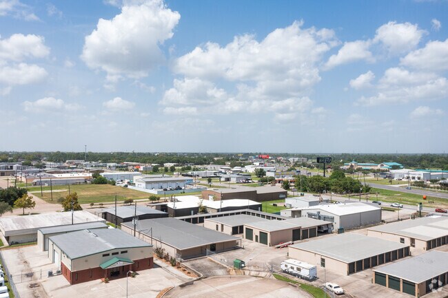
NEARBY LISTINGS FOR SALE OR LEASE
DEMOGRAPHICS near 210 Derrick Dr
1 mile
3 mile
5 mile
2025 Total Population
5,106
45,270
195,094
2030 Population
5,401
48,165
210,275
Pop Growth 2025-2030
+ 5.78%
+ 6.39%
+ 7.78%
Average Age
37
36
36
2025 Total Households
1,922
15,443
66,621
HH Growth 2025-2030
+ 5.83%
+ 6.57%
+ 8.26%
Median Household Inc
$41,100
$76,141
$89,632
Avg Household Size
2.60
2.90
2.90
2025 Avg HH Vehicles
1.00
2.00
2.00
Median Home Value
$234,375
$250,436
$285,249
Median Year Built
1976
1995
2002
Nearby Places
Map Layers
Map Styles
 Street
 Aerial
Layers
 Traffic
 Biking
Places
Listings with unknown addresses are not visible on the map
- Restaurants
- Banks
- Shops
- Fitness
- Groceries
PUBLIC TRANSPORTATION
AIRPORT
George Bush Intcntl/Houston
Drive
Walk
Distance
George Bush Intcntl/Houston
17 min
10.1 mi
William P Hobby
Drive
Walk
Distance
William P Hobby
49 min
31.7 mi
Freight Ports
Port of Houston
Drive
Walk
Distance
Port of Houston
38 min
25.4 mi
SALE & LEASE HISTORY
LISTING DATE
SALE/LEASE

May 04, 2021
For Sale
Jun 01, 2021
For Lease
Jan 04, 2019
For Sale
Nearby Properties
Address
Land Use
TOTAL SIZE
Lot Size
Zoning
Address
Land Use
TOTAL SIZE
Lot Size
Zoning
687,195 SF
33.75 AC
Address
Land Use
TOTAL SIZE
Lot Size
Zoning
685,400 SF
38.82 AC
Address
Land Use
TOTAL SIZE
Lot Size
Zoning
514,500 SF
40.85 AC
Address
Land Use
TOTAL SIZE
Lot Size
Zoning
429,750 SF
24.74 AC
Address
Land Use
TOTAL SIZE
Lot Size
Zoning
432,617 SF
19.41 AC
Address
Land Use
TOTAL SIZE
Lot Size
Zoning
326,166 SF
11.84 AC
Address
Land Use
TOTAL SIZE
Lot Size
Zoning
320,200 SF
19.56 AC
Address
Land Use
TOTAL SIZE
Lot Size
Zoning
212,020 SF
Address
Land Use
TOTAL SIZE
Lot Size
Zoning
449,858 SF
22.20 AC
Address
Land Use
TOTAL SIZE
Lot Size
Zoning
235,236 SF
15.14 AC
Address
Land Use
TOTAL SIZE
Lot Size
Zoning
216,978 SF
10.99 AC
Address
Land Use
TOTAL SIZE
Lot Size
Zoning
205,040 SF
10.51 AC
Address
Land Use
TOTAL SIZE
Lot Size
Zoning
268,939 SF
11.24 AC
Address
Land Use
TOTAL SIZE
Lot Size
Zoning
304,671 SF
14.77 AC
Address
Land Use
TOTAL SIZE
Lot Size
Zoning
196,468 SF
9.51 AC
Address
Land Use
TOTAL SIZE
Lot Size
Zoning
207,432 SF
15.12 AC
Address
Land Use
TOTAL SIZE
Lot Size
Zoning
165,737 SF
14 AC
Address
Land Use
TOTAL SIZE
Lot Size
Zoning
102,374 SF
13.48 AC
Address
Land Use
TOTAL SIZE
Lot Size
Zoning
156,756 SF
17.05 AC
Address
Land Use
TOTAL SIZE
Lot Size
Zoning
64,980 SF
4.19 AC
Address
Land Use
TOTAL SIZE
Lot Size
Zoning
56,344 SF
3.25 AC
Address
Land Use
TOTAL SIZE
Lot Size
Zoning
206,600 SF
23.09 AC
Address
Land Use
TOTAL SIZE
Lot Size
Zoning
168,400 SF
11.57 AC
Address
Land Use
TOTAL SIZE
Lot Size
Zoning
198,376 SF
12.40 AC
Address
Land Use
TOTAL SIZE
Lot Size
Zoning
98,124 SF
7.58 AC
Address
Land Use
TOTAL SIZE
Lot Size
Zoning
156,935 SF
24.24 AC
Address
Land Use
TOTAL SIZE
Lot Size
Zoning
63,507 SF
2.83 AC
Address
Land Use
TOTAL SIZE
Lot Size
Zoning
4,168 SF
20.04 AC
Address
Land Use
TOTAL SIZE
Lot Size
Zoning
213,292 SF
9.81 AC
Address
Land Use
TOTAL SIZE
Lot Size
Zoning
132,930 SF
11.23 AC
The World's #1 Commercial Real Estate Marketplace
Connect with us
© 2026 CoStar Group
The information above has been obtained from sources believed reliable. While we do not doubt its accuracy we have not verified it and make no guarantee, warranty or representation about it. It is your responsibility to independently confirm its accuracy and completeness. Any projections, opinions, assumptions, or estimates used are for example only and do not represent the current or future performance of the property. The value of this transaction to you depends on tax and other factors which should be evaluated by your tax, financial, and legal advisors. You and your advisors should conduct a careful, independent investigation of the property to determine to your satisfaction the suitability of the property for your needs.