Property Record
200 E Arrowhead Dr, Charlotte, NC 28213
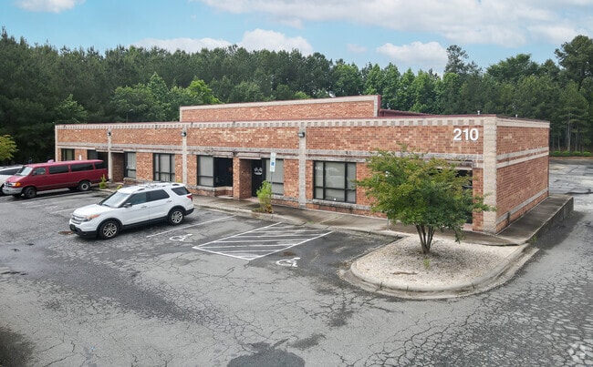


Property Detail
200 E Arrowhead Dr
049-041-11
P3A B1 M32-695
Industrialgeneral
Mecklenburg
I2
North Carolina
B and X Area of moderate flood hazard, usually the area between the limits of the 100-year and 500-year floods.
11
0
3.92 AC
2025
Mecklenburg Line
001505
Charlotte
25,690 SF
Charlotte-Concord-Gastonia, NC-SC
NEARBY LISTINGS FOR SALE OR LEASE
DEMOGRAPHICS near 200 E Arrowhead Dr
1 mile
3 mile
5 mile
2024 Total Population
12,317
93,669
269,313
2029 Population
13,436
102,372
293,798
Pop Growth 2024-2029
+ 9.09%
+ 9.29%
+ 9.09%
Average Age
34
36
36
2024 Total Households
4,290
36,393
110,692
HH Growth 2024-2029
+ 9.16%
+ 9.42%
+ 9.29%
Median Household Inc
$47,087
$58,369
$64,868
Avg Household Size
2.70
2.50
2.30
2024 Avg HH Vehicles
2.00
2.00
2.00
Median Home Value
$223,159
$330,416
$351,938
Median Year Built
1982
1989
1993
Nearby Places
Map Layers
Map Styles
 Street
 Aerial
Transit
 Traffic
 Biking
Places
Listings with unknown addresses are not visible on the map
- Restaurants
- Banks
- Shops
- Fitness
- Groceries
PUBLIC TRANSPORTATION
TRANSIT/SUBWAY
Tom Hunter Station (Light Rail - Lynx Blue Line - CATS)
Drive
Walk
Distance
Tom Hunter Station (Light Rail - Lynx Blue Line - CATS)
3 min
13 min
0.7 mi
Old Concord Road Station (Light Rail - Lynx Blue Line - CATS)
Drive
Walk
Distance
Old Concord Road Station (Light Rail - Lynx Blue Line - CATS)
4 min
20 min
1.1 mi
COMMUTER RAIL
Charlotte Amtrak Station (Carolinian - Amtrak, Crescent - Amtrak, Piedmont - Amtrak)
Drive
Walk
Distance
Charlotte Amtrak Station (Carolinian - Amtrak, Crescent - Amtrak, Piedmont - Amtrak)
9 min
4.6 mi
AIRPORT
Concord-Padgett Regional
Drive
Walk
Distance
Concord-Padgett Regional
19 min
10.6 mi
Charlotte/Douglas International
Drive
Walk
Distance
Charlotte/Douglas International
26 min
13.4 mi
Freight Ports
North Charleston Terminal
Drive
Walk
Distance
North Charleston Terminal
239 min
205.2 mi
SALE & LEASE HISTORY
LISTING DATE
SALE/LEASE

Sep 25, 2016
For Lease
May 23, 2017
For Lease
May 20, 2021
For Lease
May 19, 2025
For Lease
Jan 26, 2021
For Lease
Aug 10, 2017
For Lease
Nearby Properties
Address
Land Use
TOTAL SIZE
Lot Size
Zoning
Address
Land Use
TOTAL SIZE
Lot Size
Zoning
2,534,387 SF
135.23 AC
RE2
Address
Land Use
TOTAL SIZE
Lot Size
Zoning
2,215,042 SF
68.45 AC
RE2
Address
Land Use
TOTAL SIZE
Lot Size
Zoning
628,300 SF
197.32 AC
INST
Address
Land Use
TOTAL SIZE
Lot Size
Zoning
690,862 SF
136.80 AC
R17MF
Address
Land Use
TOTAL SIZE
Lot Size
Zoning
419,364 SF
17.40 AC
Address
Land Use
TOTAL SIZE
Lot Size
Zoning
285,032 SF
9.43 AC
UR2CD
Address
Land Use
TOTAL SIZE
Lot Size
Zoning
500,761 SF
3.18 AC
TOD-CC
Address
Land Use
TOTAL SIZE
Lot Size
Zoning
333,683 SF
24.11 AC
RE2
Address
Land Use
TOTAL SIZE
Lot Size
Zoning
499,296 SF
6.04 AC
Address
Land Use
TOTAL SIZE
Lot Size
Zoning
389,680 SF
28.83 AC
R17MFCD
Address
Land Use
TOTAL SIZE
Lot Size
Zoning
324,898 SF
22.31 AC
R17MFCD
Address
Land Use
TOTAL SIZE
Lot Size
Zoning
215,899 SF
4.86 AC
B-2(CD)
Address
Land Use
TOTAL SIZE
Lot Size
Zoning
436,898 SF
3.20 AC
Address
Land Use
TOTAL SIZE
Lot Size
Zoning
335,688 SF
22.54 AC
Address
Land Use
TOTAL SIZE
Lot Size
Zoning
322,996 SF
10.45 AC
I2
Address
Land Use
TOTAL SIZE
Lot Size
Zoning
358,524 SF
23.80 AC
R17MFCD
Address
Land Use
TOTAL SIZE
Lot Size
Zoning
464,520 SF
3.43 AC
Address
Land Use
TOTAL SIZE
Lot Size
Zoning
325,799 SF
37.65 AC
R9MFCD
Address
Land Use
TOTAL SIZE
Lot Size
Zoning
19.62 AC
Address
Land Use
TOTAL SIZE
Lot Size
Zoning
352,085 SF
23.50 AC
NS
Address
Land Use
TOTAL SIZE
Lot Size
Zoning
276,596 SF
41.26 AC
Address
Land Use
TOTAL SIZE
Lot Size
Zoning
311,358 SF
8.95 AC
B2
Address
Land Use
TOTAL SIZE
Lot Size
Zoning
68,352 SF
3.83 AC
TOD-M(O)
Address
Land Use
TOTAL SIZE
Lot Size
Zoning
205,022 SF
15.68 AC
R9MFCD
Address
Land Use
TOTAL SIZE
Lot Size
Zoning
322,390 SF
7.05 AC
O-15(CD)
Address
Land Use
TOTAL SIZE
Lot Size
Zoning
441,665 SF
3.24 AC
MUDDO
Address
Land Use
TOTAL SIZE
Lot Size
Zoning
432,086 SF
2.92 AC
TOD-CC
Address
Land Use
TOTAL SIZE
Lot Size
Zoning
261,810 SF
46.15 AC
R3
Address
Land Use
TOTAL SIZE
Lot Size
Zoning
40,940 SF
3.53 AC
TOD-UC
Address
Land Use
TOTAL SIZE
Lot Size
Zoning
5.60 AC
MUDD(CD)
The World's #1 Commercial Real Estate Marketplace
Connect with us
© 2026 CoStar Group
The information above has been obtained from sources believed reliable. While we do not doubt its accuracy we have not verified it and make no guarantee, warranty or representation about it. It is your responsibility to independently confirm its accuracy and completeness. Any projections, opinions, assumptions, or estimates used are for example only and do not represent the current or future performance of the property. The value of this transaction to you depends on tax and other factors which should be evaluated by your tax, financial, and legal advisors. You and your advisors should conduct a careful, independent investigation of the property to determine to your satisfaction the suitability of the property for your needs.