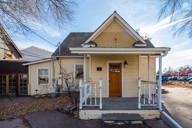
Property Record
210 Franklin St, Niwot, CO 80544


Property Detail
210 Franklin St
1317254-07-010
LOTS 13-14-15 BLK 21 NIWOT
Commercialnec
Boulder
RC
Colorado
B and X Area of moderate flood hazard, usually the area between the limits of the 100-year and 500-year floods.
13
2024
0.23 AC
2025
Longmont
013205
Denver
1,786 SF
Boulder, CO
NEARBY LISTINGS FOR SALE OR LEASE
DEMOGRAPHICS near 210 Franklin St
1 mile
3 mile
5 mile
2024 Total Population
2,719
19,584
46,543
2029 Population
2,731
19,471
46,405
Pop Growth 2024-2029
+ 0.44%
(0.58%)
(0.30%)
Average Age
47
43
42
2024 Total Households
1,099
7,997
18,716
HH Growth 2024-2029
+ 0.27%
(0.96%)
(0.48%)
Median Household Inc
$142,766
$137,959
$114,486
Avg Household Size
2.30
2.40
2.40
2024 Avg HH Vehicles
2.00
2.00
2.00
Median Home Value
$939,075
$856,277
$793,460
Median Year Built
1983
1995
1992
Nearby Places
Map Layers
Map Styles
 Street
 Aerial
Transit
 Traffic
 Biking
Places
Listings with unknown addresses are not visible on the map
- Restaurants
- Banks
- Shops
- Fitness
- Groceries
PUBLIC TRANSPORTATION
AIRPORT
Denver International
Drive
Walk
Distance
Denver International
56 min
43.0 mi
SALE & LEASE HISTORY
LISTING DATE
SALE/LEASE

Oct 28, 2024
For Lease
Jul 19, 2019
For Sale
Jan 10, 2022
For Lease
Feb 10, 2025
For Sale
Dec 28, 2022
For Lease
Apr 20, 2023
For Sale
Nearby Properties
Address
Land Use
TOTAL SIZE
Lot Size
Zoning
Address
Land Use
TOTAL SIZE
Lot Size
Zoning
17.51 AC
Address
Land Use
TOTAL SIZE
Lot Size
Zoning
155.96 AC
Address
Land Use
TOTAL SIZE
Lot Size
Zoning
141.82 AC
A
Address
Land Use
TOTAL SIZE
Lot Size
Zoning
2,696,002 SF
344.44 AC
Address
Land Use
TOTAL SIZE
Lot Size
Zoning
97.48 AC
A
Address
Land Use
TOTAL SIZE
Lot Size
Zoning
239.52 AC
A
Address
Land Use
TOTAL SIZE
Lot Size
Zoning
621 SF
118.25 AC
A
Address
Land Use
TOTAL SIZE
Lot Size
Zoning
174.57 AC
A
Address
Land Use
TOTAL SIZE
Lot Size
Zoning
306.20 AC
A
Address
Land Use
TOTAL SIZE
Lot Size
Zoning
4,048 SF
158.20 AC
A
Address
Land Use
TOTAL SIZE
Lot Size
Zoning
158.31 AC
Address
Land Use
TOTAL SIZE
Lot Size
Zoning
147.13 AC
A
Address
Land Use
TOTAL SIZE
Lot Size
Zoning
161.08 AC
A
Address
Land Use
TOTAL SIZE
Lot Size
Zoning
158.19 AC
A
Address
Land Use
TOTAL SIZE
Lot Size
Zoning
159.19 AC
A
Address
Land Use
TOTAL SIZE
Lot Size
Zoning
223,669 SF
14.27 AC
Address
Land Use
TOTAL SIZE
Lot Size
Zoning
304,116 SF
23.66 AC
MF
Address
Land Use
TOTAL SIZE
Lot Size
Zoning
56,673 SF
35.16 AC
A
Address
Land Use
TOTAL SIZE
Lot Size
Zoning
34.29 AC
A
Address
Land Use
TOTAL SIZE
Lot Size
Zoning
267.15 AC
RR
Address
Land Use
TOTAL SIZE
Lot Size
Zoning
33.28 AC
A
Address
Land Use
TOTAL SIZE
Lot Size
Zoning
1,072,030 SF
119.89 AC
Address
Land Use
TOTAL SIZE
Lot Size
Zoning
80.83 AC
A
Address
Land Use
TOTAL SIZE
Lot Size
Zoning
79.23 AC
A
Address
Land Use
TOTAL SIZE
Lot Size
Zoning
79.45 AC
A
Address
Land Use
TOTAL SIZE
Lot Size
Zoning
76.35 AC
A
Address
Land Use
TOTAL SIZE
Lot Size
Zoning
76.33 AC
A
Address
Land Use
TOTAL SIZE
Lot Size
Zoning
74.26 AC
A
Address
Land Use
TOTAL SIZE
Lot Size
Zoning
73.97 AC
Address
Land Use
TOTAL SIZE
Lot Size
Zoning
33.11 AC
A
The World's #1 Commercial Real Estate Marketplace
Connect with us
© 2026 CoStar Group
The information above has been obtained from sources believed reliable. While we do not doubt its accuracy we have not verified it and make no guarantee, warranty or representation about it. It is your responsibility to independently confirm its accuracy and completeness. Any projections, opinions, assumptions, or estimates used are for example only and do not represent the current or future performance of the property. The value of this transaction to you depends on tax and other factors which should be evaluated by your tax, financial, and legal advisors. You and your advisors should conduct a careful, independent investigation of the property to determine to your satisfaction the suitability of the property for your needs.