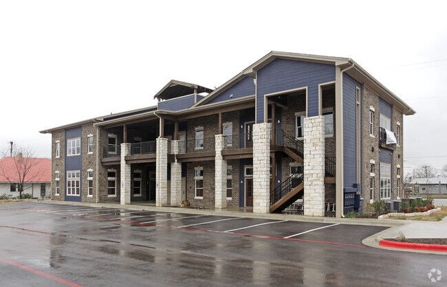
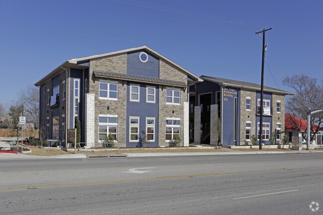
Property Record
210 Highway 79, Hutto, TX 78634

Property Detail
210 Highway 79
Austin-Round Rock-San Marcos, TX
S9796 - 210 HIGHWAY 79 EAST, BLOCK 15, LOT B, ACRES 0.525
R499735
Williamson
Commercialnec
Texas
C and X Area of minimal flood hazard, usually depicted on FIRMs as above the 500-year flood level.
b
2024
0.53 AC
2025
Georgetown
020813
Austin
7,454 SF
NEARBY LISTINGS FOR SALE OR LEASE
DEMOGRAPHICS near 210 Highway 79
1 mile
3 mile
5 mile
2025 Total Population
10,196
41,490
96,073
2030 Population
11,865
48,368
109,757
Pop Growth 2025-2030
+ 16.37%
+ 16.58%
+ 14.24%
Average Age
36
35
36
2025 Total Households
3,259
13,252
31,305
HH Growth 2025-2030
+ 16.94%
+ 16.98%
+ 14.78%
Median Household Inc
$119,185
$120,628
$132,303
Avg Household Size
3.10
3.10
3.00
2025 Avg HH Vehicles
3.00
2.00
2.00
Median Home Value
$374,725
$400,583
$447,372
Median Year Built
2008
2010
2010
Nearby Places
Map Layers
Map Styles
 Street
 Aerial
Transit
 Traffic
 Biking
Places
Listings with unknown addresses are not visible on the map
- Restaurants
- Banks
- Shops
- Fitness
- Groceries
PUBLIC TRANSPORTATION
COMMUTER RAIL
Taylor Amtrak (Texas Eagle - Amtrak)
Drive
Walk
Distance
Taylor Amtrak (Texas Eagle - Amtrak)
11 min
8.4 mi
AIRPORT
Austin-Bergstrom International
Drive
Walk
Distance
Austin-Bergstrom International
42 min
33.2 mi
Freight Ports
Calhoun Port
Drive
Walk
Distance
Calhoun Port
203 min
176.1 mi
SALE & LEASE HISTORY
LISTING DATE
SALE/LEASE

Sep 23, 2016
For Sale
Mar 09, 2018
For Sale
Jul 25, 2018
For Lease
Dec 01, 2017
For Lease
Nearby Properties
Address
Land Use
TOTAL SIZE
Lot Size
Zoning
Address
Land Use
TOTAL SIZE
Lot Size
Zoning
243,097 SF
15.73 AC
Address
Land Use
TOTAL SIZE
Lot Size
Zoning
302,465 SF
15.79 AC
Address
Land Use
TOTAL SIZE
Lot Size
Zoning
253,225 SF
12.25 AC
Address
Land Use
TOTAL SIZE
Lot Size
Zoning
301,721 SF
16.54 AC
Address
Land Use
TOTAL SIZE
Lot Size
Zoning
304,814 SF
17.04 AC
Address
Land Use
TOTAL SIZE
Lot Size
Zoning
308,759 SF
13.93 AC
Address
Land Use
TOTAL SIZE
Lot Size
Zoning
76.14 AC
Address
Land Use
TOTAL SIZE
Lot Size
Zoning
230,841 SF
17.51 AC
Address
Land Use
TOTAL SIZE
Lot Size
Zoning
183,310 SF
10.78 AC
Address
Land Use
TOTAL SIZE
Lot Size
Zoning
338,229 SF
15.38 AC
Address
Land Use
TOTAL SIZE
Lot Size
Zoning
195,520 SF
14.89 AC
Address
Land Use
TOTAL SIZE
Lot Size
Zoning
243,097 SF
12.53 AC
Address
Land Use
TOTAL SIZE
Lot Size
Zoning
154,528 SF
7.23 AC
Address
Land Use
TOTAL SIZE
Lot Size
Zoning
220,850 SF
12.06 AC
Address
Land Use
TOTAL SIZE
Lot Size
Zoning
161,190 SF
8.82 AC
Address
Land Use
TOTAL SIZE
Lot Size
Zoning
297,577 SF
28.22 AC
Address
Land Use
TOTAL SIZE
Lot Size
Zoning
535,408 SF
30.16 AC
Address
Land Use
TOTAL SIZE
Lot Size
Zoning
147,230 SF
8.05 AC
Address
Land Use
TOTAL SIZE
Lot Size
Zoning
109,908 SF
7.94 AC
Address
Land Use
TOTAL SIZE
Lot Size
Zoning
16.70 AC
Address
Land Use
TOTAL SIZE
Lot Size
Zoning
14.30 AC
Address
Land Use
TOTAL SIZE
Lot Size
Zoning
193,933 SF
14.25 AC
Address
Land Use
TOTAL SIZE
Lot Size
Zoning
108,422 SF
15.72 AC
Address
Land Use
TOTAL SIZE
Lot Size
Zoning
35,187 SF
5.57 AC
Address
Land Use
TOTAL SIZE
Lot Size
Zoning
154,752 SF
0.90 AC
Address
Land Use
TOTAL SIZE
Lot Size
Zoning
140,233 SF
12.63 AC
Address
Land Use
TOTAL SIZE
Lot Size
Zoning
114,374 SF
15 AC
Address
Land Use
TOTAL SIZE
Lot Size
Zoning
21,183 SF
3.70 AC
Address
Land Use
TOTAL SIZE
Lot Size
Zoning
108,594 SF
3.18 AC
Address
Land Use
TOTAL SIZE
Lot Size
Zoning
74,525 SF
8.10 AC
The World's #1 Commercial Real Estate Marketplace
Connect with us
© 2026 CoStar Group
The information above has been obtained from sources believed reliable. While we do not doubt its accuracy we have not verified it and make no guarantee, warranty or representation about it. It is your responsibility to independently confirm its accuracy and completeness. Any projections, opinions, assumptions, or estimates used are for example only and do not represent the current or future performance of the property. The value of this transaction to you depends on tax and other factors which should be evaluated by your tax, financial, and legal advisors. You and your advisors should conduct a careful, independent investigation of the property to determine to your satisfaction the suitability of the property for your needs.