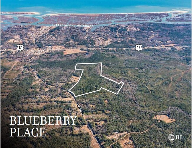
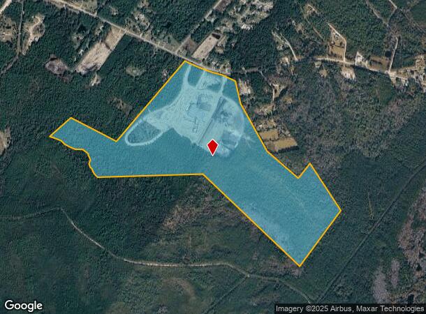
Property Record
1481 Nc Highway 210 W, Hampstead, NC 28443
NEARBY LISTINGS FOR SALE OR LEASE
Property Detail
1481 Nc Highway 210 W
3282-28-1109-0000
ON B/S 210 N/W HAMPSTEAD
Vacantlandnec
Pender
X
North Carolina
3720328200J
145 AC
0
East Pender County
2025
Wilmington
920203
Wilmington, NC
DEMOGRAPHICS near 1481 Nc Highway 210 W
1 mile
3 mile
5 mile
2024 Total Population
464
10,538
18,763
2029 Population
572
12,902
22,797
Pop Growth 2024-2029
+ 23.28%
+ 22.43%
+ 21.50%
Average Age
41
40
42
2024 Total Households
195
3,928
7,164
HH Growth 2024-2029
+ 23.59%
+ 22.68%
+ 21.64%
Median Household Inc
$89,285
$103,687
$98,231
Avg Household Size
2.40
2.70
2.60
2024 Avg HH Vehicles
2.00
2.00
2.00
Median Home Value
$316,071
$317,742
$322,936
Median Year Built
2004
2004
2002
Nearby Places
Map Layers
Map Styles
 Street
 Aerial
Transit
 Traffic
 Biking
Places
Listings with unknown addresses are not visible on the map
- Restaurants
- Banks
- Shops
- Fitness
- Groceries
PUBLIC TRANSPORTATION
AIRPORT
Wilmington International
Drive
Walk
Distance
Wilmington International
31 min
17.7 mi
Freight Ports
Port of Wilmington
Drive
Walk
Distance
Port of Wilmington
39 min
25.3 mi
SALE & LEASE HISTORY
LISTING DATE
SALE/LEASE

Nov 11, 2022
For Sale
Nearby Properties
Address
Land Use
TOTAL SIZE
Lot Size
Zoning
Address
Land Use
TOTAL SIZE
Lot Size
Zoning
80,712 SF
16.69 AC
Address
Land Use
TOTAL SIZE
Lot Size
Zoning
90,501 SF
7.03 AC
GB
Address
Land Use
TOTAL SIZE
Lot Size
Zoning
6,364 SF
11.40 AC
R20
Address
Land Use
TOTAL SIZE
Lot Size
Zoning
45,636 SF
6.45 AC
GB
Address
Land Use
TOTAL SIZE
Lot Size
Zoning
49,000 SF
4.29 AC
Address
Land Use
TOTAL SIZE
Lot Size
Zoning
24,000 SF
2.79 AC
B2
Address
Land Use
TOTAL SIZE
Lot Size
Zoning
16,748 SF
6.26 AC
SEEMAP
Address
Land Use
TOTAL SIZE
Lot Size
Zoning
4,565 SF
0.82 AC
SEEMAP
Address
Land Use
TOTAL SIZE
Lot Size
Zoning
2,035 SF
2.10 AC
SEEMAP
Address
Land Use
TOTAL SIZE
Lot Size
Zoning
11,828 SF
1 AC
Address
Land Use
TOTAL SIZE
Lot Size
Zoning
3,372 SF
0.75 AC
SEEMAP
Address
Land Use
TOTAL SIZE
Lot Size
Zoning
1,324.37 AC
RA
Address
Land Use
TOTAL SIZE
Lot Size
Zoning
6,000 SF
1,199 AC
RA
Address
Land Use
TOTAL SIZE
Lot Size
Zoning
25,000 SF
1.96 AC
SEEMAP
Address
Land Use
TOTAL SIZE
Lot Size
Zoning
21,807 SF
9.76 AC
SEEMAP
Address
Land Use
TOTAL SIZE
Lot Size
Zoning
4,858 SF
7.20 AC
SEEMAP
Address
Land Use
TOTAL SIZE
Lot Size
Zoning
2,978 SF
0.78 AC
SEEMAP
Address
Land Use
TOTAL SIZE
Lot Size
Zoning
8,120 SF
15.73 AC
SEEMAP
Address
Land Use
TOTAL SIZE
Lot Size
Zoning
Address
Land Use
TOTAL SIZE
Lot Size
Zoning
11,359 SF
27.96 AC
Address
Land Use
TOTAL SIZE
Lot Size
Zoning
11,852 SF
0.45 AC
B2
Address
Land Use
TOTAL SIZE
Lot Size
Zoning
2,735 SF
1 AC
FADASH
Address
Land Use
TOTAL SIZE
Lot Size
Zoning
4,900 SF
0.88 AC
SEEMAP
Address
Land Use
TOTAL SIZE
Lot Size
Zoning
41.76 AC
GB
Address
Land Use
TOTAL SIZE
Lot Size
Zoning
12,000 SF
4.30 AC
SEEMAP
Address
Land Use
TOTAL SIZE
Lot Size
Zoning
1,575 SF
0.69 AC
SEEMAP
Address
Land Use
TOTAL SIZE
Lot Size
Zoning
3,749 SF
0.47 AC
FADASH
Address
Land Use
TOTAL SIZE
Lot Size
Zoning
5,036 SF
1.32 AC
FADASH
The World's #1 Commercial Real Estate Marketplace
Connect with us
© 2026 CoStar Group
The information above has been obtained from sources believed reliable. While we do not doubt its accuracy we have not verified it and make no guarantee, warranty or representation about it. It is your responsibility to independently confirm its accuracy and completeness. Any projections, opinions, assumptions, or estimates used are for example only and do not represent the current or future performance of the property. The value of this transaction to you depends on tax and other factors which should be evaluated by your tax, financial, and legal advisors. You and your advisors should conduct a careful, independent investigation of the property to determine to your satisfaction the suitability of the property for your needs.