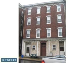
Property Record
210 Main St, King Of Prussia, PA 19406
NEARBY LISTINGS FOR SALE OR LEASE
Property Detail
210 Main St
19-00-01940-003
ASSESSOR BLOCK-UNIT NUMBER 11-3
Commercialnec
Montgomery
X
Pennsylvania
42029C0060G
3
2024
0.09 AC
2025
Upper Montgomery County
205811
Philadelphia
6,304 SF
Philadelphia-Camden-Wilmington, PA-NJ-DE-MD
DEMOGRAPHICS near 210 Main St
1 Mile
3 Mile
5 Mile
2024 Total Population
12,239
38,558
110,200
2029 Population
12,598
39,680
113,461
Pop Growth 2024-2029
+ 2.93%
+ 2.91%
+ 2.96%
Average Age
40
40
40
2024 Total Households
5,428
14,793
42,640
HH Growth 2024-2029
+ 3.02%
+ 2.95%
+ 3.09%
Median Household Inc
$71,168
$95,086
$104,211
Avg Household Size
2.20
2.50
2.50
2024 Avg HH Vehicles
2.00
2.00
2.00
Median Home Value
$238,678
$354,356
$360,146
Median Year Built
1958
1985
1986
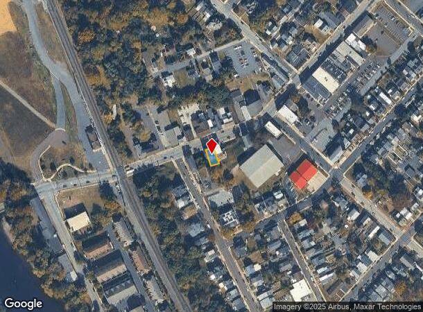
Nearby Places
Map Layers
Map Styles
 Street
 Aerial
- Restaurants
- Banks
- Shops
- Fitness
- Groceries
PUBLIC TRANSPORTATION
AIRPORT
Philadelphia International
DRIVE
WALK
Distance
Philadelphia International
60 min
39.7 mi
Freight Ports
South Jersey Port
DRIVE
WALK
Distance
South Jersey Port
54 min
35.8 mi
Nearby Properties
Address
Land Use
TOTAL SIZE
Lot Size
Zoning
Address
Land Use
TOTAL SIZE
Lot Size
Zoning
208,637 SF
13.37 AC
AG
Address
Land Use
TOTAL SIZE
Lot Size
Zoning
463,481 SF
79.65 AC
R1
Address
Land Use
TOTAL SIZE
Lot Size
Zoning
416,228 SF
18.24 AC
R3
Address
Land Use
TOTAL SIZE
Lot Size
Zoning
368,083 SF
126.15 AC
R2
Address
Land Use
TOTAL SIZE
Lot Size
Zoning
217,154 SF
77.97 AC
R1
Address
Land Use
TOTAL SIZE
Lot Size
Zoning
347,779 SF
32.59 AC
IN
Address
Land Use
TOTAL SIZE
Lot Size
Zoning
268,366 SF
32.55 AC
R4
Address
Land Use
TOTAL SIZE
Lot Size
Zoning
271,556 SF
38.87 AC
R4
Address
Land Use
TOTAL SIZE
Lot Size
Zoning
407,301 SF
8.04 AC
ARU
Address
Land Use
TOTAL SIZE
Lot Size
Zoning
233,630 SF
15 AC
R4
Address
Land Use
TOTAL SIZE
Lot Size
Zoning
125,788 SF
24.83 AC
R1
Address
Land Use
TOTAL SIZE
Lot Size
Zoning
97,188 SF
13.13 AC
OLI
Address
Land Use
TOTAL SIZE
Lot Size
Zoning
134,334 SF
21.95 AC
RB
Address
Land Use
TOTAL SIZE
Lot Size
Zoning
68,378 SF
27 AC
R3
Address
Land Use
TOTAL SIZE
Lot Size
Zoning
137,596 SF
41 AC
IN
Address
Land Use
TOTAL SIZE
Lot Size
Zoning
98,208 SF
2.26 AC
CRSC
Address
Land Use
TOTAL SIZE
Lot Size
Zoning
222,272 SF
21.60 AC
OLI
Address
Land Use
TOTAL SIZE
Lot Size
Zoning
83,186 SF
11.81 AC
CRSC
Address
Land Use
TOTAL SIZE
Lot Size
Zoning
83,629 SF
7.29 AC
R2
Address
Land Use
TOTAL SIZE
Lot Size
Zoning
80,565 SF
9.82 AC
IN
Address
Land Use
TOTAL SIZE
Lot Size
Zoning
136,807 SF
3 AC
R2
Address
Land Use
TOTAL SIZE
Lot Size
Zoning
68,775 SF
14.91 AC
OLI
Address
Land Use
TOTAL SIZE
Lot Size
Zoning
69,816 SF
2.95 AC
RB
Address
Land Use
TOTAL SIZE
Lot Size
Zoning
115,054 SF
6.97 AC
R12
Address
Land Use
TOTAL SIZE
Lot Size
Zoning
122,956 SF
10.67 AC
CRSC
Address
Land Use
TOTAL SIZE
Lot Size
Zoning
39,310 SF
4.63 AC
OLI
Address
Land Use
TOTAL SIZE
Lot Size
Zoning
3,120 SF
176.40 AC
IN
Address
Land Use
TOTAL SIZE
Lot Size
Zoning
12,382 SF
10.13 AC
OLI
Address
Land Use
TOTAL SIZE
Lot Size
Zoning
165,111 SF
15.87 AC
OLI
Address
Land Use
TOTAL SIZE
Lot Size
Zoning
5.30 AC
R2
The World's #1 Commercial Real Estate Marketplace
Connect with us
© 2025 CoStar Group
The information above has been obtained from sources believed reliable. While we do not doubt its accuracy we have not verified it and make no guarantee, warranty or representation about it. It is your responsibility to independently confirm its accuracy and completeness. Any projections, opinions, assumptions, or estimates used are for example only and do not represent the current or future performance of the property. The value of this transaction to you depends on tax and other factors which should be evaluated by your tax, financial, and legal advisors. You and your advisors should conduct a careful, independent investigation of the property to determine to your satisfaction the suitability of the property for your needs.