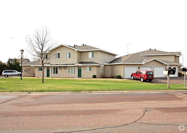
Property Record
210 Maple Ln, Big Lake, MN 55309

NEARBY LISTINGS FOR SALE OR LEASE
-
-
View all Big Lake listings for sale on LoopNet.com
Property Detail
210 Maple Ln
Minneapolis-St. Paul-Bloomington, MN-WI
James L. Mckeen Second Addition
65-449-0131
THAT PT OF LOT 24, BLK 1 THAT LIES SLY OF FOLLOWING DES LINE: BEG AT THE MOST ELY COR OF LOT 24, THENCE WLY 202.26 FT TO MOST WLY COR OF LOT 24 & SAID LINE TERMINATING. AND THAT PT OF LOT 17, BLK 1 THAT LINE ELY OF FOLLOWING DES LINE: COM AT MOST WLY
Welfaresocialservicelowincomehousingexempt
Sherburne
X
Minnesota
27141C0335F
17,24
2025
3.21 AC
2025
Clemens & Munsinger Gardens
030409
Minneapolis/St Paul
DEMOGRAPHICS near 210 Maple Ln
1 Mile
3 Mile
5 Mile
2024 Total Population
2,692
20,146
38,909
2029 Population
2,935
22,161
42,943
Pop Growth 2024-2029
+ 9.03%
+ 10.00%
+ 10.37%
Average Age
38
36
36
2024 Total Households
1,009
7,359
13,858
HH Growth 2024-2029
+ 9.12%
+ 10.15%
+ 10.50%
Median Household Inc
$81,565
$87,956
$94,428
Avg Household Size
2.60
2.70
2.80
2024 Avg HH Vehicles
2.00
2.00
2.00
Median Home Value
$222,860
$262,403
$273,367
Median Year Built
1987
1992
1994
Nearby Places
Map Layers
Map Styles
 Street
 Aerial
- Restaurants
- Banks
- Shops
- Fitness
- Groceries
PUBLIC TRANSPORTATION
COMMUTER RAIL
Big Lake Station (Northstar Corridor - Northstar Commuter Rail)
DRIVE
WALK
Distance
Big Lake Station (Northstar Corridor - Northstar Commuter Rail)
7 min
2.4 mi
Freight Ports
Port Milwaukee
DRIVE
WALK
Distance
Port Milwaukee
420 min
377.0 mi
Nearby Properties
Address
Land Use
TOTAL SIZE
Lot Size
Zoning
Address
Land Use
TOTAL SIZE
Lot Size
Zoning
240 SF
129.53 AC
Address
Land Use
TOTAL SIZE
Lot Size
Zoning
30,281 SF
27.77 AC
Address
Land Use
TOTAL SIZE
Lot Size
Zoning
207,895 SF
26.76 AC
Address
Land Use
TOTAL SIZE
Lot Size
Zoning
105,842 SF
36.08 AC
Address
Land Use
TOTAL SIZE
Lot Size
Zoning
88,227 SF
2.95 AC
Address
Land Use
TOTAL SIZE
Lot Size
Zoning
141,593 SF
18.15 AC
Address
Land Use
TOTAL SIZE
Lot Size
Zoning
119,837 SF
5.04 AC
Address
Land Use
TOTAL SIZE
Lot Size
Zoning
160 SF
17.83 AC
Address
Land Use
TOTAL SIZE
Lot Size
Zoning
174,200 SF
14.09 AC
Address
Land Use
TOTAL SIZE
Lot Size
Zoning
15,300 SF
0.55 AC
Address
Land Use
TOTAL SIZE
Lot Size
Zoning
4.72 AC
Address
Land Use
TOTAL SIZE
Lot Size
Zoning
2.63 AC
Address
Land Use
TOTAL SIZE
Lot Size
Zoning
69,747 SF
2.08 AC
Address
Land Use
TOTAL SIZE
Lot Size
Zoning
50,900 SF
17.86 AC
Address
Land Use
TOTAL SIZE
Lot Size
Zoning
88,970 SF
12.79 AC
Address
Land Use
TOTAL SIZE
Lot Size
Zoning
69,500 SF
3.50 AC
Address
Land Use
TOTAL SIZE
Lot Size
Zoning
58,898 SF
0.78 AC
Address
Land Use
TOTAL SIZE
Lot Size
Zoning
1.22 AC
Address
Land Use
TOTAL SIZE
Lot Size
Zoning
105,255 SF
10.39 AC
Address
Land Use
TOTAL SIZE
Lot Size
Zoning
720 SF
52.42 AC
Address
Land Use
TOTAL SIZE
Lot Size
Zoning
60,432 SF
0.76 AC
Address
Land Use
TOTAL SIZE
Lot Size
Zoning
49,234 SF
20.74 AC
Address
Land Use
TOTAL SIZE
Lot Size
Zoning
12,960 SF
3.81 AC
Address
Land Use
TOTAL SIZE
Lot Size
Zoning
13,200 SF
57.14 AC
I
Address
Land Use
TOTAL SIZE
Lot Size
Zoning
4.50 AC
Address
Land Use
TOTAL SIZE
Lot Size
Zoning
7,600 SF
16.16 AC
Address
Land Use
TOTAL SIZE
Lot Size
Zoning
2.49 AC
Address
Land Use
TOTAL SIZE
Lot Size
Zoning
154,440 SF
21.53 AC
A
Address
Land Use
TOTAL SIZE
Lot Size
Zoning
416 SF
6.91 AC
Address
Land Use
TOTAL SIZE
Lot Size
Zoning
108,986 SF
9.39 AC
The World's #1 Commercial Real Estate Marketplace
Connect with us
© 2026 CoStar Group
The information above has been obtained from sources believed reliable. While we do not doubt its accuracy we have not verified it and make no guarantee, warranty or representation about it. It is your responsibility to independently confirm its accuracy and completeness. Any projections, opinions, assumptions, or estimates used are for example only and do not represent the current or future performance of the property. The value of this transaction to you depends on tax and other factors which should be evaluated by your tax, financial, and legal advisors. You and your advisors should conduct a careful, independent investigation of the property to determine to your satisfaction the suitability of the property for your needs.