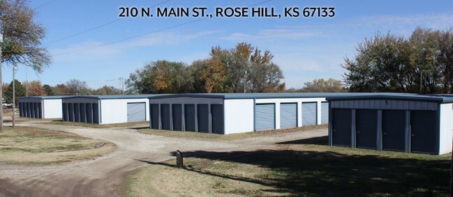
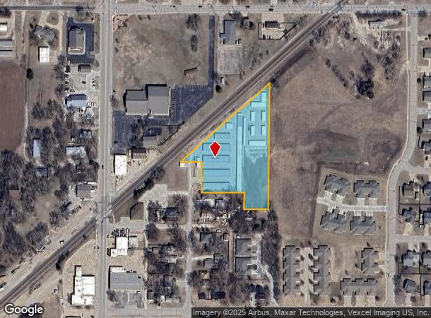
Property Record
210 N Main St, Rose Hill, KS 67133

NEARBY LISTINGS FOR SALE OR LEASE
-
-
View all Rose Hill listings for sale on LoopNet.com
Property Detail
210 N Main St
Wichita, KS
Evans 1St Add
423-05-0-20-04-005-00-0
EVANS 1ST ADD, S05, T29, R03E, ACRES 2.6, LT 1-3 BLK 1 EVANS 1ST ADD; LT 4 EXC W35 S75 BLK 1 HERITAGE ADD; PT LT 9 BEG NE/C L
Publicstorage
Butler
X
Kansas
20173C0545G
1-4,9
2024
2.60 AC
2025
Derby/Haysville/Mulvane
020902
Wichita
7,200 SF
DEMOGRAPHICS near 210 N Main St
1 Mile
3 Mile
5 Mile
2024 Total Population
3,005
5,598
8,537
2029 Population
3,077
5,703
8,660
Pop Growth 2024-2029
+ 2.40%
+ 1.88%
+ 1.44%
Average Age
38
39
41
2024 Total Households
1,036
1,950
3,029
HH Growth 2024-2029
+ 2.51%
+ 1.90%
+ 1.45%
Median Household Inc
$93,080
$96,939
$100,379
Avg Household Size
2.80
2.80
2.70
2024 Avg HH Vehicles
3.00
3.00
3.00
Median Home Value
$167,614
$191,569
$228,506
Median Year Built
1990
1990
1990
Nearby Places
Map Layers
Map Styles
 Street
 Aerial
- Restaurants
- Banks
- Shops
- Fitness
- Groceries
PUBLIC TRANSPORTATION
AIRPORT
Wichita Dwight D Eisenhower Ntl
DRIVE
WALK
Distance
Wichita Dwight D Eisenhower Ntl
39 min
24.9 mi
Freight Ports
Tulsa Port Of Catoosa
DRIVE
WALK
Distance
Tulsa Port Of Catoosa
217 min
194.1 mi
SALE & LEASE HISTORY
LISTING DATE
SALE/LEASE

Nov 14, 2018
For Sale
Nearby Properties
Address
Land Use
TOTAL SIZE
Lot Size
Zoning
Address
Land Use
TOTAL SIZE
Lot Size
Zoning
97.20 AC
Address
Land Use
TOTAL SIZE
Lot Size
Zoning
279,330 SF
40.10 AC
Address
Land Use
TOTAL SIZE
Lot Size
Zoning
2,560 SF
103.70 AC
Address
Land Use
TOTAL SIZE
Lot Size
Zoning
10,895 SF
2 AC
Address
Land Use
TOTAL SIZE
Lot Size
Zoning
13,318 SF
1.70 AC
Address
Land Use
TOTAL SIZE
Lot Size
Zoning
18,996 SF
5.30 AC
Address
Land Use
TOTAL SIZE
Lot Size
Zoning
15,186 SF
9.70 AC
Address
Land Use
TOTAL SIZE
Lot Size
Zoning
7,424 SF
3.80 AC
Address
Land Use
TOTAL SIZE
Lot Size
Zoning
6,554 SF
2.50 AC
Address
Land Use
TOTAL SIZE
Lot Size
Zoning
6,492 SF
2.40 AC
Address
Land Use
TOTAL SIZE
Lot Size
Zoning
0.96 AC
Address
Land Use
TOTAL SIZE
Lot Size
Zoning
7,560 SF
1.80 AC
Address
Land Use
TOTAL SIZE
Lot Size
Zoning
61,650 SF
5 AC
Address
Land Use
TOTAL SIZE
Lot Size
Zoning
1,200 SF
21.40 AC
Address
Land Use
TOTAL SIZE
Lot Size
Zoning
4,923 SF
1 AC
Address
Land Use
TOTAL SIZE
Lot Size
Zoning
9,684 SF
0.43 AC
Address
Land Use
TOTAL SIZE
Lot Size
Zoning
11,918 SF
2 AC
Address
Land Use
TOTAL SIZE
Lot Size
Zoning
5,720 SF
0.73 AC
Address
Land Use
TOTAL SIZE
Lot Size
Zoning
17.10 AC
Address
Land Use
TOTAL SIZE
Lot Size
Zoning
33,718 SF
5.50 AC
Address
Land Use
TOTAL SIZE
Lot Size
Zoning
4,100 SF
1.10 AC
Address
Land Use
TOTAL SIZE
Lot Size
Zoning
2,520 SF
0.44 AC
Address
Land Use
TOTAL SIZE
Lot Size
Zoning
2.30 AC
Address
Land Use
TOTAL SIZE
Lot Size
Zoning
861 SF
1 AC
Address
Land Use
TOTAL SIZE
Lot Size
Zoning
11,014 SF
1.80 AC
Address
Land Use
TOTAL SIZE
Lot Size
Zoning
18.70 AC
Address
Land Use
TOTAL SIZE
Lot Size
Zoning
8,970 SF
1.10 AC
Address
Land Use
TOTAL SIZE
Lot Size
Zoning
12,646 SF
1.50 AC
Address
Land Use
TOTAL SIZE
Lot Size
Zoning
4,672 SF
0.64 AC
The World's #1 Commercial Real Estate Marketplace
Connect with us
© 2025 CoStar Group
The information above has been obtained from sources believed reliable. While we do not doubt its accuracy we have not verified it and make no guarantee, warranty or representation about it. It is your responsibility to independently confirm its accuracy and completeness. Any projections, opinions, assumptions, or estimates used are for example only and do not represent the current or future performance of the property. The value of this transaction to you depends on tax and other factors which should be evaluated by your tax, financial, and legal advisors. You and your advisors should conduct a careful, independent investigation of the property to determine to your satisfaction the suitability of the property for your needs.