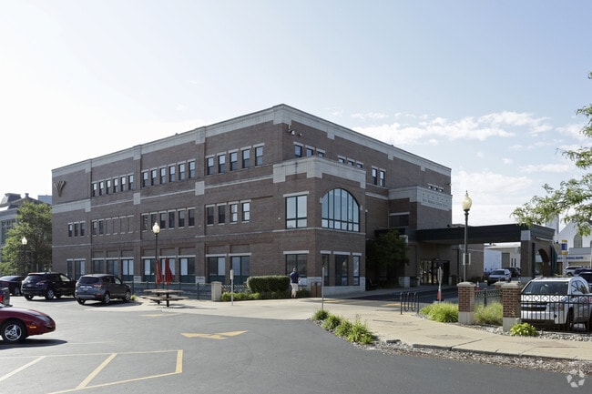
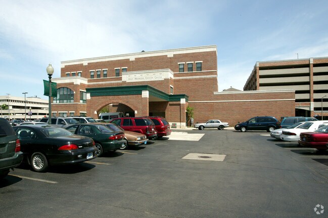
Property Record
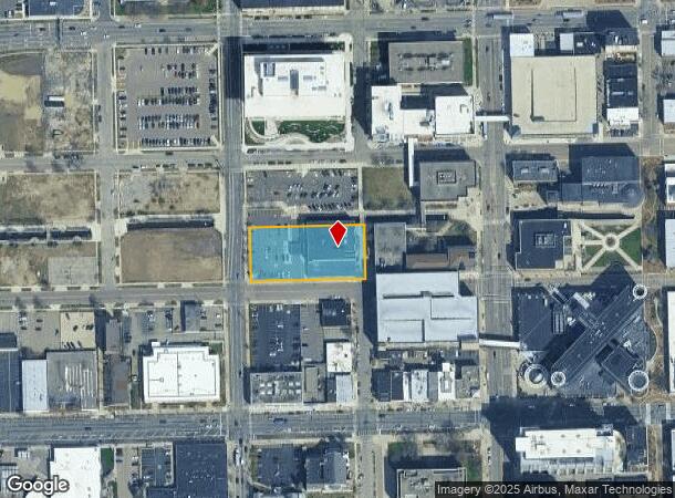
210 N Park St, Kalamazoo, MI 49007
NEARBY LISTINGS FOR SALE OR LEASE
-
-
-
-
-
No Photo
-
-
-
View all Kalamazoo listings for sale on LoopNet.com
Property Detail
210 N Park St
06-15-323-005
Original - City Of Kalamazoo
Commercialnec
SW 1/4 SECTION 15-2-11 BEG AT SW COR BLK 3 PLAT OF TOWN, NOW CITY, OF KALAMAZOO; TH S 89 DEG 59 MIN 41 SEC E, 300.97' ALG S
X
Kalamazoo
26077C0187E
Michigan
0
0.96 AC
2025
Central Kalamazoo
000201
West Michigan
42,995 SF
Kalamazoo-Portage, MI
DEMOGRAPHICS near 210 N Park St
1 Mile
3 Mile
5 Mile
2024 Total Population
13,906
82,287
145,809
2029 Population
14,144
82,483
145,843
Pop Growth 2024-2029
+ 1.71%
+ 0.24%
+ 0.02%
Average Age
34
34
36
2024 Total Households
6,121
33,065
61,658
HH Growth 2024-2029
+ 1.85%
+ 0.27%
+ 0.02%
Median Household Inc
$32,222
$44,342
$49,300
Avg Household Size
2.00
2.20
2.20
2024 Avg HH Vehicles
1.00
2.00
2.00
Median Home Value
$113,591
$144,416
$164,611
Median Year Built
1947
1957
1968
Nearby Places
Map Layers
Map Styles
 Street
 Aerial
- Restaurants
- Banks
- Shops
- Fitness
- Groceries
PUBLIC TRANSPORTATION
AIRPORT
Kalamazoo/Battle Creek International
DRIVE
WALK
Distance
Kalamazoo/Battle Creek International
13 min
5.3 mi
Freight Ports
Port of Baltimore
DRIVE
WALK
Distance
Port of Baltimore
1 min
514.5 mi
Nearby Properties
Address
Land Use
TOTAL SIZE
Lot Size
Zoning
Address
Land Use
TOTAL SIZE
Lot Size
Zoning
632,218 SF
10.84 AC
M-1
Address
Land Use
TOTAL SIZE
Lot Size
Zoning
374,906 SF
16.31 AC
RM-36
Address
Land Use
TOTAL SIZE
Lot Size
Zoning
329,276 SF
43.86 AC
RM-1
Address
Land Use
TOTAL SIZE
Lot Size
Zoning
429,500 SF
2 AC
CCBD
Address
Land Use
TOTAL SIZE
Lot Size
Zoning
315,422 SF
25.40 AC
RM-15
Address
Land Use
TOTAL SIZE
Lot Size
Zoning
877,422 SF
38.18 AC
M-2
Address
Land Use
TOTAL SIZE
Lot Size
Zoning
105,046 SF
19.30 AC
RM-15
Address
Land Use
TOTAL SIZE
Lot Size
Zoning
273,122 SF
16.12 AC
PUD
Address
Land Use
TOTAL SIZE
Lot Size
Zoning
201,940 SF
9.30 AC
RM-36
Address
Land Use
TOTAL SIZE
Lot Size
Zoning
110,686 SF
9.45 AC
CCBD
Address
Land Use
TOTAL SIZE
Lot Size
Zoning
390,900 SF
14 AC
I-M IND
Address
Land Use
TOTAL SIZE
Lot Size
Zoning
134,876 SF
16.45 AC
RM-15
Address
Land Use
TOTAL SIZE
Lot Size
Zoning
275,595 SF
0.65 AC
CCBD
Address
Land Use
TOTAL SIZE
Lot Size
Zoning
Address
Land Use
TOTAL SIZE
Lot Size
Zoning
50,826 SF
0.79 AC
CCBD
Address
Land Use
TOTAL SIZE
Lot Size
Zoning
186,652 SF
28.29 AC
PUD
Address
Land Use
TOTAL SIZE
Lot Size
Zoning
274,412 SF
12.10 AC
RM-1
Address
Land Use
TOTAL SIZE
Lot Size
Zoning
179,628 SF
12.99 AC
RM-15
Address
Land Use
TOTAL SIZE
Lot Size
Zoning
99,092 SF
1.45 AC
CCBD
Address
Land Use
TOTAL SIZE
Lot Size
Zoning
98,401 SF
2.94 AC
RM-15
Address
Land Use
TOTAL SIZE
Lot Size
Zoning
110,656 SF
7.54 AC
RM-15
Address
Land Use
TOTAL SIZE
Lot Size
Zoning
171,772 SF
0.68 AC
CCBD
Address
Land Use
TOTAL SIZE
Lot Size
Zoning
49,894 SF
7.09 AC
RM-15
Address
Land Use
TOTAL SIZE
Lot Size
Zoning
232,072 SF
21.21 AC
PUD
Address
Land Use
TOTAL SIZE
Lot Size
Zoning
183,820 SF
5.24 AC
CC
Address
Land Use
TOTAL SIZE
Lot Size
Zoning
120,105 SF
9.90 AC
PUD
Address
Land Use
TOTAL SIZE
Lot Size
Zoning
69,987 SF
8.58 AC
RM-15
Address
Land Use
TOTAL SIZE
Lot Size
Zoning
86,794 SF
12.89 AC
CC
Address
Land Use
TOTAL SIZE
Lot Size
Zoning
129,780 SF
0.78 AC
CCBD
Address
Land Use
TOTAL SIZE
Lot Size
Zoning
95,184 SF
8.64 AC
PUD
The World's #1 Commercial Real Estate Marketplace
Connect with us
© 2025 CoStar Group
The information above has been obtained from sources believed reliable. While we do not doubt its accuracy we have not verified it and make no guarantee, warranty or representation about it. It is your responsibility to independently confirm its accuracy and completeness. Any projections, opinions, assumptions, or estimates used are for example only and do not represent the current or future performance of the property. The value of this transaction to you depends on tax and other factors which should be evaluated by your tax, financial, and legal advisors. You and your advisors should conduct a careful, independent investigation of the property to determine to your satisfaction the suitability of the property for your needs.