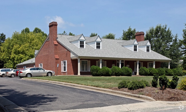
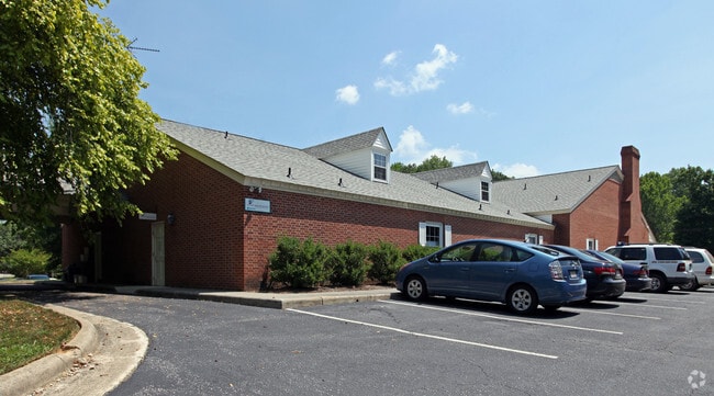
Property Record
210 S Cameron St, Hillsborough, NC 27278

NEARBY LISTINGS FOR SALE OR LEASE
-
-
View all Hillsborough listings for sale on LoopNet.com
Property Detail
210 S Cameron St
9874152266
W/S CAMERON ST
Officebuilding
Orange
AE
North Carolina
3710987400K
1.50 AC
2025
Orange County
2025
Raleigh/Durham
011002
Durham-Chapel Hill, NC
7,056 SF
DEMOGRAPHICS near 210 S Cameron St
1 Mile
3 Mile
5 Mile
2024 Total Population
2,882
19,535
26,433
2029 Population
2,697
18,128
24,506
Pop Growth 2024-2029
(6.42%)
(7.20%)
(7.29%)
Average Age
44
41
42
2024 Total Households
1,220
7,747
10,431
HH Growth 2024-2029
(6.72%)
(7.47%)
(7.55%)
Median Household Inc
$106,384
$86,685
$87,138
Avg Household Size
2.30
2.40
2.40
2024 Avg HH Vehicles
2.00
2.00
2.00
Median Home Value
$374,868
$316,681
$309,566
Median Year Built
1973
1988
1988
Nearby Places
Map Layers
Map Styles
 Street
 Aerial
- Restaurants
- Banks
- Shops
- Fitness
- Groceries
PUBLIC TRANSPORTATION
AIRPORT
Raleigh-Durham International
DRIVE
WALK
Distance
Raleigh-Durham International
40 min
27.8 mi
Nearby Properties
Address
Land Use
TOTAL SIZE
Lot Size
Zoning
Address
Land Use
TOTAL SIZE
Lot Size
Zoning
113,000 SF
57.70 AC
Address
Land Use
TOTAL SIZE
Lot Size
Zoning
189,774 SF
69.58 AC
Address
Land Use
TOTAL SIZE
Lot Size
Zoning
22,620 SF
21.26 AC
Address
Land Use
TOTAL SIZE
Lot Size
Zoning
27,606 SF
24.07 AC
Address
Land Use
TOTAL SIZE
Lot Size
Zoning
8,080 SF
21.81 AC
HI
Address
Land Use
TOTAL SIZE
Lot Size
Zoning
39,139 SF
34.34 AC
Address
Land Use
TOTAL SIZE
Lot Size
Zoning
32,868 SF
15.84 AC
HI
Address
Land Use
TOTAL SIZE
Lot Size
Zoning
182,655 SF
22.42 AC
HI
Address
Land Use
TOTAL SIZE
Lot Size
Zoning
61,329 SF
9.85 AC
Address
Land Use
TOTAL SIZE
Lot Size
Zoning
40,223 SF
20 AC
HI
Address
Land Use
TOTAL SIZE
Lot Size
Zoning
Address
Land Use
TOTAL SIZE
Lot Size
Zoning
12,150 SF
36.17 AC
HI
Address
Land Use
TOTAL SIZE
Lot Size
Zoning
2,745 SF
52.71 AC
Address
Land Use
TOTAL SIZE
Lot Size
Zoning
58,370 SF
7.04 AC
Address
Land Use
TOTAL SIZE
Lot Size
Zoning
144,303 SF
17.41 AC
Address
Land Use
TOTAL SIZE
Lot Size
Zoning
82,008 SF
16.20 AC
HIR1
Address
Land Use
TOTAL SIZE
Lot Size
Zoning
88,288 SF
18.13 AC
AR
Address
Land Use
TOTAL SIZE
Lot Size
Zoning
56,146 SF
11.92 AC
Address
Land Use
TOTAL SIZE
Lot Size
Zoning
74,820 SF
20 AC
R1
Address
Land Use
TOTAL SIZE
Lot Size
Zoning
43,401 SF
10.02 AC
HI
Address
Land Use
TOTAL SIZE
Lot Size
Zoning
40,236 SF
1.05 AC
HI
Address
Land Use
TOTAL SIZE
Lot Size
Zoning
56,100 SF
11.93 AC
Address
Land Use
TOTAL SIZE
Lot Size
Zoning
34,175 SF
33.02 AC
Address
Land Use
TOTAL SIZE
Lot Size
Zoning
39,200 SF
17.68 AC
HI
Address
Land Use
TOTAL SIZE
Lot Size
Zoning
104,769 SF
12.92 AC
HIR1
Address
Land Use
TOTAL SIZE
Lot Size
Zoning
66,920 SF
5.69 AC
Address
Land Use
TOTAL SIZE
Lot Size
Zoning
38,810 SF
11.25 AC
Address
Land Use
TOTAL SIZE
Lot Size
Zoning
86,400 SF
10.15 AC
HI
Address
Land Use
TOTAL SIZE
Lot Size
Zoning
24,828 SF
2.91 AC
The World's #1 Commercial Real Estate Marketplace
Connect with us
© 2026 CoStar Group
The information above has been obtained from sources believed reliable. While we do not doubt its accuracy we have not verified it and make no guarantee, warranty or representation about it. It is your responsibility to independently confirm its accuracy and completeness. Any projections, opinions, assumptions, or estimates used are for example only and do not represent the current or future performance of the property. The value of this transaction to you depends on tax and other factors which should be evaluated by your tax, financial, and legal advisors. You and your advisors should conduct a careful, independent investigation of the property to determine to your satisfaction the suitability of the property for your needs.