Property Record
210 S Catalpa St, Garnett, KS 66032
NEARBY LISTINGS FOR SALE OR LEASE
-
-
View all Garnett listings for sale on LoopNet.com
Property Detail
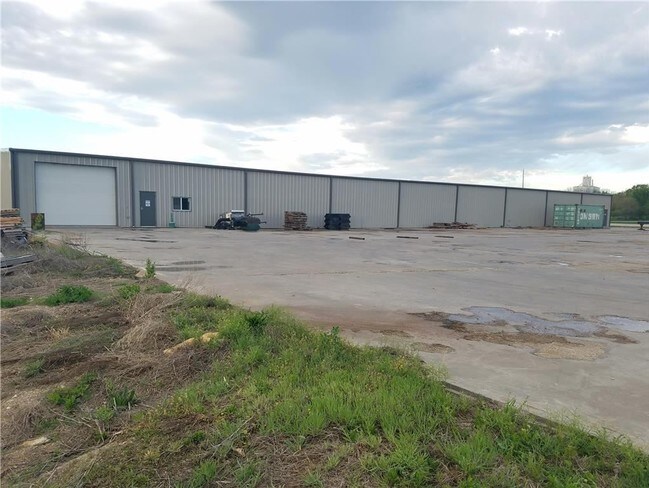
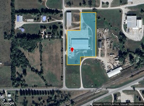
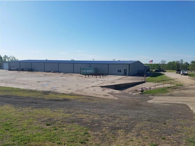
210 S Catalpa St
099-29-0-10-03-002.01-0
Maggio Add
Warehouse
MAGGIO ADD TO GARNETT, S29, T20, R20, BLOCK 1, ACRES 4.4, LT 10 & N100' LT 14, EX BEG NW COR LT10, E172.9', S233',
X
Anderson
20003C0211D
Kansas
0
10,14
2025
4.40 AC
953600
Kansas Area
3,072 SF
Other Market Areas
DEMOGRAPHICS near 210 S Catalpa St
1 Mile
3 Mile
5 Mile
2024 Total Population
1,191
3,729
4,124
2029 Population
1,197
3,728
4,118
Pop Growth 2024-2029
+ 0.50%
(0.03%)
(0.15%)
Average Age
42
41
41
2024 Total Households
511
1,549
1,701
HH Growth 2024-2029
+ 0.59%
0.00%
(0.18%)
Median Household Inc
$26,127
$39,999
$42,950
Avg Household Size
2.30
2.30
2.40
2024 Avg HH Vehicles
2.00
2.00
2.00
Median Home Value
$95,987
$98,288
$104,079
Median Year Built
1958
1957
1957
Nearby Places
Map Layers
Map Styles
 Street
 Aerial
- Restaurants
- Banks
- Shops
- Fitness
- Groceries
SALE & LEASE HISTORY
LISTING DATE
SALE/LEASE

Jun 03, 2019
For Sale
Nearby Properties
Address
Land Use
TOTAL SIZE
Lot Size
Zoning
Address
Land Use
TOTAL SIZE
Lot Size
Zoning
71,112 SF
10.01 AC
Address
Land Use
TOTAL SIZE
Lot Size
Zoning
107,506 SF
39.80 AC
Address
Land Use
TOTAL SIZE
Lot Size
Zoning
20,088 SF
3.26 AC
Address
Land Use
TOTAL SIZE
Lot Size
Zoning
31,855 SF
10.80 AC
Address
Land Use
TOTAL SIZE
Lot Size
Zoning
5,168 SF
38.30 AC
Address
Land Use
TOTAL SIZE
Lot Size
Zoning
10,415 SF
5.09 AC
Address
Land Use
TOTAL SIZE
Lot Size
Zoning
12,698 SF
0.55 AC
Address
Land Use
TOTAL SIZE
Lot Size
Zoning
7,728 SF
4.52 AC
Address
Land Use
TOTAL SIZE
Lot Size
Zoning
31,528 SF
0.39 AC
Address
Land Use
TOTAL SIZE
Lot Size
Zoning
18,004 SF
2.38 AC
Address
Land Use
TOTAL SIZE
Lot Size
Zoning
28,944 SF
3.70 AC
Address
Land Use
TOTAL SIZE
Lot Size
Zoning
17,390 SF
37.50 AC
Address
Land Use
TOTAL SIZE
Lot Size
Zoning
11,020 SF
8.90 AC
Address
Land Use
TOTAL SIZE
Lot Size
Zoning
11,772 SF
4.82 AC
Address
Land Use
TOTAL SIZE
Lot Size
Zoning
10,228 SF
0.50 AC
Address
Land Use
TOTAL SIZE
Lot Size
Zoning
19,157 SF
3.30 AC
Address
Land Use
TOTAL SIZE
Lot Size
Zoning
12,528 SF
2 AC
Address
Land Use
TOTAL SIZE
Lot Size
Zoning
10,400 SF
1.76 AC
Address
Land Use
TOTAL SIZE
Lot Size
Zoning
9,512 SF
2.10 AC
Address
Land Use
TOTAL SIZE
Lot Size
Zoning
13,280 SF
12.40 AC
Address
Land Use
TOTAL SIZE
Lot Size
Zoning
23,048 SF
3.30 AC
Address
Land Use
TOTAL SIZE
Lot Size
Zoning
7,436 SF
0.39 AC
Address
Land Use
TOTAL SIZE
Lot Size
Zoning
6,731 SF
0.18 AC
Address
Land Use
TOTAL SIZE
Lot Size
Zoning
529 SF
89.30 AC
Address
Land Use
TOTAL SIZE
Lot Size
Zoning
5,784 SF
0.89 AC
Address
Land Use
TOTAL SIZE
Lot Size
Zoning
6,300 SF
0.23 AC
Address
Land Use
TOTAL SIZE
Lot Size
Zoning
3,700 SF
57.93 AC
Address
Land Use
TOTAL SIZE
Lot Size
Zoning
2,000 SF
28.60 AC
Address
Land Use
TOTAL SIZE
Lot Size
Zoning
5,955 SF
2.79 AC
Address
Land Use
TOTAL SIZE
Lot Size
Zoning
5,832 SF
0.51 AC
The World's #1 Commercial Real Estate Marketplace
Connect with us
© 2025 CoStar Group
The information above has been obtained from sources believed reliable. While we do not doubt its accuracy we have not verified it and make no guarantee, warranty or representation about it. It is your responsibility to independently confirm its accuracy and completeness. Any projections, opinions, assumptions, or estimates used are for example only and do not represent the current or future performance of the property. The value of this transaction to you depends on tax and other factors which should be evaluated by your tax, financial, and legal advisors. You and your advisors should conduct a careful, independent investigation of the property to determine to your satisfaction the suitability of the property for your needs.