No Photo
Property Record
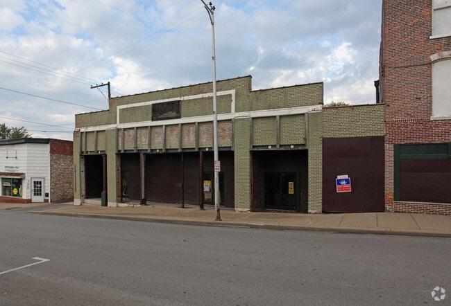
210 S Independence St, Harrisonville, MO 64701


Save to a Folder
{{folder.Name}}
{{folder.ListingIds.length}} Properties
{{folder.ListingIds.length}} Property
Create a New Folder
This Property Is For Sale
Property Detail
210 S Independence St
13-21-41-301-000-014.000
ORIG TOWN S695 BLK 7 EX W18
Nightclub
Cass
B and X Area of moderate flood hazard, usually the area between the limits of the 100-year and 500-year floods.
Missouri
2024
0.23 AC
2025
Cass County
060904
Kansas City
22,570 SF
Kansas City, MO-KS
NEARBY LISTINGS FOR SALE OR LEASE
DEMOGRAPHICS near 210 S Independence St
1 mile
3 mile
5 mile
2025 Total Population
6,289
11,947
14,260
2030 Population
6,515
12,397
14,799
Pop Growth 2025-2030
+ 3.59%
+ 3.77%
+ 3.78%
Average Age
39
41
41
2025 Total Households
2,454
4,637
5,515
HH Growth 2025-2030
+ 3.75%
+ 3.99%
+ 4.01%
Median Household Inc
$65,163
$73,055
$77,383
Avg Household Size
2.40
2.40
2.50
2025 Avg HH Vehicles
2.00
2.00
2.00
Median Home Value
$194,150
$251,214
$269,578
Median Year Built
1970
1977
1978
Nearby Places
Map Layers
Map Styles
 Street
 Aerial
Layers
 Traffic
 Biking
Places
Listings with unknown addresses are not visible on the map
- Restaurants
- Banks
- Shops
- Fitness
- Groceries
Nearby Properties
Address
Land Use
TOTAL SIZE
Lot Size
Zoning
Address
Land Use
TOTAL SIZE
Lot Size
Zoning
197,883 SF
30 AC
Address
Land Use
TOTAL SIZE
Lot Size
Zoning
367,575 SF
53.34 AC
Address
Land Use
TOTAL SIZE
Lot Size
Zoning
996,962 SF
75.28 AC
Address
Land Use
TOTAL SIZE
Lot Size
Zoning
219,735 SF
33.54 AC
Address
Land Use
TOTAL SIZE
Lot Size
Zoning
1,030,621 SF
43.38 AC
Address
Land Use
TOTAL SIZE
Lot Size
Zoning
411,232 SF
26.77 AC
Address
Land Use
TOTAL SIZE
Lot Size
Zoning
157,628 SF
5.06 AC
Address
Land Use
TOTAL SIZE
Lot Size
Zoning
55,413 SF
8 AC
Address
Land Use
TOTAL SIZE
Lot Size
Zoning
1,126,810 SF
17.17 AC
Address
Land Use
TOTAL SIZE
Lot Size
Zoning
42,378 SF
14.20 AC
Address
Land Use
TOTAL SIZE
Lot Size
Zoning
Address
Land Use
TOTAL SIZE
Lot Size
Zoning
15,840 SF
20 AC
Address
Land Use
TOTAL SIZE
Lot Size
Zoning
105,500 SF
4.29 AC
Address
Land Use
TOTAL SIZE
Lot Size
Zoning
103,920 SF
12.29 AC
Address
Land Use
TOTAL SIZE
Lot Size
Zoning
53,673 SF
12.16 AC
Address
Land Use
TOTAL SIZE
Lot Size
Zoning
65,356 SF
6.21 AC
Address
Land Use
TOTAL SIZE
Lot Size
Zoning
19,600 SF
6.30 AC
Address
Land Use
TOTAL SIZE
Lot Size
Zoning
40,784 SF
0.45 AC
Address
Land Use
TOTAL SIZE
Lot Size
Zoning
16,060 SF
6.49 AC
Address
Land Use
TOTAL SIZE
Lot Size
Zoning
460,328 SF
20 AC
Address
Land Use
TOTAL SIZE
Lot Size
Zoning
45,480 SF
6.46 AC
Address
Land Use
TOTAL SIZE
Lot Size
Zoning
62,008 SF
4.97 AC
Address
Land Use
TOTAL SIZE
Lot Size
Zoning
74,086 SF
5.39 AC
Address
Land Use
TOTAL SIZE
Lot Size
Zoning
88,957 SF
9.93 AC
Address
Land Use
TOTAL SIZE
Lot Size
Zoning
21,310 SF
3.40 AC
Address
Land Use
TOTAL SIZE
Lot Size
Zoning
20,600 SF
3.90 AC
Address
Land Use
TOTAL SIZE
Lot Size
Zoning
55,428 SF
10 AC
Address
Land Use
TOTAL SIZE
Lot Size
Zoning
48.57 AC
Address
Land Use
TOTAL SIZE
Lot Size
Zoning
107,500 SF
7.10 AC
Address
Land Use
TOTAL SIZE
Lot Size
Zoning
11,070 SF
10.15 AC
The World's #1 Commercial Real Estate Marketplace
Connect with us
© 2026 CoStar Group
The information above has been obtained from sources believed reliable. While we do not doubt its accuracy we have not verified it and make no guarantee, warranty or representation about it. It is your responsibility to independently confirm its accuracy and completeness. Any projections, opinions, assumptions, or estimates used are for example only and do not represent the current or future performance of the property. The value of this transaction to you depends on tax and other factors which should be evaluated by your tax, financial, and legal advisors. You and your advisors should conduct a careful, independent investigation of the property to determine to your satisfaction the suitability of the property for your needs.