Property Record
210 Saratoga Rd, Schenectady, NY 12302
NEARBY LISTINGS FOR SALE OR LEASE
Property Detail
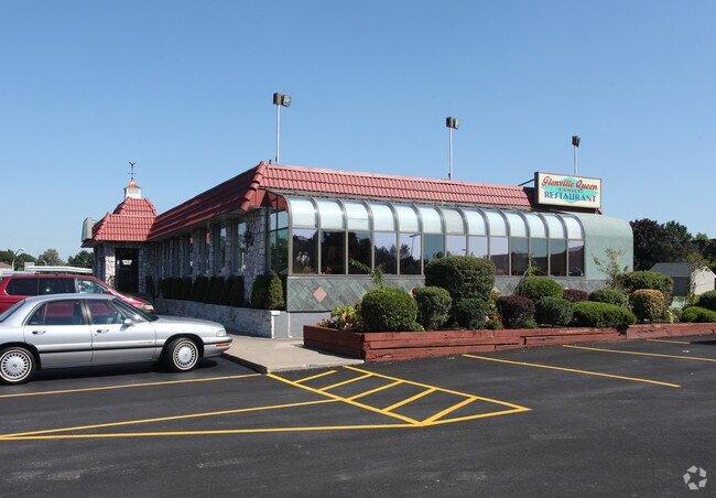
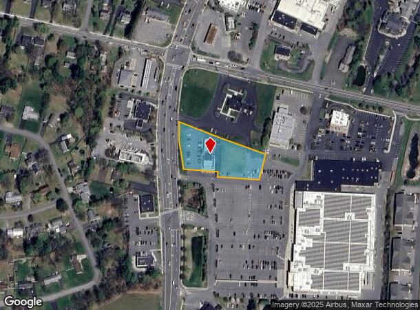
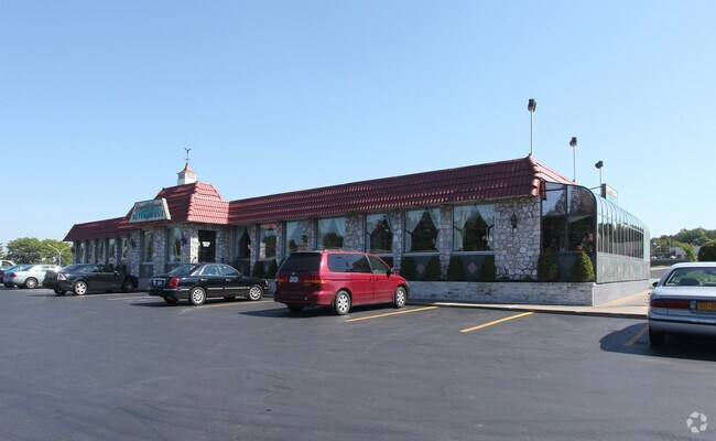
210 Saratoga Rd
022-011-0004-016-001-0000
Schenectady
Restaurantbuilding
New York
X
16.001
36093C0156D
1.16 AC
2025
Outer Schenectady County
2024
Albany/Schenectady/Troy
032402
Albany-Schenectady-Troy, NY
5,040 SF
DEMOGRAPHICS near 210 Saratoga Rd
1 Mile
3 Mile
5 Mile
2024 Total Population
5,660
29,759
95,896
2029 Population
5,984
31,332
100,934
Pop Growth 2024-2029
+ 5.72%
+ 5.29%
+ 5.25%
Average Age
44
43
40
2024 Total Households
2,305
12,087
39,148
HH Growth 2024-2029
+ 5.94%
+ 5.49%
+ 5.51%
Median Household Inc
$94,535
$88,416
$74,907
Avg Household Size
2.40
2.30
2.30
2024 Avg HH Vehicles
2.00
2.00
2.00
Median Home Value
$246,534
$231,829
$213,153
Median Year Built
1967
1965
1953
Nearby Places
Map Layers
Map Styles
 Street
 Aerial
- Restaurants
- Banks
- Shops
- Fitness
- Groceries
PUBLIC TRANSPORTATION
COMMUTER RAIL
Schenectady (Adirondack - VIA Rail, Empire Service - VIA Rail, Ethan Allen Express - VIA Rail, Lake Shore Limited - VIA Rail, Maple Leaf - VIA Rail, Toronto - New York - VIA Rail)
DRIVE
WALK
Distance
Schenectady (Adirondack - VIA Rail, Empire Service - VIA Rail, Ethan Allen Express - VIA Rail, Lake Shore Limited - VIA Rail, Maple Leaf - VIA Rail, Toronto - New York - VIA Rail)
9 min
4.4 mi
AIRPORT
Albany International
DRIVE
WALK
Distance
Albany International
27 min
13.7 mi
Freight Ports
Albany, NY Port
DRIVE
WALK
Distance
Albany, NY Port
38 min
23.9 mi
Nearby Properties
Address
Land Use
TOTAL SIZE
Lot Size
Zoning
Address
Land Use
TOTAL SIZE
Lot Size
Zoning
600 SF
28.40 AC
06 - INDUS
Address
Land Use
TOTAL SIZE
Lot Size
Zoning
306,803 SF
3.20 AC
Address
Land Use
TOTAL SIZE
Lot Size
Zoning
32,385 SF
5.02 AC
Address
Land Use
TOTAL SIZE
Lot Size
Zoning
19,080 SF
602.20 AC
CON
Address
Land Use
TOTAL SIZE
Lot Size
Zoning
12,528 SF
20.66 AC
R2
Address
Land Use
TOTAL SIZE
Lot Size
Zoning
184,376 SF
1.66 AC
03 - MULTI
Address
Land Use
TOTAL SIZE
Lot Size
Zoning
60,274 SF
12.95 AC
OT
Address
Land Use
TOTAL SIZE
Lot Size
Zoning
23,923 SF
109.83 AC
CON
Address
Land Use
TOTAL SIZE
Lot Size
Zoning
11,424 SF
42.41 AC
CON
Address
Land Use
TOTAL SIZE
Lot Size
Zoning
194.77 AC
Address
Land Use
TOTAL SIZE
Lot Size
Zoning
32,626 SF
81.39 AC
IR
Address
Land Use
TOTAL SIZE
Lot Size
Zoning
34,807 SF
15.91 AC
R2
Address
Land Use
TOTAL SIZE
Lot Size
Zoning
35,800 SF
8.80 AC
PD
Address
Land Use
TOTAL SIZE
Lot Size
Zoning
204,167 SF
33.90 AC
CON
Address
Land Use
TOTAL SIZE
Lot Size
Zoning
70,487 SF
2.51 AC
Address
Land Use
TOTAL SIZE
Lot Size
Zoning
135,000 SF
10.29 AC
CON
Address
Land Use
TOTAL SIZE
Lot Size
Zoning
12,572 SF
16.50 AC
CON
Address
Land Use
TOTAL SIZE
Lot Size
Zoning
16,392 SF
14.64 AC
CON
Address
Land Use
TOTAL SIZE
Lot Size
Zoning
140,900 SF
9.47 AC
Address
Land Use
TOTAL SIZE
Lot Size
Zoning
1,833 SF
184 AC
CON
Address
Land Use
TOTAL SIZE
Lot Size
Zoning
157,101 SF
19.60 AC
CON
Address
Land Use
TOTAL SIZE
Lot Size
Zoning
60,000 SF
3.48 AC
CON
Address
Land Use
TOTAL SIZE
Lot Size
Zoning
85,953 SF
2.24 AC
CON
Address
Land Use
TOTAL SIZE
Lot Size
Zoning
4.21 AC
02 - SINGL
Address
Land Use
TOTAL SIZE
Lot Size
Zoning
123,226 SF
31.66 AC
CON
Address
Land Use
TOTAL SIZE
Lot Size
Zoning
81,125 SF
8.60 AC
CON
Address
Land Use
TOTAL SIZE
Lot Size
Zoning
8,736 SF
10.40 AC
R3
Address
Land Use
TOTAL SIZE
Lot Size
Zoning
61,501 SF
14.91 AC
Address
Land Use
TOTAL SIZE
Lot Size
Zoning
62,760 SF
2.41 AC
Address
Land Use
TOTAL SIZE
Lot Size
Zoning
47,600 SF
6.71 AC
CON
The World's #1 Commercial Real Estate Marketplace
Connect with us
© 2025 CoStar Group
The information above has been obtained from sources believed reliable. While we do not doubt its accuracy we have not verified it and make no guarantee, warranty or representation about it. It is your responsibility to independently confirm its accuracy and completeness. Any projections, opinions, assumptions, or estimates used are for example only and do not represent the current or future performance of the property. The value of this transaction to you depends on tax and other factors which should be evaluated by your tax, financial, and legal advisors. You and your advisors should conduct a careful, independent investigation of the property to determine to your satisfaction the suitability of the property for your needs.