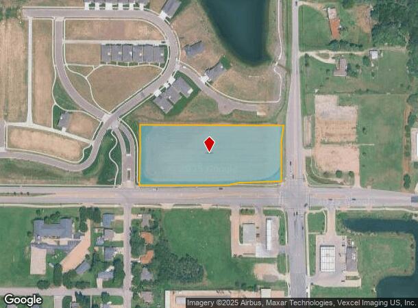
Property Record
210 W 21St St, Andover, KS 67002
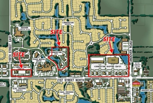
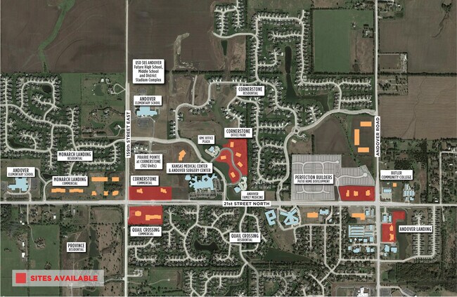
NEARBY LISTINGS FOR SALE OR LEASE
Property Detail
210 W 21St St
303-06-0-40-09-005-00-0
S06, T27, R03E, ACRES 3.9, S335 E806.13 SE1/4 EXC W89 LESS ROW
Rangelandgrazing
Butler
AE
Kansas
20173C0382G
3.90 AC
2024
Outlying Butler County
2025
Wichita
020208
Wichita, KS
DEMOGRAPHICS near 210 W 21St St
1 Mile
3 Mile
5 Mile
2024 Total Population
4,530
20,347
43,548
2029 Population
4,714
20,818
44,533
Pop Growth 2024-2029
+ 4.06%
+ 2.31%
+ 2.26%
Average Age
34
38
39
2024 Total Households
1,408
6,800
15,387
HH Growth 2024-2029
+ 4.12%
+ 2.28%
+ 2.22%
Median Household Inc
$107,596
$117,319
$110,510
Avg Household Size
3.10
2.90
2.80
2024 Avg HH Vehicles
2.00
2.00
2.00
Median Home Value
$250,149
$293,602
$292,869
Median Year Built
2005
2001
2000
Nearby Places
Map Layers
Map Styles
 Street
 Aerial
- Restaurants
- Banks
- Shops
- Fitness
- Groceries
PUBLIC TRANSPORTATION
AIRPORT
Wichita Dwight D Eisenhower Ntl
DRIVE
WALK
Distance
Wichita Dwight D Eisenhower Ntl
30 min
21.2 mi
Freight Ports
Tulsa Port Of Catoosa
DRIVE
WALK
Distance
Tulsa Port Of Catoosa
214 min
202.4 mi
SALE & LEASE HISTORY
LISTING DATE
SALE/LEASE

Jun 14, 2019
For Lease
Jun 14, 2019
For Sale
Nearby Properties
Address
Land Use
TOTAL SIZE
Lot Size
Zoning
Address
Land Use
TOTAL SIZE
Lot Size
Zoning
121.30 AC
Address
Land Use
TOTAL SIZE
Lot Size
Zoning
126.70 AC
Address
Land Use
TOTAL SIZE
Lot Size
Zoning
32.40 AC
Address
Land Use
TOTAL SIZE
Lot Size
Zoning
123,253 SF
14.60 AC
Address
Land Use
TOTAL SIZE
Lot Size
Zoning
71,058 SF
17.47 AC
SF-5
Address
Land Use
TOTAL SIZE
Lot Size
Zoning
19.70 AC
Address
Land Use
TOTAL SIZE
Lot Size
Zoning
15,597 SF
67.40 AC
Address
Land Use
TOTAL SIZE
Lot Size
Zoning
37,934 SF
24.82 AC
SF-5
Address
Land Use
TOTAL SIZE
Lot Size
Zoning
20.60 AC
Address
Land Use
TOTAL SIZE
Lot Size
Zoning
24.20 AC
Address
Land Use
TOTAL SIZE
Lot Size
Zoning
47,234 SF
8.70 AC
Address
Land Use
TOTAL SIZE
Lot Size
Zoning
14,582 SF
5.30 AC
Address
Land Use
TOTAL SIZE
Lot Size
Zoning
20,113 SF
2.90 AC
Address
Land Use
TOTAL SIZE
Lot Size
Zoning
32,561 SF
18.04 AC
SF-5
Address
Land Use
TOTAL SIZE
Lot Size
Zoning
70,937 SF
9.60 AC
Address
Land Use
TOTAL SIZE
Lot Size
Zoning
83,625 SF
11 AC
Address
Land Use
TOTAL SIZE
Lot Size
Zoning
129,575 SF
10.29 AC
LC
Address
Land Use
TOTAL SIZE
Lot Size
Zoning
20,744 SF
2.50 AC
Address
Land Use
TOTAL SIZE
Lot Size
Zoning
174,164 SF
18.50 AC
Address
Land Use
TOTAL SIZE
Lot Size
Zoning
3.50 AC
Address
Land Use
TOTAL SIZE
Lot Size
Zoning
10,201 SF
2 AC
Address
Land Use
TOTAL SIZE
Lot Size
Zoning
17,048 SF
7.77 AC
SF-5
Address
Land Use
TOTAL SIZE
Lot Size
Zoning
9,839 SF
2.60 AC
Address
Land Use
TOTAL SIZE
Lot Size
Zoning
9.60 AC
Address
Land Use
TOTAL SIZE
Lot Size
Zoning
3,004 SF
2.60 AC
Address
Land Use
TOTAL SIZE
Lot Size
Zoning
Address
Land Use
TOTAL SIZE
Lot Size
Zoning
12,424 SF
1.70 AC
B2
Address
Land Use
TOTAL SIZE
Lot Size
Zoning
16,284 SF
1.60 AC
Address
Land Use
TOTAL SIZE
Lot Size
Zoning
55,136 SF
4.70 AC
LC
Address
Land Use
TOTAL SIZE
Lot Size
Zoning
3.20 AC
The World's #1 Commercial Real Estate Marketplace
Connect with us
© 2025 CoStar Group
The information above has been obtained from sources believed reliable. While we do not doubt its accuracy we have not verified it and make no guarantee, warranty or representation about it. It is your responsibility to independently confirm its accuracy and completeness. Any projections, opinions, assumptions, or estimates used are for example only and do not represent the current or future performance of the property. The value of this transaction to you depends on tax and other factors which should be evaluated by your tax, financial, and legal advisors. You and your advisors should conduct a careful, independent investigation of the property to determine to your satisfaction the suitability of the property for your needs.