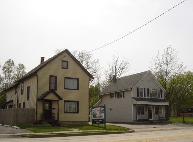
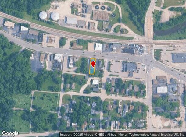
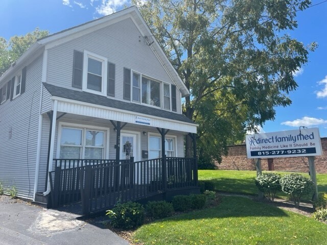
Property Record
210 W Maple St, New Lenox, IL 60451

NEARBY LISTINGS FOR SALE OR LEASE
Property Detail
210 W Maple St
Chicago-Naperville-Elgin, IL-IN-WI
The Village Of Tracy
15-08-16-414-004
LOT 2 LOT 2 (EX THE W 35 FT THROF) IN BLK 5, IN THE VILLAGE OF TRACY, (NOW NEW LENOX), BEING A SUB OF PRT OF THE E1/2 OF THE
Commercialnec
Will
X
Illinois
17197C0190G
2
2024
0.13 AC
2024
Joliet/Central Will
881111
Chicago
DEMOGRAPHICS near 210 W Maple St
1 Mile
3 Mile
5 Mile
2024 Total Population
7,437
35,537
91,791
2029 Population
7,461
35,501
91,888
Pop Growth 2024-2029
+ 0.32%
(0.10%)
+ 0.11%
Average Age
41
40
39
2024 Total Households
2,765
12,319
31,170
HH Growth 2024-2029
+ 0.33%
(0.14%)
+ 0.04%
Median Household Inc
$101,569
$113,811
$105,587
Avg Household Size
2.60
2.80
2.90
2024 Avg HH Vehicles
2.00
2.00
2.00
Median Home Value
$307,280
$328,377
$326,804
Median Year Built
1982
1991
1991
Nearby Places
Map Layers
Map Styles
 Street
 Aerial
- Restaurants
- Banks
- Shops
- Fitness
- Groceries
PUBLIC TRANSPORTATION
COMMUTER RAIL
New Lenox Station (Rock Island District Line - Northeast Illinois Regional Commuter Railroad (Metra))
DRIVE
WALK
Distance
New Lenox Station (Rock Island District Line - Northeast Illinois Regional Commuter Railroad (Metra))
1 min
4 min
0.2 mi
New Lenox Laraway Road (SouthWest Service - Northeast Illinois Regional Commuter Railroad (Metra))
DRIVE
WALK
Distance
New Lenox Laraway Road (SouthWest Service - Northeast Illinois Regional Commuter Railroad (Metra))
7 min
3.0 mi
AIRPORT
Chicago Midway International
DRIVE
WALK
Distance
Chicago Midway International
43 min
31.0 mi
Freight Ports
Port Milwaukee
DRIVE
WALK
Distance
Port Milwaukee
141 min
114.1 mi
SALE & LEASE HISTORY
LISTING DATE
SALE/LEASE

Sep 13, 2022
For Lease
Nearby Properties
Address
Land Use
TOTAL SIZE
Lot Size
Zoning
Address
Land Use
TOTAL SIZE
Lot Size
Zoning
27.63 AC
Address
Land Use
TOTAL SIZE
Lot Size
Zoning
53.05 AC
Address
Land Use
TOTAL SIZE
Lot Size
Zoning
45.09 AC
Address
Land Use
TOTAL SIZE
Lot Size
Zoning
52.25 AC
Address
Land Use
TOTAL SIZE
Lot Size
Zoning
26.04 AC
Address
Land Use
TOTAL SIZE
Lot Size
Zoning
Address
Land Use
TOTAL SIZE
Lot Size
Zoning
35.69 AC
Address
Land Use
TOTAL SIZE
Lot Size
Zoning
17.49 AC
Address
Land Use
TOTAL SIZE
Lot Size
Zoning
30.99 AC
Address
Land Use
TOTAL SIZE
Lot Size
Zoning
22.77 AC
Address
Land Use
TOTAL SIZE
Lot Size
Zoning
20.66 AC
Address
Land Use
TOTAL SIZE
Lot Size
Zoning
31.12 AC
Address
Land Use
TOTAL SIZE
Lot Size
Zoning
4.48 AC
Address
Land Use
TOTAL SIZE
Lot Size
Zoning
12.03 AC
Address
Land Use
TOTAL SIZE
Lot Size
Zoning
19.52 AC
Address
Land Use
TOTAL SIZE
Lot Size
Zoning
5.67 AC
Address
Land Use
TOTAL SIZE
Lot Size
Zoning
11.46 AC
Address
Land Use
TOTAL SIZE
Lot Size
Zoning
10.32 AC
Address
Land Use
TOTAL SIZE
Lot Size
Zoning
Address
Land Use
TOTAL SIZE
Lot Size
Zoning
13.14 AC
Address
Land Use
TOTAL SIZE
Lot Size
Zoning
10.28 AC
Address
Land Use
TOTAL SIZE
Lot Size
Zoning
Address
Land Use
TOTAL SIZE
Lot Size
Zoning
4.51 AC
Address
Land Use
TOTAL SIZE
Lot Size
Zoning
16.31 AC
Address
Land Use
TOTAL SIZE
Lot Size
Zoning
Address
Land Use
TOTAL SIZE
Lot Size
Zoning
11.57 AC
Address
Land Use
TOTAL SIZE
Lot Size
Zoning
8.79 AC
Address
Land Use
TOTAL SIZE
Lot Size
Zoning
6.76 AC
Address
Land Use
TOTAL SIZE
Lot Size
Zoning
Address
Land Use
TOTAL SIZE
Lot Size
Zoning
4.65 AC
The World's #1 Commercial Real Estate Marketplace
Connect with us
© 2025 CoStar Group
The information above has been obtained from sources believed reliable. While we do not doubt its accuracy we have not verified it and make no guarantee, warranty or representation about it. It is your responsibility to independently confirm its accuracy and completeness. Any projections, opinions, assumptions, or estimates used are for example only and do not represent the current or future performance of the property. The value of this transaction to you depends on tax and other factors which should be evaluated by your tax, financial, and legal advisors. You and your advisors should conduct a careful, independent investigation of the property to determine to your satisfaction the suitability of the property for your needs.