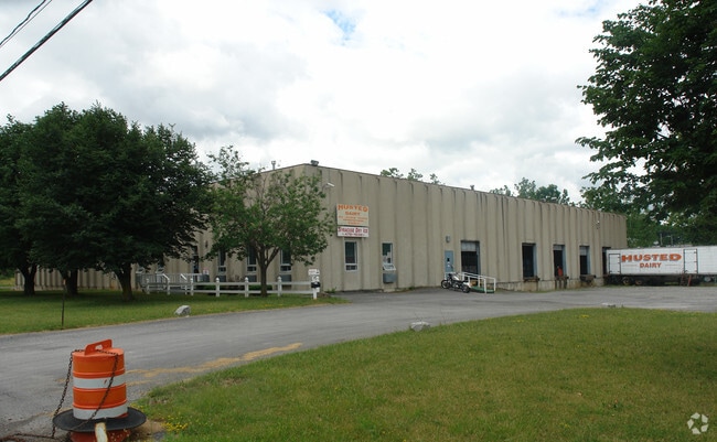
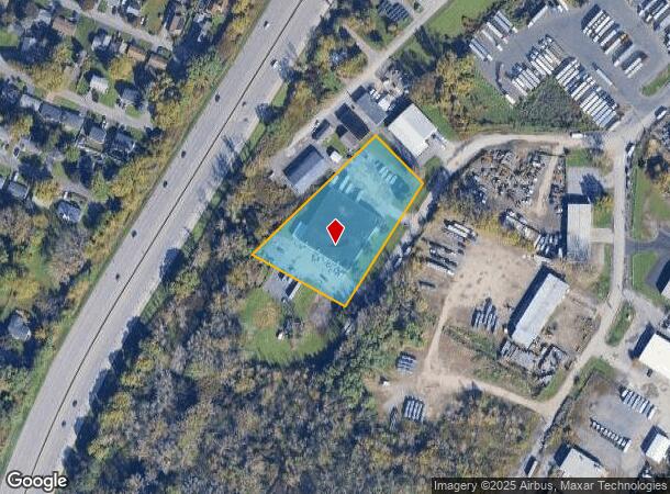
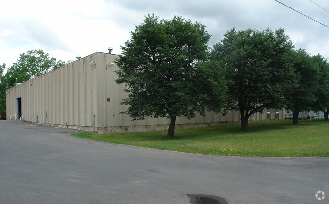
Property Record
210 W Terminal Rd, Liverpool, NY 13088
NEARBY LISTINGS FOR SALE OR LEASE
Property Detail
210 W Terminal Rd
314889-086-000-0002-010-000-0000
MARSH LTS 5 & 7
Warehouse
Onondaga
X
New York
36067C0208F
10.000
2025
2.09 AC
2024
NE Outer Onondaga County
014200
Syracuse
24,624 SF
Syracuse, NY
DEMOGRAPHICS near 210 W Terminal Rd
1 Mile
3 Mile
5 Mile
2024 Total Population
7,344
89,520
225,508
2029 Population
7,127
87,203
220,378
Pop Growth 2024-2029
(2.95%)
(2.59%)
(2.27%)
Average Age
42
39
39
2024 Total Households
3,085
40,144
95,325
HH Growth 2024-2029
(3.05%)
(2.56%)
(2.38%)
Median Household Inc
$60,567
$48,768
$53,201
Avg Household Size
2.20
2.10
2.20
2024 Avg HH Vehicles
1.00
1.00
1.00
Median Home Value
$118,583
$129,135
$142,528
Median Year Built
1954
1952
1954
Nearby Places
- Restaurants
- Banks
- Shops
- Fitness
- Groceries
PUBLIC TRANSPORTATION
COMMUTER RAIL
DRIVE
WALK
Distance
5 min
1.8 mi
DRIVE
WALK
Distance
6 min
1.8 mi
AIRPORT
Syracuse Hancock International
DRIVE
WALK
Distance
Syracuse Hancock International
9 min
4.2 mi
SALE & LEASE HISTORY
LISTING DATE
SALE/LEASE

Jul 10, 2017
For Lease
Nearby Properties
Address
Land Use
TOTAL SIZE
Lot Size
Zoning
Address
Land Use
TOTAL SIZE
Lot Size
Zoning
847,042 SF
42.78 AC
23
Address
Land Use
TOTAL SIZE
Lot Size
Zoning
57,011 SF
22.53 AC
22
Address
Land Use
TOTAL SIZE
Lot Size
Zoning
508,658 SF
2.23 AC
25
Address
Land Use
TOTAL SIZE
Lot Size
Zoning
848,000 SF
30.29 AC
Address
Land Use
TOTAL SIZE
Lot Size
Zoning
522,469 SF
1.87 AC
14
Address
Land Use
TOTAL SIZE
Lot Size
Zoning
6,598 SF
4.09 AC
14
Address
Land Use
TOTAL SIZE
Lot Size
Zoning
653,177 SF
1.94 AC
13
Address
Land Use
TOTAL SIZE
Lot Size
Zoning
224,736 SF
2.48 AC
10
Address
Land Use
TOTAL SIZE
Lot Size
Zoning
316,848 SF
10.72 AC
08 - GOVER
Address
Land Use
TOTAL SIZE
Lot Size
Zoning
13,800 SF
2.10 AC
16
Address
Land Use
TOTAL SIZE
Lot Size
Zoning
275,732 SF
2.91 AC
13
Address
Land Use
TOTAL SIZE
Lot Size
Zoning
296,703 SF
1.48 AC
25
Address
Land Use
TOTAL SIZE
Lot Size
Zoning
5,837 SF
1.26 AC
15
Address
Land Use
TOTAL SIZE
Lot Size
Zoning
169,752 SF
12.81 AC
04 - FARM
Address
Land Use
TOTAL SIZE
Lot Size
Zoning
432,246 SF
37.21 AC
05 - COMME
Address
Land Use
TOTAL SIZE
Lot Size
Zoning
367,508 SF
0.48 AC
12
Address
Land Use
TOTAL SIZE
Lot Size
Zoning
329,212 SF
2.11 AC
12
Address
Land Use
TOTAL SIZE
Lot Size
Zoning
79,344 SF
1.65 AC
14
Address
Land Use
TOTAL SIZE
Lot Size
Zoning
410,021 SF
2.22 AC
05 - COMME
Address
Land Use
TOTAL SIZE
Lot Size
Zoning
22.16 AC
06 - INDUS
Address
Land Use
TOTAL SIZE
Lot Size
Zoning
11,484 SF
16.36 AC
03 - MULTI
Address
Land Use
TOTAL SIZE
Lot Size
Zoning
297,376 SF
1.88 AC
13
Address
Land Use
TOTAL SIZE
Lot Size
Zoning
216,079 SF
17.57 AC
06 - INDUS
Address
Land Use
TOTAL SIZE
Lot Size
Zoning
285,000 SF
10.94 AC
23
Address
Land Use
TOTAL SIZE
Lot Size
Zoning
215,578 SF
0.30 AC
13
Address
Land Use
TOTAL SIZE
Lot Size
Zoning
77,150 SF
159.25 AC
06 - INDUS
Address
Land Use
TOTAL SIZE
Lot Size
Zoning
35,848 SF
1.68 AC
05 - COMME
Address
Land Use
TOTAL SIZE
Lot Size
Zoning
377,454 SF
5.27 AC
15
Address
Land Use
TOTAL SIZE
Lot Size
Zoning
55,542 SF
1.62 AC
22
Address
Land Use
TOTAL SIZE
Lot Size
Zoning
151,326 SF
9.23 AC
05 - COMME
The World's #1 Commercial Real Estate Marketplace
Connect with us
© 2025 CoStar Group
The information above has been obtained from sources believed reliable. While we do not doubt its accuracy we have not verified it and make no guarantee, warranty or representation about it. It is your responsibility to independently confirm its accuracy and completeness. Any projections, opinions, assumptions, or estimates used are for example only and do not represent the current or future performance of the property. The value of this transaction to you depends on tax and other factors which should be evaluated by your tax, financial, and legal advisors. You and your advisors should conduct a careful, independent investigation of the property to determine to your satisfaction the suitability of the property for your needs.