Property Record
210 Wellhouse Loop, Richland, WA 99352
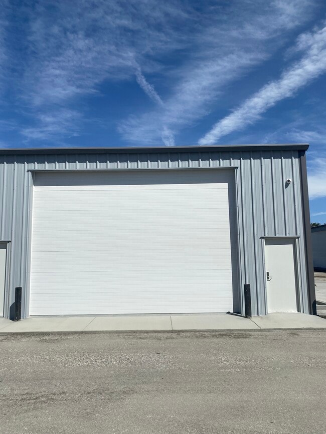


Property Detail
210 Wellhouse Loop
Kennewick-Richland, WA
PLAT OF RICHLAND BLOCK 400 LOT 11 PORTION DEFINED AS FOLLOWS: BEGINNING AT THE INTERSECTION OF WELLSIAN WAY AND ELLIOT STREET. SAID POINT BEING LOCATED ON THE CENTERLINE OF WELLSIAN WAY. THENCE SOUTH 00 DEGREES 5113 EAST ALONG CENTERLINE OF WELLSIAN
115981020400031
Benton
Commercialnec
Washington
2025
11
2025
1.03 AC
010600
Yakima/Kennewick
23,600 SF
Other Market Areas
NEARBY LISTINGS FOR SALE OR LEASE
-
-
View all Richland listings for sale on LoopNet.com
DEMOGRAPHICS near 210 Wellhouse Loop
1 mile
3 mile
5 mile
2025 Total Population
9,676
51,911
123,253
2030 Population
10,004
54,141
129,195
Pop Growth 2025-2030
+ 3.39%
+ 4.30%
+ 4.82%
Average Age
37
39
38
2025 Total Households
4,072
20,078
46,072
HH Growth 2025-2030
+ 3.36%
+ 4.27%
+ 4.73%
Median Household Inc
$67,549
$89,924
$97,118
Avg Household Size
2.30
2.50
2.60
2025 Avg HH Vehicles
2.00
2.00
2.00
Median Home Value
$332,598
$445,286
$451,361
Median Year Built
1962
1986
1998
Nearby Places
Map Layers
Map Styles
 Street
 Aerial
Layers
 Traffic
 Biking
Places
Listings with unknown addresses are not visible on the map
- Restaurants
- Banks
- Shops
- Fitness
- Groceries
PUBLIC TRANSPORTATION
AIRPORT
Tri-Cities
Drive
Walk
Distance
Tri-Cities
17 min
10.5 mi
SALE & LEASE HISTORY
LISTING DATE
SALE/LEASE

Aug 08, 2022
For Sale
Aug 04, 2022
For Lease
Nearby Properties
Address
Land Use
TOTAL SIZE
Lot Size
Zoning
Address
Land Use
TOTAL SIZE
Lot Size
Zoning
562,186 SF
7.61 AC
Address
Land Use
TOTAL SIZE
Lot Size
Zoning
340,554 SF
16.21 AC
RICHLAND -
Address
Land Use
TOTAL SIZE
Lot Size
Zoning
353,137 SF
60.86 AC
Address
Land Use
TOTAL SIZE
Lot Size
Zoning
236,556 SF
11.34 AC
Address
Land Use
TOTAL SIZE
Lot Size
Zoning
185,307 SF
9.13 AC
Address
Land Use
TOTAL SIZE
Lot Size
Zoning
183,204 SF
14.94 AC
Address
Land Use
TOTAL SIZE
Lot Size
Zoning
428,225 SF
12.60 AC
Address
Land Use
TOTAL SIZE
Lot Size
Zoning
143,749 SF
6.86 AC
RICHLAND -
Address
Land Use
TOTAL SIZE
Lot Size
Zoning
4,415 SF
22.32 AC
Address
Land Use
TOTAL SIZE
Lot Size
Zoning
116,318 SF
2.74 AC
Address
Land Use
TOTAL SIZE
Lot Size
Zoning
160,160 SF
16.25 AC
58
Address
Land Use
TOTAL SIZE
Lot Size
Zoning
109,517 SF
4.67 AC
Address
Land Use
TOTAL SIZE
Lot Size
Zoning
113,052 SF
3.32 AC
Address
Land Use
TOTAL SIZE
Lot Size
Zoning
176,669 SF
Address
Land Use
TOTAL SIZE
Lot Size
Zoning
220,970 SF
1.28 AC
Address
Land Use
TOTAL SIZE
Lot Size
Zoning
112 SF
14.15 AC
Address
Land Use
TOTAL SIZE
Lot Size
Zoning
126,266 SF
7 AC
Address
Land Use
TOTAL SIZE
Lot Size
Zoning
86,104 SF
3.26 AC
Address
Land Use
TOTAL SIZE
Lot Size
Zoning
74,028 SF
6.02 AC
Address
Land Use
TOTAL SIZE
Lot Size
Zoning
69,488 SF
1.69 AC
Address
Land Use
TOTAL SIZE
Lot Size
Zoning
160,156 SF
5.65 AC
Address
Land Use
TOTAL SIZE
Lot Size
Zoning
96,486 SF
13.24 AC
Address
Land Use
TOTAL SIZE
Lot Size
Zoning
67,708 SF
1.80 AC
Address
Land Use
TOTAL SIZE
Lot Size
Zoning
31,531 SF
5.07 AC
Address
Land Use
TOTAL SIZE
Lot Size
Zoning
127,195 SF
9.16 AC
Address
Land Use
TOTAL SIZE
Lot Size
Zoning
137,322 SF
10.63 AC
Address
Land Use
TOTAL SIZE
Lot Size
Zoning
76,249 SF
13 AC
Address
Land Use
TOTAL SIZE
Lot Size
Zoning
102,189 SF
12.57 AC
Address
Land Use
TOTAL SIZE
Lot Size
Zoning
74,089 SF
12.33 AC
Address
Land Use
TOTAL SIZE
Lot Size
Zoning
66,380 SF
2.98 AC
The World's #1 Commercial Real Estate Marketplace
Connect with us
© 2026 CoStar Group
The information above has been obtained from sources believed reliable. While we do not doubt its accuracy we have not verified it and make no guarantee, warranty or representation about it. It is your responsibility to independently confirm its accuracy and completeness. Any projections, opinions, assumptions, or estimates used are for example only and do not represent the current or future performance of the property. The value of this transaction to you depends on tax and other factors which should be evaluated by your tax, financial, and legal advisors. You and your advisors should conduct a careful, independent investigation of the property to determine to your satisfaction the suitability of the property for your needs.