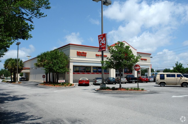
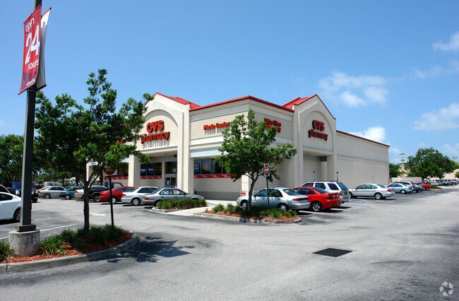
Property Record
2100 66Th St N, Saint Petersburg, FL 33710
NEARBY LISTINGS FOR SALE OR LEASE
Property Detail
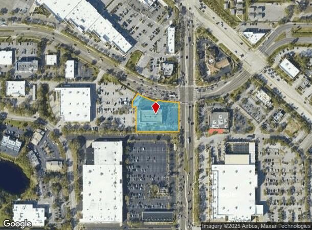
2100 66Th St N
Tampa-St. Petersburg-Clearwater, FL
Crosswinds Mall 1St Add
18-31-16-19746-001-0021
CROSSWINDS MALL 1ST ADD REP BLK 1, THAT PART OF LOT 2 DESC BEG SE COR OF SD LOT 2 TH S89D4930W 291FT TH N00D1030W 165.57FT TH S89D4930W 27.82FT TH N00D1030W 37FT TH N30D0729E 67.75FT TH CUR RAD 486.25FT ARC 144.50FT CB S68D2319E 143.97FT TH N13D0553E
Storebuilding
Pinellas
AE
Florida
12103C0211H
2
2024
1.48 AC
2025
South Pinellas
022501
Tampa/St Petersburg
13,403 SF
DEMOGRAPHICS near 2100 66Th St N
1 Mile
3 Mile
5 Mile
2024 Total Population
11,004
104,427
252,375
2029 Population
10,931
104,381
254,325
Pop Growth 2024-2029
(0.66%)
(0.04%)
+ 0.77%
Average Age
44
46
46
2024 Total Households
4,839
47,990
115,571
HH Growth 2024-2029
(0.95%)
(0.20%)
+ 0.80%
Median Household Inc
$64,035
$60,219
$59,554
Avg Household Size
2.20
2.10
2.10
2024 Avg HH Vehicles
2.00
2.00
2.00
Median Home Value
$278,717
$257,422
$262,251
Median Year Built
1962
1965
1968
Nearby Places
Map Layers
Map Styles
 Street
 Aerial
- Restaurants
- Banks
- Shops
- Fitness
- Groceries
PUBLIC TRANSPORTATION
AIRPORT
St Pete-Clearwater International
DRIVE
WALK
Distance
St Pete-Clearwater International
27 min
12.2 mi
Tampa International
DRIVE
WALK
Distance
Tampa International
36 min
22.5 mi
Sarasota/Bradenton International
DRIVE
WALK
Distance
Sarasota/Bradenton International
55 min
35.3 mi
Freight Ports
Port of Tampa Bay
DRIVE
WALK
Distance
Port of Tampa Bay
43 min
27.0 mi
Nearby Properties
Address
Land Use
TOTAL SIZE
Lot Size
Zoning
Address
Land Use
TOTAL SIZE
Lot Size
Zoning
738,882 SF
43.34 AC
Address
Land Use
TOTAL SIZE
Lot Size
Zoning
396,428 SF
19.76 AC
Address
Land Use
TOTAL SIZE
Lot Size
Zoning
436,119 SF
22.24 AC
Address
Land Use
TOTAL SIZE
Lot Size
Zoning
263,050 SF
34.20 AC
Address
Land Use
TOTAL SIZE
Lot Size
Zoning
142,529 SF
46.62 AC
Address
Land Use
TOTAL SIZE
Lot Size
Zoning
265,929 SF
5.43 AC
Address
Land Use
TOTAL SIZE
Lot Size
Zoning
186,094 SF
11.96 AC
Address
Land Use
TOTAL SIZE
Lot Size
Zoning
181,708 SF
14.92 AC
R3
Address
Land Use
TOTAL SIZE
Lot Size
Zoning
363,074 SF
36.90 AC
Address
Land Use
TOTAL SIZE
Lot Size
Zoning
127,237 SF
10.53 AC
Address
Land Use
TOTAL SIZE
Lot Size
Zoning
150,235 SF
17.90 AC
Address
Land Use
TOTAL SIZE
Lot Size
Zoning
195,863 SF
18.57 AC
Address
Land Use
TOTAL SIZE
Lot Size
Zoning
360,137 SF
37.64 AC
AE
Address
Land Use
TOTAL SIZE
Lot Size
Zoning
156,994 SF
29.11 AC
Address
Land Use
TOTAL SIZE
Lot Size
Zoning
142,281 SF
1.57 AC
Address
Land Use
TOTAL SIZE
Lot Size
Zoning
144,334 SF
2.50 AC
Address
Land Use
TOTAL SIZE
Lot Size
Zoning
248,572 SF
15.22 AC
PSP
Address
Land Use
TOTAL SIZE
Lot Size
Zoning
48,862 SF
3.72 AC
Address
Land Use
TOTAL SIZE
Lot Size
Zoning
220,805 SF
5.93 AC
Address
Land Use
TOTAL SIZE
Lot Size
Zoning
145,047 SF
12.03 AC
Address
Land Use
TOTAL SIZE
Lot Size
Zoning
151,391 SF
3.13 AC
Address
Land Use
TOTAL SIZE
Lot Size
Zoning
154,986 SF
11.08 AC
Address
Land Use
TOTAL SIZE
Lot Size
Zoning
46,749 SF
5.80 AC
Address
Land Use
TOTAL SIZE
Lot Size
Zoning
130,192 SF
2.40 AC
Address
Land Use
TOTAL SIZE
Lot Size
Zoning
49,898 SF
77.25 AC
Address
Land Use
TOTAL SIZE
Lot Size
Zoning
119,580 SF
4.18 AC
Address
Land Use
TOTAL SIZE
Lot Size
Zoning
221,615 SF
16.33 AC
Address
Land Use
TOTAL SIZE
Lot Size
Zoning
117,837 SF
11.92 AC
Address
Land Use
TOTAL SIZE
Lot Size
Zoning
99,045 SF
8.79 AC
Address
Land Use
TOTAL SIZE
Lot Size
Zoning
151,193 SF
23.54 AC
The World's #1 Commercial Real Estate Marketplace
Connect with us
© 2025 CoStar Group
The information above has been obtained from sources believed reliable. While we do not doubt its accuracy we have not verified it and make no guarantee, warranty or representation about it. It is your responsibility to independently confirm its accuracy and completeness. Any projections, opinions, assumptions, or estimates used are for example only and do not represent the current or future performance of the property. The value of this transaction to you depends on tax and other factors which should be evaluated by your tax, financial, and legal advisors. You and your advisors should conduct a careful, independent investigation of the property to determine to your satisfaction the suitability of the property for your needs.