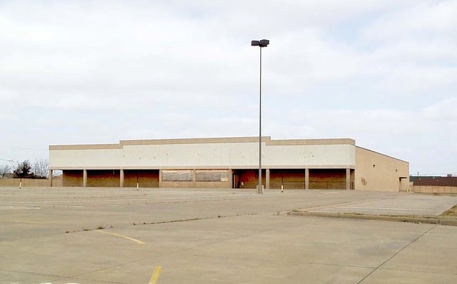
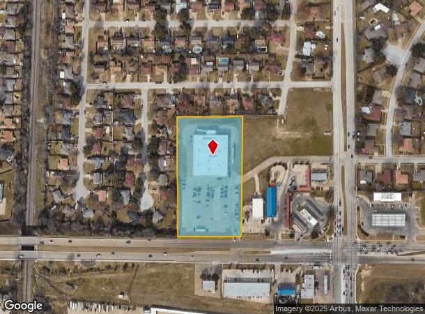
Property Record
2100 Altamesa Blvd, Fort Worth, TX 76134
NEARBY LISTINGS FOR SALE OR LEASE
Property Detail
2100 Altamesa Blvd
Dallas-Fort Worth-Arlington, TX
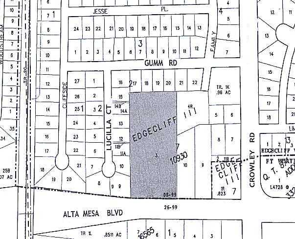
Edgecliff Iii Addition
06455875
EDGECLIFF III ADDITION BLOCK 7 LOT 3
Commercialnec
Tarrant
X
Texas
48439C0315L
3
0
4 AC
2025
Southwest Fort Worth
111003
Dallas/Ft Worth
29,083 SF
DEMOGRAPHICS near 2100 Altamesa Blvd
1 Mile
3 Mile
5 Mile
2024 Total Population
16,782
120,105
280,984
2029 Population
17,578
126,317
296,766
Pop Growth 2024-2029
+ 4.74%
+ 5.17%
+ 5.62%
Average Age
36
36
36
2024 Total Households
5,774
40,029
96,775
HH Growth 2024-2029
+ 4.75%
+ 5.16%
+ 5.77%
Median Household Inc
$54,970
$60,438
$62,195
Avg Household Size
2.90
2.90
2.80
2024 Avg HH Vehicles
2.00
2.00
2.00
Median Home Value
$177,415
$194,066
$224,755
Median Year Built
1982
1978
1983
Nearby Places
Map Layers
Map Styles
 Street
 Aerial
- Restaurants
- Banks
- Shops
- Fitness
- Groceries
PUBLIC TRANSPORTATION
COMMUTER RAIL
Texas And Pacific (T&P) (Trinity Railway Express - Dallas Area Rapid Transit (DART))
DRIVE
WALK
Distance
Texas And Pacific (T&P) (Trinity Railway Express - Dallas Area Rapid Transit (DART))
14 min
8.9 mi
DRIVE
WALK
Distance
15 min
9.1 mi
AIRPORT
Dallas-Fort Worth International
DRIVE
WALK
Distance
Dallas-Fort Worth International
45 min
33.1 mi
Dallas Love Field
DRIVE
WALK
Distance
Dallas Love Field
56 min
41.8 mi
Nearby Properties
Address
Land Use
TOTAL SIZE
Lot Size
Zoning
Address
Land Use
TOTAL SIZE
Lot Size
Zoning
1,623,188 SF
84.13 AC
Address
Land Use
TOTAL SIZE
Lot Size
Zoning
948,833 SF
64.37 AC
Address
Land Use
TOTAL SIZE
Lot Size
Zoning
1,129,204 SF
74.34 AC
Address
Land Use
TOTAL SIZE
Lot Size
Zoning
781,200 SF
37.80 AC
Address
Land Use
TOTAL SIZE
Lot Size
Zoning
1,126,017 SF
76.27 AC
Address
Land Use
TOTAL SIZE
Lot Size
Zoning
655,500 SF
38.98 AC
Address
Land Use
TOTAL SIZE
Lot Size
Zoning
660,000 SF
33.91 AC
Address
Land Use
TOTAL SIZE
Lot Size
Zoning
647,228 SF
31.47 AC
Address
Land Use
TOTAL SIZE
Lot Size
Zoning
615,250 SF
32.43 AC
Address
Land Use
TOTAL SIZE
Lot Size
Zoning
319,017 SF
14.68 AC
Address
Land Use
TOTAL SIZE
Lot Size
Zoning
655,500 SF
35.45 AC
Address
Land Use
TOTAL SIZE
Lot Size
Zoning
193,098 SF
25 AC
Address
Land Use
TOTAL SIZE
Lot Size
Zoning
462,777 SF
37.49 AC
Address
Land Use
TOTAL SIZE
Lot Size
Zoning
266,514 SF
14.06 AC
Address
Land Use
TOTAL SIZE
Lot Size
Zoning
615,054 SF
27.49 AC
Address
Land Use
TOTAL SIZE
Lot Size
Zoning
489,679 SF
27.08 AC
Address
Land Use
TOTAL SIZE
Lot Size
Zoning
455,000 SF
6 AC
Address
Land Use
TOTAL SIZE
Lot Size
Zoning
562,944 SF
35.69 AC
Address
Land Use
TOTAL SIZE
Lot Size
Zoning
147,466 SF
19.19 AC
Address
Land Use
TOTAL SIZE
Lot Size
Zoning
619,649 SF
53.64 AC
Address
Land Use
TOTAL SIZE
Lot Size
Zoning
585,000 SF
28.75 AC
Address
Land Use
TOTAL SIZE
Lot Size
Zoning
456,500 SF
29.55 AC
Address
Land Use
TOTAL SIZE
Lot Size
Zoning
865,460 SF
41.14 AC
Address
Land Use
TOTAL SIZE
Lot Size
Zoning
234,747 SF
9.11 AC
Address
Land Use
TOTAL SIZE
Lot Size
Zoning
391,540 SF
21.17 AC
Address
Land Use
TOTAL SIZE
Lot Size
Zoning
230,452 SF
63.63 AC
Address
Land Use
TOTAL SIZE
Lot Size
Zoning
182,258 SF
9.33 AC
Address
Land Use
TOTAL SIZE
Lot Size
Zoning
765,351 SF
40.31 AC
Address
Land Use
TOTAL SIZE
Lot Size
Zoning
374,874 SF
23.59 AC
Address
Land Use
TOTAL SIZE
Lot Size
Zoning
186,352 SF
11.01 AC
The World's #1 Commercial Real Estate Marketplace
Connect with us
© 2026 CoStar Group
The information above has been obtained from sources believed reliable. While we do not doubt its accuracy we have not verified it and make no guarantee, warranty or representation about it. It is your responsibility to independently confirm its accuracy and completeness. Any projections, opinions, assumptions, or estimates used are for example only and do not represent the current or future performance of the property. The value of this transaction to you depends on tax and other factors which should be evaluated by your tax, financial, and legal advisors. You and your advisors should conduct a careful, independent investigation of the property to determine to your satisfaction the suitability of the property for your needs.