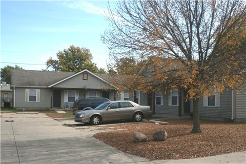
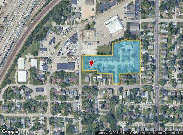
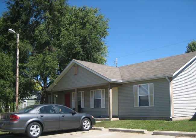
Property Record
2100 Banstead Ct, Lafayette, IN 47904
NEARBY LISTINGS FOR SALE OR LEASE
Property Detail
2100 Banstead Ct
Lafayette-West Lafayette, IN
Northfield Commons Sd
79-07-16-821-003.000-004
NORTHFIELD COMMONS SD REPLAT LOT 1A REPLAT OF LOT 2 STAR LANES SD & LOTS27-32 FR EDA GAASCHS ADDN
Apartment
Tippecanoe
X
Indiana
18157C0134D
1a,2
2024
3.12 AC
2024
Lafayette/Kokomo
000100
Other Market Areas
26,992 SF
DEMOGRAPHICS near 2100 Banstead Ct
1 Mile
3 Mile
5 Mile
2024 Total Population
9,753
76,854
141,320
2029 Population
10,013
79,403
145,831
Pop Growth 2024-2029
+ 2.67%
+ 3.32%
+ 3.19%
Average Age
37
34
35
2024 Total Households
3,941
30,637
57,520
HH Growth 2024-2029
+ 2.74%
+ 3.82%
+ 3.50%
Median Household Inc
$39,792
$40,425
$46,999
Avg Household Size
2.20
2.10
2.20
2024 Avg HH Vehicles
1.00
2.00
2.00
Median Home Value
$77,975
$177,925
$182,671
Median Year Built
1955
1973
1984
Nearby Places
Map Layers
Map Styles
 Street
 Aerial
- Restaurants
- Banks
- Shops
- Fitness
- Groceries
PUBLIC TRANSPORTATION
COMMUTER RAIL
Lafayette Amtrak Station (Cardinal - Amtrak)
DRIVE
WALK
Distance
Lafayette Amtrak Station (Cardinal - Amtrak)
5 min
2.0 mi
Freight Ports
Port Milwaukee
DRIVE
WALK
Distance
Port Milwaukee
246 min
205.9 mi
SALE & LEASE HISTORY
LISTING DATE
SALE/LEASE

Jan 30, 2018
For Sale
Nearby Properties
Address
Land Use
TOTAL SIZE
Lot Size
Zoning
Address
Land Use
TOTAL SIZE
Lot Size
Zoning
469,872 SF
0.85 AC
Address
Land Use
TOTAL SIZE
Lot Size
Zoning
377,937 SF
4.80 AC
Address
Land Use
TOTAL SIZE
Lot Size
Zoning
385,162 SF
1 AC
Address
Land Use
TOTAL SIZE
Lot Size
Zoning
401,345 SF
1.64 AC
Address
Land Use
TOTAL SIZE
Lot Size
Zoning
498,665 SF
1.94 AC
Address
Land Use
TOTAL SIZE
Lot Size
Zoning
Address
Land Use
TOTAL SIZE
Lot Size
Zoning
417,720 SF
3.09 AC
Address
Land Use
TOTAL SIZE
Lot Size
Zoning
249,214 SF
1.93 AC
Address
Land Use
TOTAL SIZE
Lot Size
Zoning
402,757 SF
23.10 AC
Address
Land Use
TOTAL SIZE
Lot Size
Zoning
159,723 SF
4.87 AC
Address
Land Use
TOTAL SIZE
Lot Size
Zoning
148,860 SF
1.25 AC
Address
Land Use
TOTAL SIZE
Lot Size
Zoning
210,829 SF
87 SF
Address
Land Use
TOTAL SIZE
Lot Size
Zoning
0.01 AC
Address
Land Use
TOTAL SIZE
Lot Size
Zoning
232,565 SF
1.15 AC
Address
Land Use
TOTAL SIZE
Lot Size
Zoning
1,449,360 SF
0.01 AC
Address
Land Use
TOTAL SIZE
Lot Size
Zoning
205,701 SF
1.27 AC
Address
Land Use
TOTAL SIZE
Lot Size
Zoning
27,300 SF
22.52 AC
Address
Land Use
TOTAL SIZE
Lot Size
Zoning
164,234 SF
0.88 AC
Address
Land Use
TOTAL SIZE
Lot Size
Zoning
184,441 SF
44 SF
Address
Land Use
TOTAL SIZE
Lot Size
Zoning
222,276 SF
0.31 AC
Address
Land Use
TOTAL SIZE
Lot Size
Zoning
141,960 SF
2.27 AC
Address
Land Use
TOTAL SIZE
Lot Size
Zoning
118,066 SF
0.80 AC
Address
Land Use
TOTAL SIZE
Lot Size
Zoning
135,090 SF
0.80 AC
Address
Land Use
TOTAL SIZE
Lot Size
Zoning
1,409,410 SF
170.04 AC
Address
Land Use
TOTAL SIZE
Lot Size
Zoning
133,379 SF
44 SF
Address
Land Use
TOTAL SIZE
Lot Size
Zoning
109,515 SF
0.85 AC
Address
Land Use
TOTAL SIZE
Lot Size
Zoning
251,709 SF
87 SF
Address
Land Use
TOTAL SIZE
Lot Size
Zoning
72,739 SF
1.46 AC
Address
Land Use
TOTAL SIZE
Lot Size
Zoning
109,876 SF
0.61 AC
The World's #1 Commercial Real Estate Marketplace
Connect with us
© 2026 CoStar Group
The information above has been obtained from sources believed reliable. While we do not doubt its accuracy we have not verified it and make no guarantee, warranty or representation about it. It is your responsibility to independently confirm its accuracy and completeness. Any projections, opinions, assumptions, or estimates used are for example only and do not represent the current or future performance of the property. The value of this transaction to you depends on tax and other factors which should be evaluated by your tax, financial, and legal advisors. You and your advisors should conduct a careful, independent investigation of the property to determine to your satisfaction the suitability of the property for your needs.