Property Record
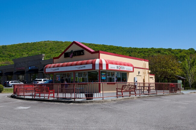
2100 Cecil Ashburn Dr Se, Huntsville, AL 35802


NEARBY LISTINGS FOR SALE OR LEASE
Property Detail
2100 Cecil Ashburn Dr Se
Huntsville, AL
Plaza At Four Mile Post 2Nd
18-05-21-0-000-006.003
LOT 1 PLAZA AT FOUR MILE POST 2ND ADDITION PB 47 PG 94
Restaurantdrivein
Madison
X
Alabama
01089C0341G
1
2025
0.91 AC
2025
South Huntsville
002722
Huntsville
1,008 SF
DEMOGRAPHICS near 2100 Cecil Ashburn Dr Se
1 Mile
3 Mile
5 Mile
2024 Total Population
4,252
36,780
93,021
2029 Population
4,719
40,488
102,659
Pop Growth 2024-2029
+ 10.98%
+ 10.08%
+ 10.36%
Average Age
48
44
42
2024 Total Households
1,852
16,545
39,874
HH Growth 2024-2029
+ 11.39%
+ 10.42%
+ 10.80%
Median Household Inc
$106,250
$85,982
$88,492
Avg Household Size
2.20
2.10
2.20
2024 Avg HH Vehicles
2.00
2.00
2.00
Median Home Value
$296,946
$297,249
$304,789
Median Year Built
1977
1979
1981
Nearby Places
Map Layers
Map Styles
 Street
 Aerial
- Restaurants
- Banks
- Shops
- Fitness
- Groceries
PUBLIC TRANSPORTATION
AIRPORT
Huntsville International-Carl T Jones Field
DRIVE
WALK
Distance
Huntsville International-Carl T Jones Field
31 min
19.1 mi
SALE & LEASE HISTORY
LISTING DATE
SALE/LEASE

Apr 21, 2023
For Sale
Nearby Properties
Address
Land Use
TOTAL SIZE
Lot Size
Zoning
Address
Land Use
TOTAL SIZE
Lot Size
Zoning
67,868 SF
11 AC
Address
Land Use
TOTAL SIZE
Lot Size
Zoning
5,136 SF
22 AC
Address
Land Use
TOTAL SIZE
Lot Size
Zoning
184,300 SF
23 AC
Address
Land Use
TOTAL SIZE
Lot Size
Zoning
97,422 SF
10.77 AC
Address
Land Use
TOTAL SIZE
Lot Size
Zoning
4,379 SF
18 AC
Address
Land Use
TOTAL SIZE
Lot Size
Zoning
57,281 SF
25 AC
Address
Land Use
TOTAL SIZE
Lot Size
Zoning
3,168 SF
25.32 AC
Address
Land Use
TOTAL SIZE
Lot Size
Zoning
86,928 SF
10.42 AC
Address
Land Use
TOTAL SIZE
Lot Size
Zoning
32,879 SF
14 AC
Address
Land Use
TOTAL SIZE
Lot Size
Zoning
29,481 SF
29 AC
Address
Land Use
TOTAL SIZE
Lot Size
Zoning
58,809 SF
9.90 AC
Address
Land Use
TOTAL SIZE
Lot Size
Zoning
11,772 SF
18.18 AC
Address
Land Use
TOTAL SIZE
Lot Size
Zoning
62,541 SF
25 AC
Address
Land Use
TOTAL SIZE
Lot Size
Zoning
2,932 SF
36.63 AC
Address
Land Use
TOTAL SIZE
Lot Size
Zoning
3,655 SF
10.75 AC
Address
Land Use
TOTAL SIZE
Lot Size
Zoning
1,540 SF
20.65 AC
Address
Land Use
TOTAL SIZE
Lot Size
Zoning
5,785 SF
12.86 AC
Address
Land Use
TOTAL SIZE
Lot Size
Zoning
1,325 SF
14.84 AC
Address
Land Use
TOTAL SIZE
Lot Size
Zoning
8,580 SF
19.29 AC
Address
Land Use
TOTAL SIZE
Lot Size
Zoning
115,232 SF
11 AC
Address
Land Use
TOTAL SIZE
Lot Size
Zoning
54,064 SF
13.46 AC
Address
Land Use
TOTAL SIZE
Lot Size
Zoning
135,243 SF
12.07 AC
Address
Land Use
TOTAL SIZE
Lot Size
Zoning
175,364 SF
13.18 AC
Address
Land Use
TOTAL SIZE
Lot Size
Zoning
15,000 SF
13.54 AC
Address
Land Use
TOTAL SIZE
Lot Size
Zoning
2,475 SF
11.77 AC
Address
Land Use
TOTAL SIZE
Lot Size
Zoning
41,354 SF
2.62 AC
Address
Land Use
TOTAL SIZE
Lot Size
Zoning
130,448 SF
16.93 AC
Address
Land Use
TOTAL SIZE
Lot Size
Zoning
3,604 SF
9.24 AC
Address
Land Use
TOTAL SIZE
Lot Size
Zoning
63,648 SF
6.20 AC
Address
Land Use
TOTAL SIZE
Lot Size
Zoning
4,719 SF
6.94 AC
The World's #1 Commercial Real Estate Marketplace
Connect with us
© 2026 CoStar Group
The information above has been obtained from sources believed reliable. While we do not doubt its accuracy we have not verified it and make no guarantee, warranty or representation about it. It is your responsibility to independently confirm its accuracy and completeness. Any projections, opinions, assumptions, or estimates used are for example only and do not represent the current or future performance of the property. The value of this transaction to you depends on tax and other factors which should be evaluated by your tax, financial, and legal advisors. You and your advisors should conduct a careful, independent investigation of the property to determine to your satisfaction the suitability of the property for your needs.