Property Record
2100 Cliff Rd E, Burnsville, MN 55337
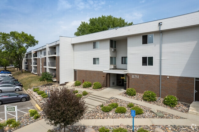
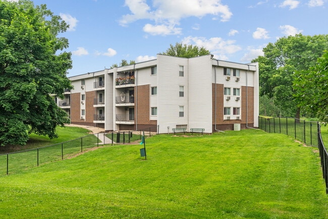

Property Detail
2100 Cliff Rd E
Minneapolis-St. Paul-Bloomington, MN-WI
MILLPOND ADDITION 2 1
02-48500-01-010
DAKOTA
Apartment
Minnesota
B and X Area of moderate flood hazard, usually the area between the limits of the 100-year and 500-year floods.
20
2025
9.18 AC
2025
Eagan/Burnsvle/Inner Gr Hts/W St Paul
060747
Minneapolis/St Paul
178,425 SF
NEARBY LISTINGS FOR SALE OR LEASE
-
-
View all Burnsville listings for sale on LoopNet.com
DEMOGRAPHICS near 2100 Cliff Rd E
1 mile
3 mile
5 mile
2025 Total Population
10,701
72,935
200,196
2030 Population
10,797
74,546
203,695
Pop Growth 2025-2030
+ 0.90%
+ 2.21%
+ 1.75%
Average Age
39
41
41
2025 Total Households
4,434
30,063
80,423
HH Growth 2025-2030
+ 1.08%
+ 2.40%
+ 1.93%
Median Household Inc
$82,798
$83,450
$88,676
Avg Household Size
2.40
2.30
2.40
2025 Avg HH Vehicles
2.00
2.00
2.00
Median Home Value
$324,760
$347,967
$358,796
Median Year Built
1978
1980
1980
Nearby Places
Map Layers
Map Styles
 Street
 Aerial
Layers
 Traffic
 Biking
Places
Listings with unknown addresses are not visible on the map
- Restaurants
- Banks
- Shops
- Fitness
- Groceries
PUBLIC TRANSPORTATION
AIRPORT
Minneapolis-St Paul International/Wold-Chamberlain
Drive
Walk
Distance
Minneapolis-St Paul International/Wold-Chamberlain
16 min
8.5 mi
Nearby Properties
Address
Land Use
TOTAL SIZE
Lot Size
Zoning
Address
Land Use
TOTAL SIZE
Lot Size
Zoning
1,341.19 AC
Address
Land Use
TOTAL SIZE
Lot Size
Zoning
752,064 SF
24.03 AC
Address
Land Use
TOTAL SIZE
Lot Size
Zoning
300,663 SF
4.81 AC
Address
Land Use
TOTAL SIZE
Lot Size
Zoning
168,729 SF
19.02 AC
Address
Land Use
TOTAL SIZE
Lot Size
Zoning
584,692 SF
15.70 AC
Address
Land Use
TOTAL SIZE
Lot Size
Zoning
230,883 SF
2.49 AC
Address
Land Use
TOTAL SIZE
Lot Size
Zoning
263,460 SF
3.08 AC
Address
Land Use
TOTAL SIZE
Lot Size
Zoning
282,095 SF
2.71 AC
Address
Land Use
TOTAL SIZE
Lot Size
Zoning
24,750 SF
14.36 AC
Address
Land Use
TOTAL SIZE
Lot Size
Zoning
299,435 SF
7.65 AC
Address
Land Use
TOTAL SIZE
Lot Size
Zoning
374,415 SF
20.10 AC
Address
Land Use
TOTAL SIZE
Lot Size
Zoning
192,843 SF
13.32 AC
Address
Land Use
TOTAL SIZE
Lot Size
Zoning
177,489 SF
1.75 AC
Address
Land Use
TOTAL SIZE
Lot Size
Zoning
216,267 SF
3.69 AC
Address
Land Use
TOTAL SIZE
Lot Size
Zoning
134,298 SF
16.70 AC
Address
Land Use
TOTAL SIZE
Lot Size
Zoning
174,245 SF
2.90 AC
Address
Land Use
TOTAL SIZE
Lot Size
Zoning
287,255 SF
14.69 AC
Address
Land Use
TOTAL SIZE
Lot Size
Zoning
234,348 SF
11.21 AC
Address
Land Use
TOTAL SIZE
Lot Size
Zoning
201,481 SF
6.69 AC
Address
Land Use
TOTAL SIZE
Lot Size
Zoning
260,290 SF
13.28 AC
Address
Land Use
TOTAL SIZE
Lot Size
Zoning
256,907 SF
7.43 AC
Address
Land Use
TOTAL SIZE
Lot Size
Zoning
112.48 AC
Address
Land Use
TOTAL SIZE
Lot Size
Zoning
231,928 SF
16.63 AC
Address
Land Use
TOTAL SIZE
Lot Size
Zoning
62,165 SF
13.21 AC
Address
Land Use
TOTAL SIZE
Lot Size
Zoning
158,620 SF
1.80 AC
Address
Land Use
TOTAL SIZE
Lot Size
Zoning
173,095 SF
9.43 AC
Address
Land Use
TOTAL SIZE
Lot Size
Zoning
134,140 SF
6.39 AC
Address
Land Use
TOTAL SIZE
Lot Size
Zoning
239,396 SF
9.68 AC
The World's #1 Commercial Real Estate Marketplace
Connect with us
© 2026 CoStar Group
The information above has been obtained from sources believed reliable. While we do not doubt its accuracy we have not verified it and make no guarantee, warranty or representation about it. It is your responsibility to independently confirm its accuracy and completeness. Any projections, opinions, assumptions, or estimates used are for example only and do not represent the current or future performance of the property. The value of this transaction to you depends on tax and other factors which should be evaluated by your tax, financial, and legal advisors. You and your advisors should conduct a careful, independent investigation of the property to determine to your satisfaction the suitability of the property for your needs.