Property Record
2600 E 5Th Ave, Gary, IN 46402
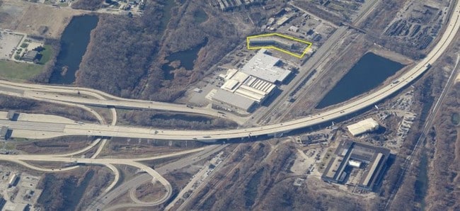

Property Detail
2600 E 5Th Ave
Chicago-Naperville-Elgin, IL-IN
PT. SW. S. OF DUNES HWY S.2 T.36 R.8 13.232 AC
45-08-02-376-006.000-004
Lake
Warehouse
Indiana
B and X Area of moderate flood hazard, usually the area between the limits of the 100-year and 500-year floods.
1
2024
13.23 AC
2025
Indiana
011400
Chicago
202,051 SF
NEARBY LISTINGS FOR SALE OR LEASE
DEMOGRAPHICS near 2600 E 5Th Ave
1 mile
3 mile
5 mile
2025 Total Population
2,546
40,615
106,068
2030 Population
2,702
42,878
110,403
Pop Growth 2025-2030
+ 6.13%
+ 5.57%
+ 4.09%
Average Age
38
40
40
2025 Total Households
1,029
17,350
43,039
HH Growth 2025-2030
+ 6.12%
+ 5.57%
+ 4.11%
Median Household Inc
$28,192
$33,689
$45,259
Avg Household Size
2.40
2.30
2.40
2025 Avg HH Vehicles
1.00
1.00
1.00
Median Home Value
$92,307
$88,507
$129,247
Median Year Built
1950
1955
1958
Nearby Places
Map Layers
Map Styles
 Street
 Aerial
Transit
 Traffic
 Biking
Places
Listings with unknown addresses are not visible on the map
- Restaurants
- Banks
- Shops
- Fitness
- Groceries
PUBLIC TRANSPORTATION
COMMUTER RAIL
Miller (Gary) Station (South Shore Line - Northern Indiana Commuter Transportation District (South Shore Line))
Drive
Walk
Distance
Miller (Gary) Station (South Shore Line - Northern Indiana Commuter Transportation District (South Shore Line))
4 min
2.3 mi
Gary Metro Center Station (South Shore Line - Northern Indiana Commuter Transportation District (South Shore Line))
Drive
Walk
Distance
Gary Metro Center Station (South Shore Line - Northern Indiana Commuter Transportation District (South Shore Line))
6 min
4.2 mi
AIRPORT
Chicago Midway International
Drive
Walk
Distance
Chicago Midway International
47 min
31.3 mi
Freight Ports
Port Milwaukee
Drive
Walk
Distance
Port Milwaukee
147 min
116.6 mi
SALE & LEASE HISTORY
LISTING DATE
SALE/LEASE

Jun 09, 2020
For Sale
Aug 29, 2019
For Lease
Nearby Properties
Address
Land Use
TOTAL SIZE
Lot Size
Zoning
Address
Land Use
TOTAL SIZE
Lot Size
Zoning
1,494,993 SF
0.73 AC
Address
Land Use
TOTAL SIZE
Lot Size
Zoning
11,251,614 SF
280.05 AC
Address
Land Use
TOTAL SIZE
Lot Size
Zoning
2,465,723 SF
214.61 AC
Address
Land Use
TOTAL SIZE
Lot Size
Zoning
1,031,903 SF
53.44 AC
Address
Land Use
TOTAL SIZE
Lot Size
Zoning
164,916 SF
R33
Address
Land Use
TOTAL SIZE
Lot Size
Zoning
1,269,933 SF
231.44 AC
Address
Land Use
TOTAL SIZE
Lot Size
Zoning
530,887 SF
141.40 AC
Address
Land Use
TOTAL SIZE
Lot Size
Zoning
140,080 SF
12.83 AC
Address
Land Use
TOTAL SIZE
Lot Size
Zoning
6,356 SF
454.89 AC
Address
Land Use
TOTAL SIZE
Lot Size
Zoning
792,948 SF
309.09 AC
Address
Land Use
TOTAL SIZE
Lot Size
Zoning
198,129 SF
81.48 AC
Address
Land Use
TOTAL SIZE
Lot Size
Zoning
1,864,286 SF
119.61 AC
Address
Land Use
TOTAL SIZE
Lot Size
Zoning
156,754 SF
2.16 AC
Address
Land Use
TOTAL SIZE
Lot Size
Zoning
79,216 SF
4.59 AC
Address
Land Use
TOTAL SIZE
Lot Size
Zoning
64,872 SF
1.70 AC
Address
Land Use
TOTAL SIZE
Lot Size
Zoning
410,295 SF
190.01 AC
Address
Land Use
TOTAL SIZE
Lot Size
Zoning
130,391 SF
42.66 AC
Address
Land Use
TOTAL SIZE
Lot Size
Zoning
47,742 SF
0.52 AC
Address
Land Use
TOTAL SIZE
Lot Size
Zoning
38,400 SF
4.51 AC
Address
Land Use
TOTAL SIZE
Lot Size
Zoning
155,861 SF
30.91 AC
Address
Land Use
TOTAL SIZE
Lot Size
Zoning
78,628 SF
6.20 AC
Address
Land Use
TOTAL SIZE
Lot Size
Zoning
45,732 SF
4.35 AC
Address
Land Use
TOTAL SIZE
Lot Size
Zoning
89,550 SF
7.12 AC
Address
Land Use
TOTAL SIZE
Lot Size
Zoning
69,526 SF
6.95 AC
Address
Land Use
TOTAL SIZE
Lot Size
Zoning
49,167 SF
2.85 AC
Address
Land Use
TOTAL SIZE
Lot Size
Zoning
408,300 SF
10.80 AC
Address
Land Use
TOTAL SIZE
Lot Size
Zoning
39,414 SF
1.69 AC
Address
Land Use
TOTAL SIZE
Lot Size
Zoning
106,780 SF
3.72 AC
Address
Land Use
TOTAL SIZE
Lot Size
Zoning
107,494 SF
36.95 AC
Address
Land Use
TOTAL SIZE
Lot Size
Zoning
60,606 SF
1.30 AC
The World's #1 Commercial Real Estate Marketplace
Connect with us
© 2026 CoStar Group
The information above has been obtained from sources believed reliable. While we do not doubt its accuracy we have not verified it and make no guarantee, warranty or representation about it. It is your responsibility to independently confirm its accuracy and completeness. Any projections, opinions, assumptions, or estimates used are for example only and do not represent the current or future performance of the property. The value of this transaction to you depends on tax and other factors which should be evaluated by your tax, financial, and legal advisors. You and your advisors should conduct a careful, independent investigation of the property to determine to your satisfaction the suitability of the property for your needs.