Property Record
2100 E Highway 119 Blvd, Longmont, CO 80504
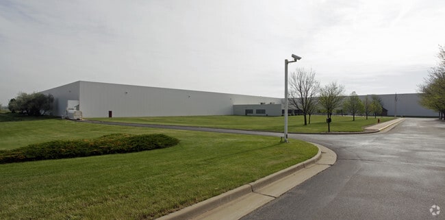

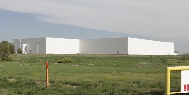
Property Detail
2100 E Highway 119 Blvd
Greeley, CO
LOG MCL-1 L1 MC LANE ADD ALSO OUTLOT A (1.17 AC. RR R/W) & OUTLOT B (4.45 AC. DITCH R/W)
R0053991
WELD
Warehouse
Colorado
B and X Area of moderate flood hazard, usually the area between the limits of the 100-year and 500-year floods.
1
2024
143.20 AC
2025
Weld County
002105
Denver
333,909 SF
NEARBY LISTINGS FOR SALE OR LEASE
DEMOGRAPHICS near 2100 E Highway 119 Blvd
1 mile
3 mile
5 mile
2024 Total Population
5,829
42,280
94,958
2029 Population
6,153
42,576
96,408
Pop Growth 2024-2029
+ 5.56%
+ 0.70%
+ 1.53%
Average Age
42
40
41
2024 Total Households
2,460
16,406
37,487
HH Growth 2024-2029
+ 5.45%
+ 0.84%
+ 1.48%
Median Household Inc
$99,380
$89,925
$87,950
Avg Household Size
2.30
2.50
2.50
2024 Avg HH Vehicles
2.00
2.00
2.00
Median Home Value
$612,953
$587,398
$617,860
Median Year Built
2006
1993
1989
Nearby Places
Map Layers
Map Styles
 Street
 Aerial
Transit
 Traffic
 Biking
Places
Listings with unknown addresses are not visible on the map
- Restaurants
- Banks
- Shops
- Fitness
- Groceries
PUBLIC TRANSPORTATION
AIRPORT
Denver International
Drive
Walk
Distance
Denver International
48 min
41.4 mi
Freight Ports
Tulsa Port Of Catoosa
Drive
Walk
Distance
Tulsa Port Of Catoosa
754 min
735.5 mi
Nearby Properties
Address
Land Use
TOTAL SIZE
Lot Size
Zoning
Address
Land Use
TOTAL SIZE
Lot Size
Zoning
638,659 SF
62.59 AC
Address
Land Use
TOTAL SIZE
Lot Size
Zoning
219,393 SF
25.13 AC
Address
Land Use
TOTAL SIZE
Lot Size
Zoning
73.36 AC
A
Address
Land Use
TOTAL SIZE
Lot Size
Zoning
1,092 SF
150.73 AC
A
Address
Land Use
TOTAL SIZE
Lot Size
Zoning
146.34 AC
A
Address
Land Use
TOTAL SIZE
Lot Size
Zoning
34,137 SF
19.99 AC
Address
Land Use
TOTAL SIZE
Lot Size
Zoning
75.02 AC
A
Address
Land Use
TOTAL SIZE
Lot Size
Zoning
139.01 AC
A
Address
Land Use
TOTAL SIZE
Lot Size
Zoning
54.45 AC
Address
Land Use
TOTAL SIZE
Lot Size
Zoning
45.32 AC
Address
Land Use
TOTAL SIZE
Lot Size
Zoning
277,321 SF
14.96 AC
Address
Land Use
TOTAL SIZE
Lot Size
Zoning
33.81 AC
Address
Land Use
TOTAL SIZE
Lot Size
Zoning
83.57 AC
A
Address
Land Use
TOTAL SIZE
Lot Size
Zoning
146,153 SF
13.60 AC
Address
Land Use
TOTAL SIZE
Lot Size
Zoning
1,000 SF
71.43 AC
A
Address
Land Use
TOTAL SIZE
Lot Size
Zoning
133,569 SF
14.67 AC
Address
Land Use
TOTAL SIZE
Lot Size
Zoning
13.93 AC
Address
Land Use
TOTAL SIZE
Lot Size
Zoning
199,578 SF
12.94 AC
Address
Land Use
TOTAL SIZE
Lot Size
Zoning
358,412 SF
13.52 AC
Address
Land Use
TOTAL SIZE
Lot Size
Zoning
126,601 SF
13.39 AC
Address
Land Use
TOTAL SIZE
Lot Size
Zoning
215,229 SF
25.58 AC
Address
Land Use
TOTAL SIZE
Lot Size
Zoning
49.99 AC
A
Address
Land Use
TOTAL SIZE
Lot Size
Zoning
9.73 AC
Address
Land Use
TOTAL SIZE
Lot Size
Zoning
105,141 SF
11.80 AC
Address
Land Use
TOTAL SIZE
Lot Size
Zoning
44,880 SF
0.65 AC
Address
Land Use
TOTAL SIZE
Lot Size
Zoning
86,459 SF
3.19 AC
Address
Land Use
TOTAL SIZE
Lot Size
Zoning
267,724 SF
5.85 AC
Address
Land Use
TOTAL SIZE
Lot Size
Zoning
8.90 AC
Address
Land Use
TOTAL SIZE
Lot Size
Zoning
The World's #1 Commercial Real Estate Marketplace
Connect with us
© 2026 CoStar Group
The information above has been obtained from sources believed reliable. While we do not doubt its accuracy we have not verified it and make no guarantee, warranty or representation about it. It is your responsibility to independently confirm its accuracy and completeness. Any projections, opinions, assumptions, or estimates used are for example only and do not represent the current or future performance of the property. The value of this transaction to you depends on tax and other factors which should be evaluated by your tax, financial, and legal advisors. You and your advisors should conduct a careful, independent investigation of the property to determine to your satisfaction the suitability of the property for your needs.