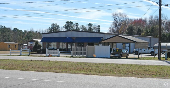
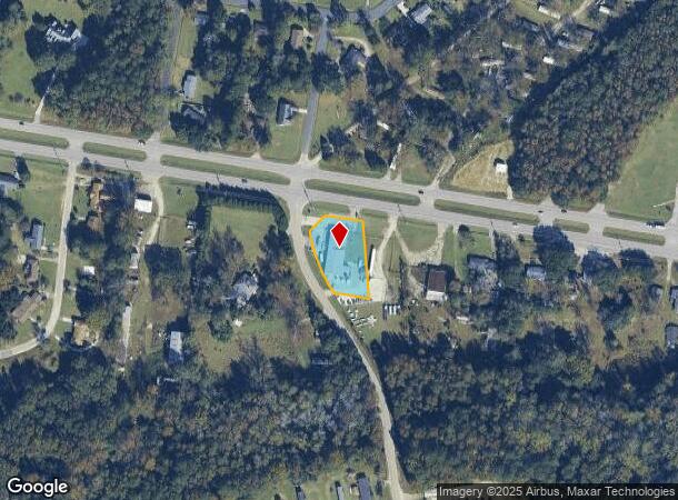
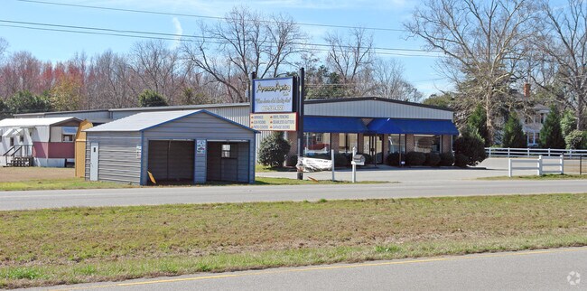
Property Record
2100 Five Chop Rd, Orangeburg, SC 29115
NEARBY LISTINGS FOR SALE OR LEASE
-
-
View all Orangeburg listings for sale on LoopNet.com
Property Detail
2100 Five Chop Rd
0206-00-06-053.000
Lm Bradshaw By Edisto Surveyors Inc
Commercialnec
S-38-1520 POR OF PARCEL D
X
Orangeburg
45075C0381C
South Carolina
2024
0.70 AC
2024
Other Market Areas
010603
Orangeburg, SC
7,100 SF
DEMOGRAPHICS near 2100 Five Chop Rd
1 Mile
3 Mile
5 Mile
2024 Total Population
601
5,592
23,323
2029 Population
585
5,564
23,145
Pop Growth 2024-2029
(2.66%)
(0.50%)
(0.76%)
Average Age
41
41
38
2024 Total Households
243
2,231
8,534
HH Growth 2024-2029
(2.47%)
(0.36%)
(0.75%)
Median Household Inc
$42,424
$28,171
$24,335
Avg Household Size
2.40
2.40
2.20
2024 Avg HH Vehicles
2.00
2.00
2.00
Median Home Value
$117,500
$85,651
$84,950
Median Year Built
1981
1979
1975
Nearby Places
Map Layers
Map Styles
 Street
 Aerial
- Restaurants
- Banks
- Shops
- Fitness
- Groceries
SALE & LEASE HISTORY
LISTING DATE
SALE/LEASE

Jul 26, 2018
For Sale
Jan 23, 2017
For Sale
Nearby Properties
Address
Land Use
TOTAL SIZE
Lot Size
Zoning
Address
Land Use
TOTAL SIZE
Lot Size
Zoning
205,299 SF
44.40 AC
Address
Land Use
TOTAL SIZE
Lot Size
Zoning
9,358 SF
2.20 AC
Address
Land Use
TOTAL SIZE
Lot Size
Zoning
7,500 SF
6 AC
Address
Land Use
TOTAL SIZE
Lot Size
Zoning
480 SF
24.99 AC
Address
Land Use
TOTAL SIZE
Lot Size
Zoning
18,200 SF
15.50 AC
Address
Land Use
TOTAL SIZE
Lot Size
Zoning
198 SF
28.98 AC
Address
Land Use
TOTAL SIZE
Lot Size
Zoning
130,225 SF
26.50 AC
Address
Land Use
TOTAL SIZE
Lot Size
Zoning
2,464 SF
6.50 AC
Address
Land Use
TOTAL SIZE
Lot Size
Zoning
223,600 SF
26.70 AC
Address
Land Use
TOTAL SIZE
Lot Size
Zoning
158,667 SF
12 AC
Address
Land Use
TOTAL SIZE
Lot Size
Zoning
Address
Land Use
TOTAL SIZE
Lot Size
Zoning
Address
Land Use
TOTAL SIZE
Lot Size
Zoning
8,995 SF
1.90 AC
Address
Land Use
TOTAL SIZE
Lot Size
Zoning
28,273 SF
2.33 AC
Address
Land Use
TOTAL SIZE
Lot Size
Zoning
10,848 SF
6.10 AC
Address
Land Use
TOTAL SIZE
Lot Size
Zoning
10,920 SF
3.30 AC
Address
Land Use
TOTAL SIZE
Lot Size
Zoning
9,020 SF
2.02 AC
Address
Land Use
TOTAL SIZE
Lot Size
Zoning
26,920 SF
4.11 AC
Address
Land Use
TOTAL SIZE
Lot Size
Zoning
27,024 SF
7.40 AC
Address
Land Use
TOTAL SIZE
Lot Size
Zoning
8,438 SF
6.10 AC
Address
Land Use
TOTAL SIZE
Lot Size
Zoning
6,631 SF
6 AC
Address
Land Use
TOTAL SIZE
Lot Size
Zoning
2,464 SF
2.19 AC
Address
Land Use
TOTAL SIZE
Lot Size
Zoning
24,888 SF
1.65 AC
Address
Land Use
TOTAL SIZE
Lot Size
Zoning
9,180 SF
1 AC
Address
Land Use
TOTAL SIZE
Lot Size
Zoning
30,820 SF
3 AC
Address
Land Use
TOTAL SIZE
Lot Size
Zoning
16,612 SF
2.50 AC
Address
Land Use
TOTAL SIZE
Lot Size
Zoning
2,850 SF
1.70 AC
Address
Land Use
TOTAL SIZE
Lot Size
Zoning
18,800 SF
13 AC
Address
Land Use
TOTAL SIZE
Lot Size
Zoning
81,395 SF
7.80 AC
Address
Land Use
TOTAL SIZE
Lot Size
Zoning
6,924 SF
13.60 AC
The World's #1 Commercial Real Estate Marketplace
Connect with us
© 2025 CoStar Group
The information above has been obtained from sources believed reliable. While we do not doubt its accuracy we have not verified it and make no guarantee, warranty or representation about it. It is your responsibility to independently confirm its accuracy and completeness. Any projections, opinions, assumptions, or estimates used are for example only and do not represent the current or future performance of the property. The value of this transaction to you depends on tax and other factors which should be evaluated by your tax, financial, and legal advisors. You and your advisors should conduct a careful, independent investigation of the property to determine to your satisfaction the suitability of the property for your needs.