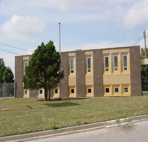
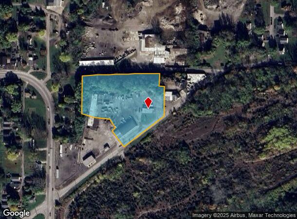
Property Record
2100 Hawkins Rd, Richmond, IN 47374
NEARBY LISTINGS FOR SALE OR LEASE
Property Detail
2100 Hawkins Rd
89-16-33-240-130.001-030
LOTS 183-193 & PT 194 & 195 ML & P PT NE SEC 33-14-1 2.773A
Officebuilding
Wayne
X
Indiana
39135C0125E
183-193
2024
3.60 AC
2024
Indiana South Area
000500
Other Market Areas
3,782 SF
Richmond, IN
DEMOGRAPHICS near 2100 Hawkins Rd
1 Mile
3 Mile
5 Mile
2024 Total Population
6,303
36,787
47,231
2029 Population
6,421
36,980
47,366
Pop Growth 2024-2029
+ 1.87%
+ 0.52%
+ 0.29%
Average Age
38
40
41
2024 Total Households
2,665
15,510
19,890
HH Growth 2024-2029
+ 1.99%
+ 0.49%
+ 0.25%
Median Household Inc
$26,152
$43,405
$45,602
Avg Household Size
2.20
2.20
2.20
2024 Avg HH Vehicles
1.00
2.00
2.00
Median Home Value
$107,356
$103,337
$114,673
Median Year Built
1948
1957
1960
Nearby Places
Map Layers
Map Styles
 Street
 Aerial
- Restaurants
- Banks
- Shops
- Fitness
- Groceries
PUBLIC TRANSPORTATION
AIRPORT
James M Cox Dayton International
DRIVE
WALK
Distance
James M Cox Dayton International
50 min
39.8 mi
SALE & LEASE HISTORY
LISTING DATE
SALE/LEASE

Sep 25, 2016
For Lease
Nearby Properties
Address
Land Use
TOTAL SIZE
Lot Size
Zoning
Address
Land Use
TOTAL SIZE
Lot Size
Zoning
171,768 SF
72.69 AC
ZO01
Address
Land Use
TOTAL SIZE
Lot Size
Zoning
1,744 SF
73.12 AC
Address
Land Use
TOTAL SIZE
Lot Size
Zoning
9,708 SF
9.11 AC
ZO01
Address
Land Use
TOTAL SIZE
Lot Size
Zoning
287,419 SF
50.34 AC
ZO01
Address
Land Use
TOTAL SIZE
Lot Size
Zoning
84,892 SF
24.43 AC
ZO01
Address
Land Use
TOTAL SIZE
Lot Size
Zoning
126,136 SF
28.16 AC
Address
Land Use
TOTAL SIZE
Lot Size
Zoning
162,366 SF
15 AC
ZO01
Address
Land Use
TOTAL SIZE
Lot Size
Zoning
6,496 SF
33.80 AC
ZO01
Address
Land Use
TOTAL SIZE
Lot Size
Zoning
562,670 SF
29.97 AC
ZO01
Address
Land Use
TOTAL SIZE
Lot Size
Zoning
2,871 SF
4.05 AC
ZO01
Address
Land Use
TOTAL SIZE
Lot Size
Zoning
46,344 SF
41.56 AC
ZO01
Address
Land Use
TOTAL SIZE
Lot Size
Zoning
137,081 SF
13.39 AC
ZO01
Address
Land Use
TOTAL SIZE
Lot Size
Zoning
67,550 SF
5.83 AC
ZO01
Address
Land Use
TOTAL SIZE
Lot Size
Zoning
158,114 SF
21.58 AC
ZO01
Address
Land Use
TOTAL SIZE
Lot Size
Zoning
102,360 SF
15.03 AC
Address
Land Use
TOTAL SIZE
Lot Size
Zoning
21,048 SF
14.95 AC
ZO01
Address
Land Use
TOTAL SIZE
Lot Size
Zoning
60,680 SF
2.04 AC
ZO01
Address
Land Use
TOTAL SIZE
Lot Size
Zoning
207,981 SF
ZO01
Address
Land Use
TOTAL SIZE
Lot Size
Zoning
114,080 SF
0.78 AC
ZO01
Address
Land Use
TOTAL SIZE
Lot Size
Zoning
13,510 SF
10.75 AC
ZO01
Address
Land Use
TOTAL SIZE
Lot Size
Zoning
77,255 SF
7.52 AC
ZO01
Address
Land Use
TOTAL SIZE
Lot Size
Zoning
62,865 SF
2.25 AC
ZO01
Address
Land Use
TOTAL SIZE
Lot Size
Zoning
8,877 SF
66.35 AC
ZO01
Address
Land Use
TOTAL SIZE
Lot Size
Zoning
214,030 SF
20 AC
ZO01
Address
Land Use
TOTAL SIZE
Lot Size
Zoning
504,175 SF
25.07 AC
Address
Land Use
TOTAL SIZE
Lot Size
Zoning
6,144 SF
6.16 AC
ZO01
Address
Land Use
TOTAL SIZE
Lot Size
Zoning
47,041 SF
24.11 AC
ZO01
Address
Land Use
TOTAL SIZE
Lot Size
Zoning
2,780 SF
13.18 AC
ZO01
Address
Land Use
TOTAL SIZE
Lot Size
Zoning
6,077 SF
39.92 AC
ZO01
Address
Land Use
TOTAL SIZE
Lot Size
Zoning
59,648 SF
1.55 AC
The World's #1 Commercial Real Estate Marketplace
Connect with us
© 2025 CoStar Group
The information above has been obtained from sources believed reliable. While we do not doubt its accuracy we have not verified it and make no guarantee, warranty or representation about it. It is your responsibility to independently confirm its accuracy and completeness. Any projections, opinions, assumptions, or estimates used are for example only and do not represent the current or future performance of the property. The value of this transaction to you depends on tax and other factors which should be evaluated by your tax, financial, and legal advisors. You and your advisors should conduct a careful, independent investigation of the property to determine to your satisfaction the suitability of the property for your needs.