Property Record
2100 N Coast Highway 101 Blvd, Encinitas, CA 92024
NEARBY LISTINGS FOR SALE OR LEASE
Property Detail
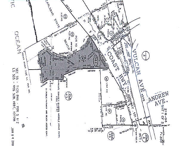
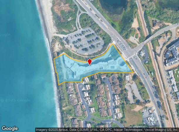
2100 N Coast Highway 101 Blvd
216-041-26
City/Encinitas
Hotel
PAR 1 (EX ST) TR PM18587
VE
San Diego
06073C1033H
California
2025
4.32 AC
2025
North Beach Cities
017701
San Diego
99,999 SF
San Diego-Carlsbad, CA
DEMOGRAPHICS near 2100 N Coast Highway 101 Blvd
1 Mile
3 Mile
5 Mile
2024 Total Population
6,485
49,537
133,395
2029 Population
6,541
49,383
132,598
Pop Growth 2024-2029
+ 0.86%
(0.31%)
(0.60%)
Average Age
43
44
43
2024 Total Households
2,836
20,058
51,891
HH Growth 2024-2029
+ 0.85%
(0.45%)
(0.71%)
Median Household Inc
$139,530
$138,589
$140,885
Avg Household Size
2.20
2.40
2.50
2024 Avg HH Vehicles
2.00
2.00
2.00
Median Home Value
$1,120,190
$1,080,828
$1,060,234
Median Year Built
1982
1987
1984
Nearby Places
Map Layers
Map Styles
 Street
 Aerial
- Restaurants
- Banks
- Shops
- Fitness
- Groceries
PUBLIC TRANSPORTATION
COMMUTER RAIL
Encinitas (Coaster - San Diego North County Transit District (Coaster/Sprinter/Breeze))
DRIVE
WALK
Distance
Encinitas (Coaster - San Diego North County Transit District (Coaster/Sprinter/Breeze))
7 min
3.0 mi
Carlsbad Poinsettia (Coaster - San Diego North County Transit District (Coaster/Sprinter/Breeze))
DRIVE
WALK
Distance
Carlsbad Poinsettia (Coaster - San Diego North County Transit District (Coaster/Sprinter/Breeze))
8 min
3.5 mi
AIRPORT
San Diego International
DRIVE
WALK
Distance
San Diego International
36 min
27.4 mi
Freight Ports
Port of San Diego
DRIVE
WALK
Distance
Port of San Diego
41 min
31.7 mi
Nearby Properties
Address
Land Use
TOTAL SIZE
Lot Size
Zoning
Address
Land Use
TOTAL SIZE
Lot Size
Zoning
55.06 AC
P-C
Address
Land Use
TOTAL SIZE
Lot Size
Zoning
18.19 AC
P-C
Address
Land Use
TOTAL SIZE
Lot Size
Zoning
30.88 AC
P-C
Address
Land Use
TOTAL SIZE
Lot Size
Zoning
12.62 AC
P-C
Address
Land Use
TOTAL SIZE
Lot Size
Zoning
21.15 AC
P-C
Address
Land Use
TOTAL SIZE
Lot Size
Zoning
18.34 AC
P-C
Address
Land Use
TOTAL SIZE
Lot Size
Zoning
12.44 AC
P/SP
Address
Land Use
TOTAL SIZE
Lot Size
Zoning
4.77 AC
ER-MU1
Address
Land Use
TOTAL SIZE
Lot Size
Zoning
5.45 AC
C-T
Address
Land Use
TOTAL SIZE
Lot Size
Zoning
14.73 AC
C-L
Address
Land Use
TOTAL SIZE
Lot Size
Zoning
91,431 SF
8.69 AC
C-2
Address
Land Use
TOTAL SIZE
Lot Size
Zoning
3.17 AC
C-T
Address
Land Use
TOTAL SIZE
Lot Size
Zoning
6.61 AC
P-C
Address
Land Use
TOTAL SIZE
Lot Size
Zoning
55,656 SF
13.04 AC
R-1-Q
Address
Land Use
TOTAL SIZE
Lot Size
Zoning
9.76 AC
M
Address
Land Use
TOTAL SIZE
Lot Size
Zoning
6.25 AC
P-C
Address
Land Use
TOTAL SIZE
Lot Size
Zoning
88,188 SF
1.95 AC
N-R3
Address
Land Use
TOTAL SIZE
Lot Size
Zoning
9.15 AC
RD-M-Q
Address
Land Use
TOTAL SIZE
Lot Size
Zoning
89,000 SF
8.61 AC
O
Address
Land Use
TOTAL SIZE
Lot Size
Zoning
71,962 SF
5.33 AC
P/SP
Address
Land Use
TOTAL SIZE
Lot Size
Zoning
50,039 SF
0.75 AC
O
Address
Land Use
TOTAL SIZE
Lot Size
Zoning
76,444 SF
4.59 AC
P-C
Address
Land Use
TOTAL SIZE
Lot Size
Zoning
5.91 AC
RD-M
Address
Land Use
TOTAL SIZE
Lot Size
Zoning
8,000 SF
9.20 AC
RD-M
Address
Land Use
TOTAL SIZE
Lot Size
Zoning
86,940 SF
3.85 AC
P-M
Address
Land Use
TOTAL SIZE
Lot Size
Zoning
4.78 AC
C-T-Q
Address
Land Use
TOTAL SIZE
Lot Size
Zoning
14.26 AC
P-C
Address
Land Use
TOTAL SIZE
Lot Size
Zoning
55,772 SF
4.54 AC
P-C
Address
Land Use
TOTAL SIZE
Lot Size
Zoning
5.58 AC
RD-M
The World's #1 Commercial Real Estate Marketplace
Connect with us
© 2025 CoStar Group
The information above has been obtained from sources believed reliable. While we do not doubt its accuracy we have not verified it and make no guarantee, warranty or representation about it. It is your responsibility to independently confirm its accuracy and completeness. Any projections, opinions, assumptions, or estimates used are for example only and do not represent the current or future performance of the property. The value of this transaction to you depends on tax and other factors which should be evaluated by your tax, financial, and legal advisors. You and your advisors should conduct a careful, independent investigation of the property to determine to your satisfaction the suitability of the property for your needs.