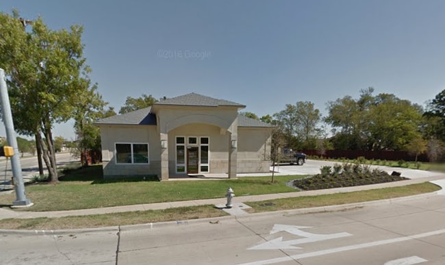
Property Record
2100 Ne Green Oaks Blvd, Arlington, TX 76006

NEARBY LISTINGS FOR SALE OR LEASE
Property Detail
2100 Ne Green Oaks Blvd
Dallas-Fort Worth-Arlington, TX
Coleman, Madison Survey
05981980
COLEMAN, MADISON SURVEY ABSTRACT 380 TRACT 1H
Residentialacreage
Tarrant
X
Texas
48439C0240L
0.06 AC
0
Arlington/Mansfield
2025
Dallas/Ft Worth
113116
DEMOGRAPHICS near 2100 Ne Green Oaks Blvd
1 Mile
3 Mile
5 Mile
2024 Total Population
19,114
84,840
251,563
2029 Population
20,030
89,474
263,872
Pop Growth 2024-2029
+ 4.79%
+ 5.46%
+ 4.89%
Average Age
35
36
35
2024 Total Households
9,224
38,972
98,144
HH Growth 2024-2029
+ 4.88%
+ 5.55%
+ 4.99%
Median Household Inc
$53,015
$55,972
$52,215
Avg Household Size
2.00
2.10
2.50
2024 Avg HH Vehicles
2.00
2.00
2.00
Median Home Value
$291,078
$302,616
$244,684
Median Year Built
1987
1986
1982
Nearby Places
Map Layers
Map Styles
 Street
 Aerial
- Restaurants
- Banks
- Shops
- Fitness
- Groceries
PUBLIC TRANSPORTATION
COMMUTER RAIL
Centre Port/DFW (Trinity Railway Express - Dallas Area Rapid Transit (DART))
DRIVE
WALK
Distance
Centre Port/DFW (Trinity Railway Express - Dallas Area Rapid Transit (DART))
9 min
4.5 mi
DRIVE
WALK
Distance
14 min
5.5 mi
AIRPORT
Dallas-Fort Worth International
DRIVE
WALK
Distance
Dallas-Fort Worth International
18 min
10.7 mi
Dallas Love Field
DRIVE
WALK
Distance
Dallas Love Field
29 min
19.5 mi
SALE & LEASE HISTORY
LISTING DATE
SALE/LEASE

Jun 03, 2023
For Sale
Apr 13, 2017
For Sale
Nearby Properties
Address
Land Use
TOTAL SIZE
Lot Size
Zoning
Address
Land Use
TOTAL SIZE
Lot Size
Zoning
1,700,000 SF
8.23 AC
Address
Land Use
TOTAL SIZE
Lot Size
Zoning
3,015,800 SF
72.86 AC
Address
Land Use
TOTAL SIZE
Lot Size
Zoning
1,400,000 SF
15.30 AC
Address
Land Use
TOTAL SIZE
Lot Size
Zoning
269,257 SF
21.33 AC
Address
Land Use
TOTAL SIZE
Lot Size
Zoning
378,182 SF
5.02 AC
Address
Land Use
TOTAL SIZE
Lot Size
Zoning
287,560 SF
3.28 AC
Address
Land Use
TOTAL SIZE
Lot Size
Zoning
5,995,915 SF
248.78 AC
Address
Land Use
TOTAL SIZE
Lot Size
Zoning
458,819 SF
15.88 AC
Address
Land Use
TOTAL SIZE
Lot Size
Zoning
485,911 SF
54.76 AC
Address
Land Use
TOTAL SIZE
Lot Size
Zoning
521,200 SF
7.99 AC
Address
Land Use
TOTAL SIZE
Lot Size
Zoning
548,095 SF
7.19 AC
Address
Land Use
TOTAL SIZE
Lot Size
Zoning
522,294 SF
18.35 AC
Address
Land Use
TOTAL SIZE
Lot Size
Zoning
578,395 SF
6.22 AC
Address
Land Use
TOTAL SIZE
Lot Size
Zoning
548,806 SF
5.56 AC
Address
Land Use
TOTAL SIZE
Lot Size
Zoning
1,261,810 SF
80.53 AC
Address
Land Use
TOTAL SIZE
Lot Size
Zoning
324,303 SF
23.15 AC
Address
Land Use
TOTAL SIZE
Lot Size
Zoning
450,535 SF
27.23 AC
Address
Land Use
TOTAL SIZE
Lot Size
Zoning
139,821 SF
Address
Land Use
TOTAL SIZE
Lot Size
Zoning
342,583 SF
23.87 AC
Address
Land Use
TOTAL SIZE
Lot Size
Zoning
339,965 SF
15.59 AC
Address
Land Use
TOTAL SIZE
Lot Size
Zoning
576,000 SF
55.36 AC
Z123
Address
Land Use
TOTAL SIZE
Lot Size
Zoning
539,000 SF
3.91 AC
Address
Land Use
TOTAL SIZE
Lot Size
Zoning
300,915 SF
24.90 AC
Address
Land Use
TOTAL SIZE
Lot Size
Zoning
285,194 SF
15.91 AC
Address
Land Use
TOTAL SIZE
Lot Size
Zoning
313,349 SF
15.39 AC
Address
Land Use
TOTAL SIZE
Lot Size
Zoning
345,216 SF
21.64 AC
Address
Land Use
TOTAL SIZE
Lot Size
Zoning
137,878 SF
189.88 AC
Address
Land Use
TOTAL SIZE
Lot Size
Zoning
334,660 SF
17.59 AC
Address
Land Use
TOTAL SIZE
Lot Size
Zoning
253,710 SF
11.50 AC
Address
Land Use
TOTAL SIZE
Lot Size
Zoning
267,684 SF
11.01 AC
The World's #1 Commercial Real Estate Marketplace
Connect with us
© 2026 CoStar Group
The information above has been obtained from sources believed reliable. While we do not doubt its accuracy we have not verified it and make no guarantee, warranty or representation about it. It is your responsibility to independently confirm its accuracy and completeness. Any projections, opinions, assumptions, or estimates used are for example only and do not represent the current or future performance of the property. The value of this transaction to you depends on tax and other factors which should be evaluated by your tax, financial, and legal advisors. You and your advisors should conduct a careful, independent investigation of the property to determine to your satisfaction the suitability of the property for your needs.