No Photo
Property Record
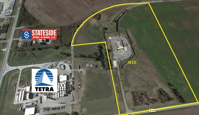
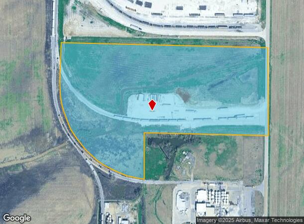
1901 Port Rd, West Memphis, AR 72301
NEARBY LISTINGS FOR SALE OR LEASE
Property Detail
1901 Port Rd
104-125300-000
Rural 25-06-08
Lightindustrial
TRACT IN W1/2 E1/2
X
Crittenden
05035C0450E
Arkansas
2025
20 AC
2025
Crittenden County
030602
Memphis
2,714 SF
Memphis, TN-MS-AR
DEMOGRAPHICS near 1901 Port Rd
1 Mile
3 Mile
5 Mile
2024 Total Population
0
10,163
25,089
2029 Population
0
9,922
24,529
Pop Growth 2024-2029
0.00%
(2.37%)
(2.23%)
Average Age
0
39
38
2024 Total Households
0
4,160
10,018
HH Growth 2024-2029
0.00%
(2.43%)
(2.28%)
Median Household Inc
$0
$32,121
$34,923
Avg Household Size
.00
2.30
2.40
2024 Avg HH Vehicles
.00
1.00
1.00
Median Home Value
$0
$92,200
$103,618
Median Year Built
0
1983
1976
Nearby Places
Map Layers
Map Styles
 Street
 Aerial
- Restaurants
- Banks
- Shops
- Fitness
- Groceries
PUBLIC TRANSPORTATION
COMMUTER RAIL
Central Station (Riverfront Loop - Memphis Area Transit Authority Trolley (MataTrolley))
DRIVE
WALK
Distance
Central Station (Riverfront Loop - Memphis Area Transit Authority Trolley (MataTrolley))
16 min
9.7 mi
AIRPORT
Memphis International
DRIVE
WALK
Distance
Memphis International
29 min
18.9 mi
Freight Ports
Port of Shreveport
DRIVE
WALK
Distance
Port of Shreveport
395 min
362.0 mi
SALE & LEASE HISTORY
LISTING DATE
SALE/LEASE

Sep 23, 2016
For Sale
Mar 20, 2017
For Sale
Nearby Properties
Address
Land Use
TOTAL SIZE
Lot Size
Zoning
Address
Land Use
TOTAL SIZE
Lot Size
Zoning
69,600 SF
38.09 AC
Address
Land Use
TOTAL SIZE
Lot Size
Zoning
665,000 SF
46.40 AC
Address
Land Use
TOTAL SIZE
Lot Size
Zoning
131,846 SF
27.83 AC
Address
Land Use
TOTAL SIZE
Lot Size
Zoning
328,229 SF
20 AC
Address
Land Use
TOTAL SIZE
Lot Size
Zoning
12,088 SF
98.07 AC
Address
Land Use
TOTAL SIZE
Lot Size
Zoning
2,728 SF
10.54 AC
Address
Land Use
TOTAL SIZE
Lot Size
Zoning
23,900 SF
11.23 AC
Address
Land Use
TOTAL SIZE
Lot Size
Zoning
7,056 SF
7.63 AC
Address
Land Use
TOTAL SIZE
Lot Size
Zoning
35,796 SF
1.75 AC
Address
Land Use
TOTAL SIZE
Lot Size
Zoning
64,000 SF
54.34 AC
Address
Land Use
TOTAL SIZE
Lot Size
Zoning
3,108 SF
6.94 AC
Address
Land Use
TOTAL SIZE
Lot Size
Zoning
84,830 SF
19.30 AC
Address
Land Use
TOTAL SIZE
Lot Size
Zoning
16,506 SF
4.30 AC
Address
Land Use
TOTAL SIZE
Lot Size
Zoning
5,598 SF
20.36 AC
Address
Land Use
TOTAL SIZE
Lot Size
Zoning
16,664 SF
5.54 AC
Address
Land Use
TOTAL SIZE
Lot Size
Zoning
3,693 SF
7.38 AC
Address
Land Use
TOTAL SIZE
Lot Size
Zoning
2,592 SF
5 AC
Address
Land Use
TOTAL SIZE
Lot Size
Zoning
4,800 SF
Address
Land Use
TOTAL SIZE
Lot Size
Zoning
3,540 SF
7.80 AC
Address
Land Use
TOTAL SIZE
Lot Size
Zoning
46,510 SF
5.56 AC
Address
Land Use
TOTAL SIZE
Lot Size
Zoning
30,756 SF
1.95 AC
Address
Land Use
TOTAL SIZE
Lot Size
Zoning
3,012 SF
70.77 AC
Address
Land Use
TOTAL SIZE
Lot Size
Zoning
21,720 SF
2.40 AC
Address
Land Use
TOTAL SIZE
Lot Size
Zoning
11,310 SF
4.07 AC
Address
Land Use
TOTAL SIZE
Lot Size
Zoning
7,649 SF
7.02 AC
Address
Land Use
TOTAL SIZE
Lot Size
Zoning
3,720 SF
6.02 AC
Address
Land Use
TOTAL SIZE
Lot Size
Zoning
7,000 SF
3.85 AC
Address
Land Use
TOTAL SIZE
Lot Size
Zoning
36,119 SF
2.95 AC
Address
Land Use
TOTAL SIZE
Lot Size
Zoning
2,526 SF
8.39 AC
Address
Land Use
TOTAL SIZE
Lot Size
Zoning
10,011 SF
1.61 AC
The World's #1 Commercial Real Estate Marketplace
Connect with us
© 2025 CoStar Group
The information above has been obtained from sources believed reliable. While we do not doubt its accuracy we have not verified it and make no guarantee, warranty or representation about it. It is your responsibility to independently confirm its accuracy and completeness. Any projections, opinions, assumptions, or estimates used are for example only and do not represent the current or future performance of the property. The value of this transaction to you depends on tax and other factors which should be evaluated by your tax, financial, and legal advisors. You and your advisors should conduct a careful, independent investigation of the property to determine to your satisfaction the suitability of the property for your needs.