Property Record
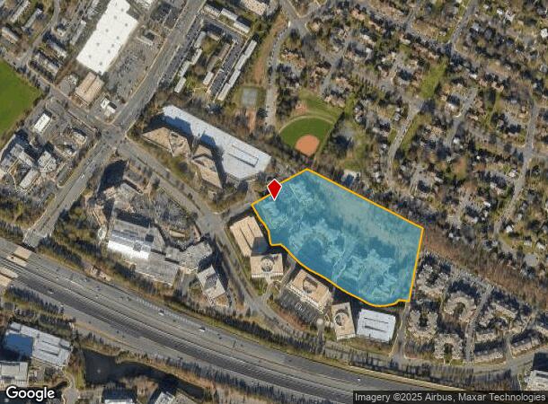
2100 Raven Tower Ct, Herndon, VA 20170

NEARBY LISTINGS FOR SALE OR LEASE
Property Detail
2100 Raven Tower Ct
Washington-Arlington-Alexandria, DC-VA-MD-WV
Near Herndon
0163-02-0002B
NEAR HERNDON
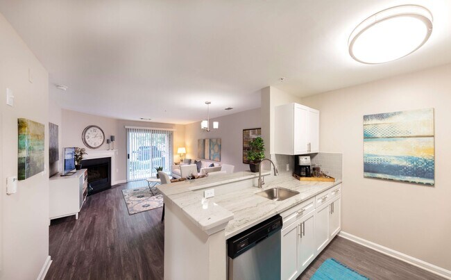
Apartment
Fairfax
X
Virginia
51107C0385E
2b
2024
14.77 AC
2025
Herndon
480903
Washington, DC
328,008 SF
DEMOGRAPHICS near 2100 Raven Tower Ct
1 Mile
3 Mile
5 Mile
2024 Total Population
26,983
127,051
220,324
2029 Population
26,678
126,921
221,364
Pop Growth 2024-2029
(1.13%)
(0.10%)
+ 0.47%
Average Age
35
38
39
2024 Total Households
9,585
47,865
80,851
HH Growth 2024-2029
(0.71%)
0.00%
+ 0.41%
Median Household Inc
$113,579
$130,725
$138,661
Avg Household Size
2.70
2.60
2.70
2024 Avg HH Vehicles
2.00
2.00
2.00
Median Home Value
$488,960
$610,616
$643,910
Median Year Built
1993
1989
1987
Nearby Places
- Restaurants
- Banks
- Shops
- Fitness
- Groceries
PUBLIC TRANSPORTATION
AIRPORT
Washington Dulles International
DRIVE
WALK
Distance
Washington Dulles International
12 min
4.2 mi
Ronald Reagan Washington Ntl
DRIVE
WALK
Distance
Ronald Reagan Washington Ntl
40 min
26.3 mi
Freight Ports
Port of Baltimore
DRIVE
WALK
Distance
Port of Baltimore
80 min
58.3 mi
Nearby Properties
Address
Land Use
TOTAL SIZE
Lot Size
Zoning
Address
Land Use
TOTAL SIZE
Lot Size
Zoning
1,030,157 SF
47.95 AC
550
Address
Land Use
TOTAL SIZE
Lot Size
Zoning
1,071,881 SF
373
Address
Land Use
TOTAL SIZE
Lot Size
Zoning
147,260 SF
33.04 AC
PDIP
Address
Land Use
TOTAL SIZE
Lot Size
Zoning
764,166 SF
73.90 AC
PDIP
Address
Land Use
TOTAL SIZE
Lot Size
Zoning
643,232 SF
2.81 AC
373
Address
Land Use
TOTAL SIZE
Lot Size
Zoning
473,458 SF
13.74 AC
540
Address
Land Use
TOTAL SIZE
Lot Size
Zoning
226,456 SF
17.09 AC
PDIP
Address
Land Use
TOTAL SIZE
Lot Size
Zoning
1,096,572 SF
85.06 AC
110
Address
Land Use
TOTAL SIZE
Lot Size
Zoning
446,810 SF
1.12 AC
373
Address
Land Use
TOTAL SIZE
Lot Size
Zoning
120,240 SF
12.15 AC
PDIP
Address
Land Use
TOTAL SIZE
Lot Size
Zoning
450,397 SF
1.07 AC
373
Address
Land Use
TOTAL SIZE
Lot Size
Zoning
128,500 SF
9.95 AC
PDIP
Address
Land Use
TOTAL SIZE
Lot Size
Zoning
275,809 SF
0.75 AC
373
Address
Land Use
TOTAL SIZE
Lot Size
Zoning
332,957 SF
12.68 AC
550
Address
Land Use
TOTAL SIZE
Lot Size
Zoning
532,480 SF
4.62 AC
373
Address
Land Use
TOTAL SIZE
Lot Size
Zoning
425,073 SF
19.02 AC
330
Address
Land Use
TOTAL SIZE
Lot Size
Zoning
469,276 SF
11.42 AC
373
Address
Land Use
TOTAL SIZE
Lot Size
Zoning
560,356 SF
4.33 AC
372
Address
Land Use
TOTAL SIZE
Lot Size
Zoning
357,437 SF
3.76 AC
350
Address
Land Use
TOTAL SIZE
Lot Size
Zoning
407,812 SF
33.12 AC
373
Address
Land Use
TOTAL SIZE
Lot Size
Zoning
429,038 SF
11.41 AC
400
Address
Land Use
TOTAL SIZE
Lot Size
Zoning
337,921 SF
13.57 AC
373
Address
Land Use
TOTAL SIZE
Lot Size
Zoning
437,235 SF
3.33 AC
373
Address
Land Use
TOTAL SIZE
Lot Size
Zoning
396,112 SF
15.92 AC
330
Address
Land Use
TOTAL SIZE
Lot Size
Zoning
490,340 SF
18.30 AC
320
Address
Land Use
TOTAL SIZE
Lot Size
Zoning
491,841 SF
19.21 AC
320
Address
Land Use
TOTAL SIZE
Lot Size
Zoning
325,000 SF
22.05 AC
550
Address
Land Use
TOTAL SIZE
Lot Size
Zoning
519,708 SF
18.73 AC
316
Address
Land Use
TOTAL SIZE
Lot Size
Zoning
263,767 SF
2.34 AC
373
Address
Land Use
TOTAL SIZE
Lot Size
Zoning
408,315 SF
5.06 AC
400
The World's #1 Commercial Real Estate Marketplace
Connect with us
© 2025 CoStar Group
The information above has been obtained from sources believed reliable. While we do not doubt its accuracy we have not verified it and make no guarantee, warranty or representation about it. It is your responsibility to independently confirm its accuracy and completeness. Any projections, opinions, assumptions, or estimates used are for example only and do not represent the current or future performance of the property. The value of this transaction to you depends on tax and other factors which should be evaluated by your tax, financial, and legal advisors. You and your advisors should conduct a careful, independent investigation of the property to determine to your satisfaction the suitability of the property for your needs.