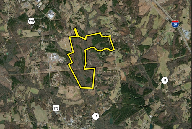
Property Record
Hulon Howard Rd, Landrum, SC 29356
Property Detail
Hulon Howard Rd
Spartanburg, SC
E SIDE SOUTHERN RR & S OF HULON HOWARD RD PB 125-428 DB 119T-638 DB 133Z-526
1-14-00-125.09
SPARTANBURG
Taxexempt
South Carolina
B and X Area of moderate flood hazard, usually the area between the limits of the 100-year and 500-year floods.
51.65 AC
2024
Upper Spartanburg County
2025
Greenville/Spartanburg
002404
NEARBY LISTINGS FOR SALE OR LEASE
-
-
View all Landrum listings for sale on LoopNet.com
DEMOGRAPHICS near Hulon Howard Rd
1 mile
3 mile
5 mile
2025 Total Population
529
6,410
16,336
2030 Population
592
7,176
18,292
Pop Growth 2025-2030
+ 11.91%
+ 11.95%
+ 11.97%
Average Age
44
43
43
2025 Total Households
204
2,639
6,523
HH Growth 2025-2030
+ 12.25%
+ 12.01%
+ 12.02%
Median Household Inc
$69,999
$52,731
$62,413
Avg Household Size
2.50
2.40
2.50
2025 Avg HH Vehicles
2.00
2.00
2.00
Median Home Value
$367,241
$286,894
$290,963
Median Year Built
1989
1982
1988
Nearby Places
Map Layers
Map Styles
 Street
 Aerial
Layers
 Traffic
 Biking
Places
Listings with unknown addresses are not visible on the map
- Restaurants
- Banks
- Shops
- Fitness
- Groceries
PUBLIC TRANSPORTATION
AIRPORT
Greenville Spartanburg International
Drive
Walk
Distance
Greenville Spartanburg International
46 min
25.1 mi
Asheville Regional
Drive
Walk
Distance
Asheville Regional
51 min
37.4 mi
Freight Ports
North Charleston Terminal
Drive
Walk
Distance
North Charleston Terminal
242 min
213.7 mi
SALE & LEASE HISTORY
LISTING DATE
SALE/LEASE

Nov 22, 2022
For Sale
Nearby Properties
Address
Land Use
TOTAL SIZE
Lot Size
Zoning
Address
Land Use
TOTAL SIZE
Lot Size
Zoning
332.64 AC
Address
Land Use
TOTAL SIZE
Lot Size
Zoning
13,225 SF
14.20 AC
Address
Land Use
TOTAL SIZE
Lot Size
Zoning
20.67 AC
Address
Land Use
TOTAL SIZE
Lot Size
Zoning
114,986 SF
29.83 AC
Address
Land Use
TOTAL SIZE
Lot Size
Zoning
18.62 AC
Address
Land Use
TOTAL SIZE
Lot Size
Zoning
4,402 SF
5.65 AC
Address
Land Use
TOTAL SIZE
Lot Size
Zoning
13,661 SF
2 AC
Address
Land Use
TOTAL SIZE
Lot Size
Zoning
98,780 SF
40.19 AC
Address
Land Use
TOTAL SIZE
Lot Size
Zoning
2,754 SF
0.16 AC
Address
Land Use
TOTAL SIZE
Lot Size
Zoning
2,376 SF
9.40 AC
Address
Land Use
TOTAL SIZE
Lot Size
Zoning
1,820 SF
0.45 AC
Address
Land Use
TOTAL SIZE
Lot Size
Zoning
2,832 SF
14.36 AC
Address
Land Use
TOTAL SIZE
Lot Size
Zoning
2,792 SF
0.27 AC
Address
Land Use
TOTAL SIZE
Lot Size
Zoning
2,079 SF
4.11 AC
Address
Land Use
TOTAL SIZE
Lot Size
Zoning
18,336 SF
6.90 AC
Address
Land Use
TOTAL SIZE
Lot Size
Zoning
2,086 SF
0.54 AC
Address
Land Use
TOTAL SIZE
Lot Size
Zoning
4,080 SF
2.40 AC
Address
Land Use
TOTAL SIZE
Lot Size
Zoning
1,880 SF
0.19 AC
Address
Land Use
TOTAL SIZE
Lot Size
Zoning
2,608 SF
1.08 AC
Address
Land Use
TOTAL SIZE
Lot Size
Zoning
10,528 SF
2.07 AC
Address
Land Use
TOTAL SIZE
Lot Size
Zoning
1,590 SF
0.50 AC
Address
Land Use
TOTAL SIZE
Lot Size
Zoning
2,164 SF
0.34 AC
Address
Land Use
TOTAL SIZE
Lot Size
Zoning
3,964 SF
1.40 AC
Address
Land Use
TOTAL SIZE
Lot Size
Zoning
2,045 SF
0.46 AC
Address
Land Use
TOTAL SIZE
Lot Size
Zoning
2,522 SF
12.13 AC
Address
Land Use
TOTAL SIZE
Lot Size
Zoning
4,228 SF
0.76 AC
Address
Land Use
TOTAL SIZE
Lot Size
Zoning
3,200 SF
2.89 AC
Address
Land Use
TOTAL SIZE
Lot Size
Zoning
95,006 SF
9.06 AC
Address
Land Use
TOTAL SIZE
Lot Size
Zoning
4,810 SF
1.45 AC
The World's #1 Commercial Real Estate Marketplace
Connect with us
© 2026 CoStar Group
The information above has been obtained from sources believed reliable. While we do not doubt its accuracy we have not verified it and make no guarantee, warranty or representation about it. It is your responsibility to independently confirm its accuracy and completeness. Any projections, opinions, assumptions, or estimates used are for example only and do not represent the current or future performance of the property. The value of this transaction to you depends on tax and other factors which should be evaluated by your tax, financial, and legal advisors. You and your advisors should conduct a careful, independent investigation of the property to determine to your satisfaction the suitability of the property for your needs.