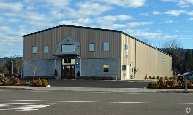
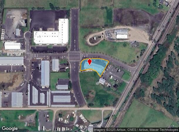
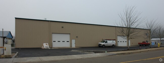
Property Record
2100 S R Rd, Cottage Grove, OR 97424
NEARBY LISTINGS FOR SALE OR LEASE
Property Detail
2100 S R Rd
Eugene, OR
2007-P2125
1804416
PARTITION PLAT 2007-P2125 PCL 3 TL 00703
Industrialgeneral
Lane
X
Oregon
41039C2090F
703
2025
0.65 AC
2025
Lane County
001202
Portland
DEMOGRAPHICS near 2100 S R Rd
1 Mile
3 Mile
5 Mile
2024 Total Population
4,814
14,342
16,464
2029 Population
4,821
14,359
16,462
Pop Growth 2024-2029
+ 0.15%
+ 0.12%
(0.01%)
Average Age
41
42
43
2024 Total Households
1,824
5,555
6,388
HH Growth 2024-2029
+ 0.16%
+ 0.07%
(0.06%)
Median Household Inc
$56,631
$57,283
$57,993
Avg Household Size
2.60
2.50
2.50
2024 Avg HH Vehicles
2.00
2.00
2.00
Median Home Value
$316,304
$323,618
$336,929
Median Year Built
1971
1973
1974
Nearby Places
Map Layers
Map Styles
 Street
 Aerial
- Restaurants
- Banks
- Shops
- Fitness
- Groceries
PUBLIC TRANSPORTATION
AIRPORT
Mahlon Sweet Field
DRIVE
WALK
Distance
Mahlon Sweet Field
49 min
33.3 mi
Freight Ports
Port of Coos Bay, OR
DRIVE
WALK
Distance
Port of Coos Bay, OR
139 min
93.2 mi
Nearby Properties
Address
Land Use
TOTAL SIZE
Lot Size
Zoning
Address
Land Use
TOTAL SIZE
Lot Size
Zoning
166.25 AC
RI
Address
Land Use
TOTAL SIZE
Lot Size
Zoning
110.14 AC
CA
Address
Land Use
TOTAL SIZE
Lot Size
Zoning
1,440 SF
164.70 AC
RI
Address
Land Use
TOTAL SIZE
Lot Size
Zoning
6.07 AC
AGT5
Address
Land Use
TOTAL SIZE
Lot Size
Zoning
4.15 AC
M
Address
Land Use
TOTAL SIZE
Lot Size
Zoning
12.30 AC
C2P
Address
Land Use
TOTAL SIZE
Lot Size
Zoning
21.15 AC
R1
Address
Land Use
TOTAL SIZE
Lot Size
Zoning
32.71 AC
R1
Address
Land Use
TOTAL SIZE
Lot Size
Zoning
20.56 AC
R1
Address
Land Use
TOTAL SIZE
Lot Size
Zoning
3.91 AC
C2P
Address
Land Use
TOTAL SIZE
Lot Size
Zoning
10.22 AC
M
Address
Land Use
TOTAL SIZE
Lot Size
Zoning
4.47 AC
C2P
Address
Land Use
TOTAL SIZE
Lot Size
Zoning
10.06 AC
CA
Address
Land Use
TOTAL SIZE
Lot Size
Zoning
4.09 AC
CT/L
Address
Land Use
TOTAL SIZE
Lot Size
Zoning
3.45 AC
R1
Address
Land Use
TOTAL SIZE
Lot Size
Zoning
39.52 AC
PR
Address
Land Use
TOTAL SIZE
Lot Size
Zoning
6.75 AC
C2P
Address
Land Use
TOTAL SIZE
Lot Size
Zoning
1.85 AC
C2P
Address
Land Use
TOTAL SIZE
Lot Size
Zoning
1.57 AC
R1
Address
Land Use
TOTAL SIZE
Lot Size
Zoning
7 AC
C2P
Address
Land Use
TOTAL SIZE
Lot Size
Zoning
1.54 AC
R1
Address
Land Use
TOTAL SIZE
Lot Size
Zoning
2.96 AC
R1
Address
Land Use
TOTAL SIZE
Lot Size
Zoning
3.36 AC
R1
Address
Land Use
TOTAL SIZE
Lot Size
Zoning
10.51 AC
C2P
Address
Land Use
TOTAL SIZE
Lot Size
Zoning
3.02 AC
M
Address
Land Use
TOTAL SIZE
Lot Size
Zoning
0.93 AC
CT
Address
Land Use
TOTAL SIZE
Lot Size
Zoning
1.52 AC
CT
Address
Land Use
TOTAL SIZE
Lot Size
Zoning
10.56 AC
CA
Address
Land Use
TOTAL SIZE
Lot Size
Zoning
1.41 AC
R1
Address
Land Use
TOTAL SIZE
Lot Size
Zoning
3.80 AC
M
The World's #1 Commercial Real Estate Marketplace
Connect with us
© 2025 CoStar Group
The information above has been obtained from sources believed reliable. While we do not doubt its accuracy we have not verified it and make no guarantee, warranty or representation about it. It is your responsibility to independently confirm its accuracy and completeness. Any projections, opinions, assumptions, or estimates used are for example only and do not represent the current or future performance of the property. The value of this transaction to you depends on tax and other factors which should be evaluated by your tax, financial, and legal advisors. You and your advisors should conduct a careful, independent investigation of the property to determine to your satisfaction the suitability of the property for your needs.