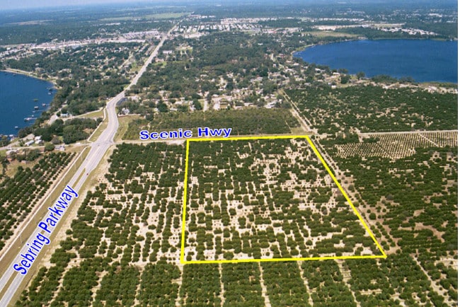
Property Record
2100 Scenic Hwy, Sebring, FL 33870

NEARBY LISTINGS FOR SALE OR LEASE
-
-
No Photo
-
-
-
-
-
-
View all Sebring listings for sale on LoopNet.com
Property Detail
2100 Scenic Hwy
Sebring, FL
Lake Shore Park Sub
C-13-34-28-100-0110-0000
LAKE SHORE PARK PB 1 PG 1 TRACT 11 - LESS RD R/W
Warehouse
Highlands
X
Florida
12055C0138C
11
0
33.52 AC
2025
Florida Central South Area
960700
Other Market Areas
104,876 SF
DEMOGRAPHICS near 2100 Scenic Hwy
1 Mile
3 Mile
5 Mile
2024 Total Population
2,247
26,986
49,980
2029 Population
2,450
29,392
54,550
Pop Growth 2024-2029
+ 9.03%
+ 8.92%
+ 9.14%
Average Age
47
51
50
2024 Total Households
976
12,326
22,528
HH Growth 2024-2029
+ 9.22%
+ 9.11%
+ 9.30%
Median Household Inc
$55,051
$51,392
$49,834
Avg Household Size
2.30
2.10
2.10
2024 Avg HH Vehicles
2.00
1.00
1.00
Median Home Value
$160,833
$129,490
$149,556
Median Year Built
1982
1985
1985
Nearby Places
Map Layers
Map Styles
 Street
 Aerial
- Restaurants
- Banks
- Shops
- Fitness
- Groceries
PUBLIC TRANSPORTATION
COMMUTER RAIL
Sebring Amtrak Station (Silver Meteor - Amtrak, Silver Star - Amtrak)
DRIVE
WALK
Distance
Sebring Amtrak Station (Silver Meteor - Amtrak, Silver Star - Amtrak)
6 min
3.3 mi
Freight Ports
Port of Tampa Bay
DRIVE
WALK
Distance
Port of Tampa Bay
120 min
86.1 mi
Nearby Properties
Address
Land Use
TOTAL SIZE
Lot Size
Zoning
Address
Land Use
TOTAL SIZE
Lot Size
Zoning
319,284 SF
76.37 AC
P
Address
Land Use
TOTAL SIZE
Lot Size
Zoning
235,165 SF
33.99 AC
B3
Address
Land Use
TOTAL SIZE
Lot Size
Zoning
114,905 SF
3.34 AC
PU
Address
Land Use
TOTAL SIZE
Lot Size
Zoning
155,486 SF
21.71 AC
C1
Address
Land Use
TOTAL SIZE
Lot Size
Zoning
91,734 SF
2.23 AC
R3
Address
Land Use
TOTAL SIZE
Lot Size
Zoning
118,053 SF
21.01 AC
P
Address
Land Use
TOTAL SIZE
Lot Size
Zoning
114,960 SF
6.68 AC
PU
Address
Land Use
TOTAL SIZE
Lot Size
Zoning
116,629 SF
19.72 AC
EU
Address
Land Use
TOTAL SIZE
Lot Size
Zoning
176,175 SF
22.73 AC
C1
Address
Land Use
TOTAL SIZE
Lot Size
Zoning
62,304 SF
6.18 AC
B3
Address
Land Use
TOTAL SIZE
Lot Size
Zoning
320 SF
10.93 AC
C1
Address
Land Use
TOTAL SIZE
Lot Size
Zoning
23,187 SF
0.68 AC
P
Address
Land Use
TOTAL SIZE
Lot Size
Zoning
137,240 SF
14.46 AC
B3
Address
Land Use
TOTAL SIZE
Lot Size
Zoning
78,361 SF
3.12 AC
PU
Address
Land Use
TOTAL SIZE
Lot Size
Zoning
119,540 SF
15.17 AC
B3
Address
Land Use
TOTAL SIZE
Lot Size
Zoning
57,978 SF
3.80 AC
MUQD
Address
Land Use
TOTAL SIZE
Lot Size
Zoning
73,229 SF
14.19 AC
PU
Address
Land Use
TOTAL SIZE
Lot Size
Zoning
64,124 SF
4.16 AC
PU
Address
Land Use
TOTAL SIZE
Lot Size
Zoning
71,609 SF
15.32 AC
P
Address
Land Use
TOTAL SIZE
Lot Size
Zoning
46,625 SF
6.45 AC
R3FUD
Address
Land Use
TOTAL SIZE
Lot Size
Zoning
55,072 SF
5.16 AC
MUQD
Address
Land Use
TOTAL SIZE
Lot Size
Zoning
39,144 SF
1.67 AC
C1
Address
Land Use
TOTAL SIZE
Lot Size
Zoning
102,610 SF
5.06 AC
C1
Address
Land Use
TOTAL SIZE
Lot Size
Zoning
31,806 SF
6 AC
R3
Address
Land Use
TOTAL SIZE
Lot Size
Zoning
55,344 SF
8.15 AC
C1
Address
Land Use
TOTAL SIZE
Lot Size
Zoning
388,414 SF
49.99 AC
B4FUD
Address
Land Use
TOTAL SIZE
Lot Size
Zoning
53,846 SF
2.03 AC
C1
Address
Land Use
TOTAL SIZE
Lot Size
Zoning
26,587 SF
1.80 AC
B3
Address
Land Use
TOTAL SIZE
Lot Size
Zoning
3,111 SF
18.55 AC
CG3
The World's #1 Commercial Real Estate Marketplace
Connect with us
© 2026 CoStar Group
The information above has been obtained from sources believed reliable. While we do not doubt its accuracy we have not verified it and make no guarantee, warranty or representation about it. It is your responsibility to independently confirm its accuracy and completeness. Any projections, opinions, assumptions, or estimates used are for example only and do not represent the current or future performance of the property. The value of this transaction to you depends on tax and other factors which should be evaluated by your tax, financial, and legal advisors. You and your advisors should conduct a careful, independent investigation of the property to determine to your satisfaction the suitability of the property for your needs.