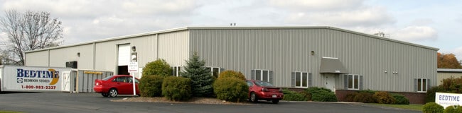
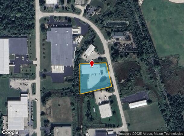
Property Record
2100 Stonebridge Cir, West Bend, WI 53095
NEARBY LISTINGS FOR SALE OR LEASE
Property Detail
2100 Stonebridge Cir
Milwaukee-Waukesha-West Allis, WI
Certified Survey Map No 4120
1119-251-0013
PARCEL 2 CSM 4120 DOC 1524807
Industrialgeneral
Washington
X
Wisconsin
55131C0168D
1.62 AC
2024
North Washington
2024
Milwaukee/Madison
420107
DEMOGRAPHICS near 2100 Stonebridge Cir
1 Mile
3 Mile
5 Mile
2024 Total Population
4,912
26,900
47,810
2029 Population
5,030
27,577
48,906
Pop Growth 2024-2029
+ 2.40%
+ 2.52%
+ 2.29%
Average Age
41
42
43
2024 Total Households
2,136
11,607
20,413
HH Growth 2024-2029
+ 2.39%
+ 2.62%
+ 2.35%
Median Household Inc
$66,956
$69,413
$73,245
Avg Household Size
2.30
2.20
2.30
2024 Avg HH Vehicles
2.00
2.00
2.00
Median Home Value
$244,636
$235,867
$254,437
Median Year Built
1985
1975
1979
Nearby Places
Map Layers
Map Styles
 Street
 Aerial
- Restaurants
- Banks
- Shops
- Fitness
- Groceries
Nearby Properties
Address
Land Use
TOTAL SIZE
Lot Size
Zoning
Address
Land Use
TOTAL SIZE
Lot Size
Zoning
141,874 SF
116.53 AC
Address
Land Use
TOTAL SIZE
Lot Size
Zoning
5,600 SF
10.11 AC
Address
Land Use
TOTAL SIZE
Lot Size
Zoning
195,055 SF
20.57 AC
Address
Land Use
TOTAL SIZE
Lot Size
Zoning
2.98 AC
Address
Land Use
TOTAL SIZE
Lot Size
Zoning
Address
Land Use
TOTAL SIZE
Lot Size
Zoning
141,575 SF
4.44 AC
Address
Land Use
TOTAL SIZE
Lot Size
Zoning
4,140 SF
29.62 AC
Address
Land Use
TOTAL SIZE
Lot Size
Zoning
20.92 AC
Address
Land Use
TOTAL SIZE
Lot Size
Zoning
9.05 AC
Address
Land Use
TOTAL SIZE
Lot Size
Zoning
139,945 SF
4.95 AC
Address
Land Use
TOTAL SIZE
Lot Size
Zoning
18.22 AC
Address
Land Use
TOTAL SIZE
Lot Size
Zoning
46.95 AC
Address
Land Use
TOTAL SIZE
Lot Size
Zoning
200,000 SF
16.18 AC
Address
Land Use
TOTAL SIZE
Lot Size
Zoning
30,564 SF
31.65 AC
Address
Land Use
TOTAL SIZE
Lot Size
Zoning
102,366 SF
9.35 AC
Address
Land Use
TOTAL SIZE
Lot Size
Zoning
50,096 SF
8.91 AC
Address
Land Use
TOTAL SIZE
Lot Size
Zoning
26.21 AC
Address
Land Use
TOTAL SIZE
Lot Size
Zoning
30,046 SF
3.91 AC
Address
Land Use
TOTAL SIZE
Lot Size
Zoning
80,634 SF
22.21 AC
Address
Land Use
TOTAL SIZE
Lot Size
Zoning
7.70 AC
Address
Land Use
TOTAL SIZE
Lot Size
Zoning
18,400 SF
10.85 AC
Address
Land Use
TOTAL SIZE
Lot Size
Zoning
65,350 SF
5.92 AC
Address
Land Use
TOTAL SIZE
Lot Size
Zoning
8.29 AC
Address
Land Use
TOTAL SIZE
Lot Size
Zoning
12.67 AC
Address
Land Use
TOTAL SIZE
Lot Size
Zoning
Address
Land Use
TOTAL SIZE
Lot Size
Zoning
27,400 SF
1.83 AC
Address
Land Use
TOTAL SIZE
Lot Size
Zoning
78,372 SF
1.49 AC
Address
Land Use
TOTAL SIZE
Lot Size
Zoning
66,378 SF
10.06 AC
Address
Land Use
TOTAL SIZE
Lot Size
Zoning
56,204 SF
2.29 AC
Address
Land Use
TOTAL SIZE
Lot Size
Zoning
11,964 SF
4.74 AC
The World's #1 Commercial Real Estate Marketplace
Connect with us
© 2025 CoStar Group
The information above has been obtained from sources believed reliable. While we do not doubt its accuracy we have not verified it and make no guarantee, warranty or representation about it. It is your responsibility to independently confirm its accuracy and completeness. Any projections, opinions, assumptions, or estimates used are for example only and do not represent the current or future performance of the property. The value of this transaction to you depends on tax and other factors which should be evaluated by your tax, financial, and legal advisors. You and your advisors should conduct a careful, independent investigation of the property to determine to your satisfaction the suitability of the property for your needs.