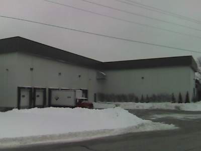
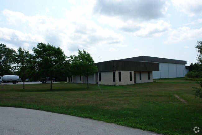
Property Record
2100 Sunset Dr, Plymouth, WI 53073

NEARBY LISTINGS FOR SALE OR LEASE
-
-
View all Plymouth listings for sale on LoopNet.com
Property Detail
2100 Sunset Dr
59271818517
TR 1 & TR 2 CSM V9 P 133 - PRT SW NW,SEC 16,COM AT W1/4 COR,SD SEC,TH N01 DEG 26'W 50'& N88 DEG 11'23 E 33'TO PNT OF BEG,TH N
Commercialacreage
Sheboygan
X
Wisconsin
55117C0188F
5.28 AC
2024
Outlying Sheboygan
2024
Milwaukee/Madison
010504
Sheboygan, WI
DEMOGRAPHICS near 2100 Sunset Dr
1 Mile
3 Mile
5 Mile
2024 Total Population
1,521
11,028
16,078
2029 Population
1,483
10,922
15,835
Pop Growth 2024-2029
(2.50%)
(0.96%)
(1.51%)
Average Age
45
44
45
2024 Total Households
651
4,790
6,696
HH Growth 2024-2029
(2.46%)
(0.96%)
(1.54%)
Median Household Inc
$80,208
$65,700
$71,249
Avg Household Size
2.30
2.20
2.30
2024 Avg HH Vehicles
2.00
2.00
2.00
Median Home Value
$235,091
$213,465
$236,649
Median Year Built
1973
1973
1973
Nearby Places
Map Layers
Map Styles
 Street
 Aerial
- Restaurants
- Banks
- Shops
- Fitness
- Groceries
Nearby Properties
Address
Land Use
TOTAL SIZE
Lot Size
Zoning
Address
Land Use
TOTAL SIZE
Lot Size
Zoning
62.93 AC
Address
Land Use
TOTAL SIZE
Lot Size
Zoning
44.12 AC
Address
Land Use
TOTAL SIZE
Lot Size
Zoning
31.71 AC
A1
Address
Land Use
TOTAL SIZE
Lot Size
Zoning
14.40 AC
Address
Land Use
TOTAL SIZE
Lot Size
Zoning
1.81 AC
Address
Land Use
TOTAL SIZE
Lot Size
Zoning
3.67 AC
Address
Land Use
TOTAL SIZE
Lot Size
Zoning
15.20 AC
Address
Land Use
TOTAL SIZE
Lot Size
Zoning
Address
Land Use
TOTAL SIZE
Lot Size
Zoning
3.15 AC
Address
Land Use
TOTAL SIZE
Lot Size
Zoning
Address
Land Use
TOTAL SIZE
Lot Size
Zoning
Address
Land Use
TOTAL SIZE
Lot Size
Zoning
3.21 AC
Address
Land Use
TOTAL SIZE
Lot Size
Zoning
Address
Land Use
TOTAL SIZE
Lot Size
Zoning
13.88 AC
M1
Address
Land Use
TOTAL SIZE
Lot Size
Zoning
6.21 AC
Address
Land Use
TOTAL SIZE
Lot Size
Zoning
1,836 SF
127.87 AC
P1
Address
Land Use
TOTAL SIZE
Lot Size
Zoning
1.89 AC
Address
Land Use
TOTAL SIZE
Lot Size
Zoning
1,156 SF
8.70 AC
SR5
Address
Land Use
TOTAL SIZE
Lot Size
Zoning
Address
Land Use
TOTAL SIZE
Lot Size
Zoning
1.50 AC
Address
Land Use
TOTAL SIZE
Lot Size
Zoning
3.54 AC
Address
Land Use
TOTAL SIZE
Lot Size
Zoning
Address
Land Use
TOTAL SIZE
Lot Size
Zoning
3.13 AC
Address
Land Use
TOTAL SIZE
Lot Size
Zoning
2.34 AC
Address
Land Use
TOTAL SIZE
Lot Size
Zoning
1.93 AC
Address
Land Use
TOTAL SIZE
Lot Size
Zoning
2.16 AC
Address
Land Use
TOTAL SIZE
Lot Size
Zoning
0.79 AC
Address
Land Use
TOTAL SIZE
Lot Size
Zoning
7.86 AC
B2
Address
Land Use
TOTAL SIZE
Lot Size
Zoning
0.88 AC
R1
The World's #1 Commercial Real Estate Marketplace
Connect with us
© 2026 CoStar Group
The information above has been obtained from sources believed reliable. While we do not doubt its accuracy we have not verified it and make no guarantee, warranty or representation about it. It is your responsibility to independently confirm its accuracy and completeness. Any projections, opinions, assumptions, or estimates used are for example only and do not represent the current or future performance of the property. The value of this transaction to you depends on tax and other factors which should be evaluated by your tax, financial, and legal advisors. You and your advisors should conduct a careful, independent investigation of the property to determine to your satisfaction the suitability of the property for your needs.