Property Record
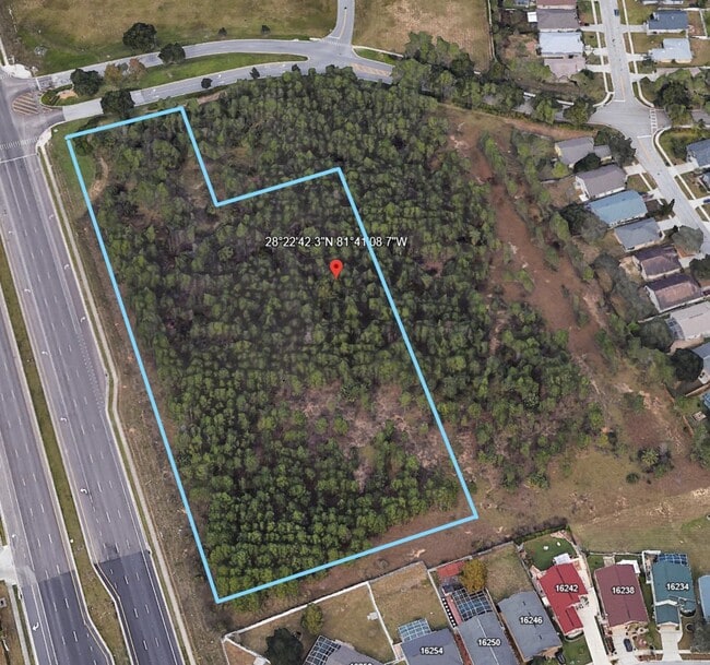
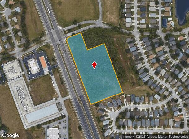
2100 Us Highway 27 Blvd, Clermont, FL 34714

NEARBY LISTINGS FOR SALE OR LEASE
Property Detail
2100 Us Highway 27 Blvd
Orlando-Kissimmee-Sanford, FL
None
23-24-26-0003-000-01300
FROM THE NORTHWEEST CORNER OF THE SOUTH 3/4 OF THE EAST 1/2 OF THE SOUTHWEST 1/4 OF SECTION 23-24-26 RUN NORTH 87-55-44 EAST ALONG THE NORTH LINE OF THE SOUTH 3/4 OF THE EAST 1/2 OF THE SOUTHWEST 1/4 A DISTANCE OF 297.24 FEET SOUTH 02-08-36 EAST 652.
Commercialacreage
Lake
X
Florida
12069C0675E
13
2024
4.10 AC
2026
Lake County
031324
Orlando
DEMOGRAPHICS near 2100 Us Highway 27 Blvd
1 Mile
3 Mile
5 Mile
2024 Total Population
9,553
35,279
78,608
2029 Population
11,403
42,271
93,975
Pop Growth 2024-2029
+ 19.37%
+ 19.82%
+ 19.55%
Average Age
37
39
37
2024 Total Households
3,147
13,327
28,766
HH Growth 2024-2029
+ 19.19%
+ 19.46%
+ 19.53%
Median Household Inc
$71,310
$67,942
$68,053
Avg Household Size
2.90
2.60
2.70
2024 Avg HH Vehicles
2.00
2.00
2.00
Median Home Value
$265,438
$290,604
$299,897
Median Year Built
1998
2004
2008
Nearby Places
Map Layers
Map Styles
 Street
 Aerial
- Restaurants
- Banks
- Shops
- Fitness
- Groceries
PUBLIC TRANSPORTATION
AIRPORT
Orlando International
DRIVE
WALK
Distance
Orlando International
45 min
30.7 mi
Freight Ports
Port of Tampa Bay
DRIVE
WALK
Distance
Port of Tampa Bay
81 min
66.9 mi
Nearby Properties
Address
Land Use
TOTAL SIZE
Lot Size
Zoning
Address
Land Use
TOTAL SIZE
Lot Size
Zoning
414,620 SF
16.64 AC
P-D
Address
Land Use
TOTAL SIZE
Lot Size
Zoning
489,411 SF
19.04 AC
Address
Land Use
TOTAL SIZE
Lot Size
Zoning
128,000 SF
19.60 AC
P-D
Address
Land Use
TOTAL SIZE
Lot Size
Zoning
381,117 SF
10.72 AC
Address
Land Use
TOTAL SIZE
Lot Size
Zoning
306,139 SF
19.77 AC
P-D
Address
Land Use
TOTAL SIZE
Lot Size
Zoning
333,280 SF
14.73 AC
Address
Land Use
TOTAL SIZE
Lot Size
Zoning
353,423 SF
16.51 AC
PUD
Address
Land Use
TOTAL SIZE
Lot Size
Zoning
316,273 SF
12.24 AC
Address
Land Use
TOTAL SIZE
Lot Size
Zoning
357,292 SF
1.34 AC
P-D
Address
Land Use
TOTAL SIZE
Lot Size
Zoning
277,616 SF
19.03 AC
Address
Land Use
TOTAL SIZE
Lot Size
Zoning
330,913 SF
16.74 AC
PUD
Address
Land Use
TOTAL SIZE
Lot Size
Zoning
375,326 SF
20.03 AC
PUD
Address
Land Use
TOTAL SIZE
Lot Size
Zoning
157,229 SF
25 AC
P-D
Address
Land Use
TOTAL SIZE
Lot Size
Zoning
272,106 SF
12.22 AC
Address
Land Use
TOTAL SIZE
Lot Size
Zoning
315,346 SF
22.69 AC
PUD
Address
Land Use
TOTAL SIZE
Lot Size
Zoning
299,696 SF
9.79 AC
PUD
Address
Land Use
TOTAL SIZE
Lot Size
Zoning
283,492 SF
11.97 AC
PUD
Address
Land Use
TOTAL SIZE
Lot Size
Zoning
189.88 AC
P-D
Address
Land Use
TOTAL SIZE
Lot Size
Zoning
196,553 SF
6.13 AC
Address
Land Use
TOTAL SIZE
Lot Size
Zoning
97.51 AC
P-D
Address
Land Use
TOTAL SIZE
Lot Size
Zoning
330,563 SF
20.07 AC
PUD
Address
Land Use
TOTAL SIZE
Lot Size
Zoning
93,017 SF
15.04 AC
P-D
Address
Land Use
TOTAL SIZE
Lot Size
Zoning
16,371 SF
266.28 AC
C1
Address
Land Use
TOTAL SIZE
Lot Size
Zoning
149,856 SF
4.66 AC
PUD
Address
Land Use
TOTAL SIZE
Lot Size
Zoning
38.50 AC
P-D
Address
Land Use
TOTAL SIZE
Lot Size
Zoning
24,465 SF
0.57 AC
P-D
Address
Land Use
TOTAL SIZE
Lot Size
Zoning
116,811 SF
3.94 AC
PUD
Address
Land Use
TOTAL SIZE
Lot Size
Zoning
135,091 SF
11.45 AC
PUD
Address
Land Use
TOTAL SIZE
Lot Size
Zoning
118,569 SF
3.53 AC
PUD
Address
Land Use
TOTAL SIZE
Lot Size
Zoning
236,248 SF
21.41 AC
PUD
The World's #1 Commercial Real Estate Marketplace
Connect with us
© 2026 CoStar Group
The information above has been obtained from sources believed reliable. While we do not doubt its accuracy we have not verified it and make no guarantee, warranty or representation about it. It is your responsibility to independently confirm its accuracy and completeness. Any projections, opinions, assumptions, or estimates used are for example only and do not represent the current or future performance of the property. The value of this transaction to you depends on tax and other factors which should be evaluated by your tax, financial, and legal advisors. You and your advisors should conduct a careful, independent investigation of the property to determine to your satisfaction the suitability of the property for your needs.