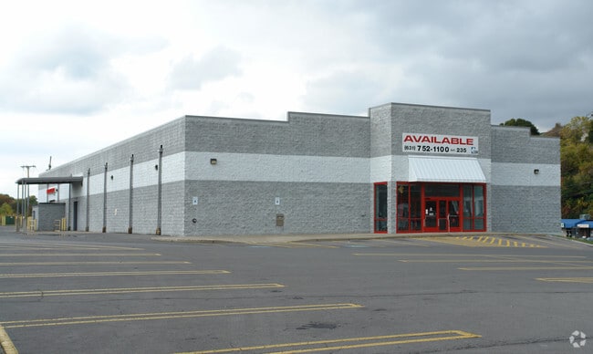
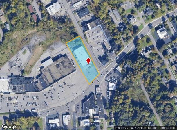
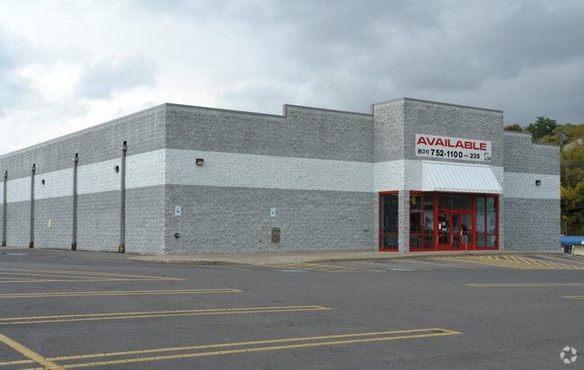
Property Record
2100 W Genesee St, Syracuse, NY 13219
NEARBY LISTINGS FOR SALE OR LEASE
Property Detail
2100 W Genesee St
313201-014-000-0006-008-003-0000
Onondaga
Storebuilding
New York
X
8.003
36067C0212F
1.50 AC
2025
W Outer Onondaga County
2024
Syracuse
013000
Syracuse, NY
18,700 SF
DEMOGRAPHICS near 2100 W Genesee St
1 Mile
3 Mile
5 Mile
2024 Total Population
12,010
90,440
216,861
2029 Population
11,584
88,681
212,002
Pop Growth 2024-2029
(3.55%)
(1.94%)
(2.24%)
Average Age
40
38
39
2024 Total Households
5,484
38,259
89,228
HH Growth 2024-2029
(3.74%)
(1.88%)
(2.34%)
Median Household Inc
$55,498
$47,118
$51,275
Avg Household Size
2.10
2.20
2.20
2024 Avg HH Vehicles
1.00
1.00
1.00
Median Home Value
$141,333
$142,538
$146,767
Median Year Built
1948
1951
1954
Nearby Places
- Restaurants
- Banks
- Shops
- Fitness
- Groceries
PUBLIC TRANSPORTATION
COMMUTER RAIL
Syracuse Regional Transportation Center (Empire Service - Amtrak, Lake Shore Limited - Amtrak, Maple Leaf - Amtrak)
DRIVE
WALK
Distance
Syracuse Regional Transportation Center (Empire Service - Amtrak, Lake Shore Limited - Amtrak, Maple Leaf - Amtrak)
7 min
3.2 mi
Nyf (Empire Service - Amtrak, Maple Leaf - Amtrak)
DRIVE
WALK
Distance
Nyf (Empire Service - Amtrak, Maple Leaf - Amtrak)
6 min
3.5 mi
AIRPORT
Syracuse Hancock International
DRIVE
WALK
Distance
Syracuse Hancock International
14 min
7.8 mi
Freight Ports
Albany, NY Port
DRIVE
WALK
Distance
Albany, NY Port
178 min
147.1 mi
SALE & LEASE HISTORY
LISTING DATE
SALE/LEASE

Sep 25, 2016
For Lease
Mar 29, 2017
For Lease
Nearby Properties
Address
Land Use
TOTAL SIZE
Lot Size
Zoning
Address
Land Use
TOTAL SIZE
Lot Size
Zoning
847,042 SF
42.78 AC
23
Address
Land Use
TOTAL SIZE
Lot Size
Zoning
57,011 SF
22.53 AC
22
Address
Land Use
TOTAL SIZE
Lot Size
Zoning
508,658 SF
2.23 AC
25
Address
Land Use
TOTAL SIZE
Lot Size
Zoning
848,000 SF
30.29 AC
Address
Land Use
TOTAL SIZE
Lot Size
Zoning
826,528 SF
2.28 AC
06 - INDUS
Address
Land Use
TOTAL SIZE
Lot Size
Zoning
269,030 SF
11.90 AC
05 - COMME
Address
Land Use
TOTAL SIZE
Lot Size
Zoning
72,200 SF
12.39 AC
06 - INDUS
Address
Land Use
TOTAL SIZE
Lot Size
Zoning
522,469 SF
1.87 AC
14
Address
Land Use
TOTAL SIZE
Lot Size
Zoning
6,598 SF
4.09 AC
14
Address
Land Use
TOTAL SIZE
Lot Size
Zoning
108,368 SF
3.36 AC
14
Address
Land Use
TOTAL SIZE
Lot Size
Zoning
653,177 SF
1.94 AC
13
Address
Land Use
TOTAL SIZE
Lot Size
Zoning
224,736 SF
2.48 AC
10
Address
Land Use
TOTAL SIZE
Lot Size
Zoning
316,848 SF
10.72 AC
08 - GOVER
Address
Land Use
TOTAL SIZE
Lot Size
Zoning
13,800 SF
2.10 AC
16
Address
Land Use
TOTAL SIZE
Lot Size
Zoning
275,732 SF
2.91 AC
13
Address
Land Use
TOTAL SIZE
Lot Size
Zoning
296,703 SF
1.48 AC
25
Address
Land Use
TOTAL SIZE
Lot Size
Zoning
307,860 SF
1.17 AC
25
Address
Land Use
TOTAL SIZE
Lot Size
Zoning
5,837 SF
1.26 AC
15
Address
Land Use
TOTAL SIZE
Lot Size
Zoning
31,947 SF
1.23 AC
Address
Land Use
TOTAL SIZE
Lot Size
Zoning
172,600 SF
3.19 AC
06 - INDUS
Address
Land Use
TOTAL SIZE
Lot Size
Zoning
367,508 SF
0.48 AC
12
Address
Land Use
TOTAL SIZE
Lot Size
Zoning
74,700 SF
3.64 AC
25
Address
Land Use
TOTAL SIZE
Lot Size
Zoning
256,704 SF
3.77 AC
07 - MIXED
Address
Land Use
TOTAL SIZE
Lot Size
Zoning
23,650 SF
146.50 AC
06 - INDUS
Address
Land Use
TOTAL SIZE
Lot Size
Zoning
329,212 SF
2.11 AC
12
Address
Land Use
TOTAL SIZE
Lot Size
Zoning
79,344 SF
1.65 AC
14
Address
Land Use
TOTAL SIZE
Lot Size
Zoning
410,021 SF
2.22 AC
05 - COMME
Address
Land Use
TOTAL SIZE
Lot Size
Zoning
150,056 SF
48.64 AC
07 - MIXED
Address
Land Use
TOTAL SIZE
Lot Size
Zoning
23,212 SF
3.39 AC
22
Address
Land Use
TOTAL SIZE
Lot Size
Zoning
37,045 SF
5.58 AC
06 - INDUS
The World's #1 Commercial Real Estate Marketplace
Connect with us
© 2025 CoStar Group
The information above has been obtained from sources believed reliable. While we do not doubt its accuracy we have not verified it and make no guarantee, warranty or representation about it. It is your responsibility to independently confirm its accuracy and completeness. Any projections, opinions, assumptions, or estimates used are for example only and do not represent the current or future performance of the property. The value of this transaction to you depends on tax and other factors which should be evaluated by your tax, financial, and legal advisors. You and your advisors should conduct a careful, independent investigation of the property to determine to your satisfaction the suitability of the property for your needs.