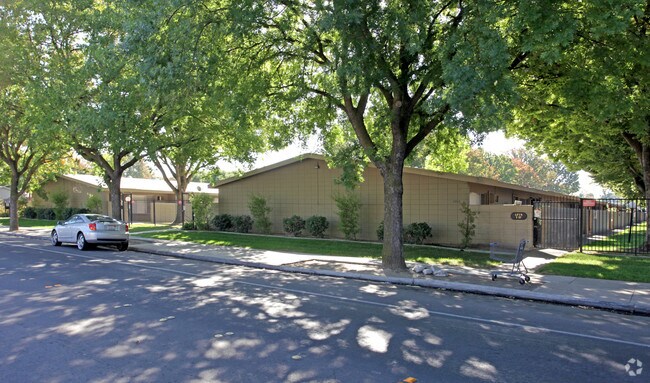
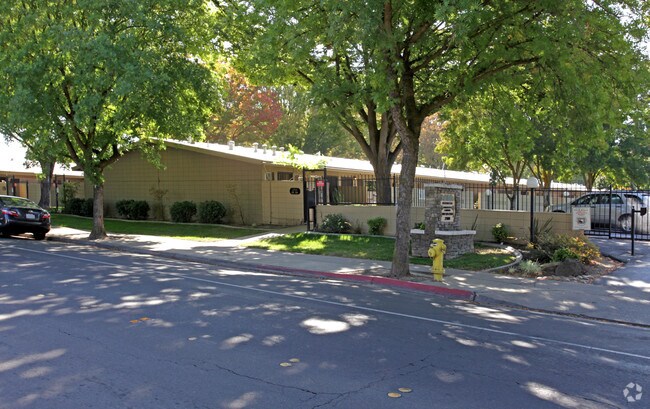
Property Record
2100 Wylie Dr, Modesto, CA 95355
Save to a Folder
{{folder.Name}}
{{folder.ListingIds.length}} Properties
{{folder.ListingIds.length}} Property
Create a New Folder
Property Detail
2100 Wylie Dr
032-32-18
Stanislaus
Apartmenthouse5plusunits
California
B and X Area of moderate flood hazard, usually the area between the limits of the 100-year and 500-year floods.
b
2025
5.30 AC
2025
Northeast Modesto
001001
Stockton/Modesto
70,035 SF
Modesto, CA
NEARBY LISTINGS FOR SALE OR LEASE
-
-
View all Modesto listings for sale on LoopNet.com
DEMOGRAPHICS near 2100 Wylie Dr
1 mile
3 mile
5 mile
2025 Total Population
17,947
141,465
298,136
2030 Population
18,005
142,253
299,827
Pop Growth 2025-2030
+ 0.32%
+ 0.56%
+ 0.57%
Average Age
40
39
37
2025 Total Households
6,769
49,630
95,713
HH Growth 2025-2030
+ 0.35%
+ 0.56%
+ 0.57%
Median Household Inc
$82,574
$83,257
$81,011
Avg Household Size
2.60
2.80
3.00
2025 Avg HH Vehicles
2.00
2.00
2.00
Median Home Value
$445,097
$453,046
$444,017
Median Year Built
1973
1975
1977
Nearby Places
Map Layers
Map Styles
 Street
 Aerial
Layers
 Traffic
 Biking
Places
Listings with unknown addresses are not visible on the map
- Restaurants
- Banks
- Shops
- Fitness
- Groceries
PUBLIC TRANSPORTATION
AIRPORT
Stockton Metro
Drive
Walk
Distance
Stockton Metro
38 min
27.1 mi
Freight Ports
Port of Stockton
Drive
Walk
Distance
Port of Stockton
47 min
35.6 mi
Nearby Properties
Address
Land Use
TOTAL SIZE
Lot Size
Zoning
Address
Land Use
TOTAL SIZE
Lot Size
Zoning
517,008 SF
71.35 AC
Address
Land Use
TOTAL SIZE
Lot Size
Zoning
817,526 SF
17.31 AC
Address
Land Use
TOTAL SIZE
Lot Size
Zoning
766,000 SF
22.69 AC
MODPD
Address
Land Use
TOTAL SIZE
Lot Size
Zoning
373,574 SF
23 AC
Address
Land Use
TOTAL SIZE
Lot Size
Zoning
450,277 SF
15.29 AC
Address
Land Use
TOTAL SIZE
Lot Size
Zoning
308,903 SF
13.21 AC
Address
Land Use
TOTAL SIZE
Lot Size
Zoning
448,549 SF
58.48 AC
Address
Land Use
TOTAL SIZE
Lot Size
Zoning
153,937 SF
7.87 AC
Address
Land Use
TOTAL SIZE
Lot Size
Zoning
151,288 SF
6.50 AC
Address
Land Use
TOTAL SIZE
Lot Size
Zoning
138,618 SF
3.99 AC
Address
Land Use
TOTAL SIZE
Lot Size
Zoning
77,382 SF
2.60 AC
Address
Land Use
TOTAL SIZE
Lot Size
Zoning
1,225,202 SF
67.24 AC
MI
Address
Land Use
TOTAL SIZE
Lot Size
Zoning
154,264 SF
7.63 AC
Address
Land Use
TOTAL SIZE
Lot Size
Zoning
224,940 SF
9.40 AC
MODSP
Address
Land Use
TOTAL SIZE
Lot Size
Zoning
266,975 SF
1.90 AC
Address
Land Use
TOTAL SIZE
Lot Size
Zoning
192,858 SF
10.44 AC
Address
Land Use
TOTAL SIZE
Lot Size
Zoning
131,958 SF
8.11 AC
Address
Land Use
TOTAL SIZE
Lot Size
Zoning
775,280 SF
30.42 AC
COUM
Address
Land Use
TOTAL SIZE
Lot Size
Zoning
231,178 SF
10.04 AC
R3
Address
Land Use
TOTAL SIZE
Lot Size
Zoning
65,294 SF
4.20 AC
Address
Land Use
TOTAL SIZE
Lot Size
Zoning
120,383 SF
5.52 AC
MODCM
Address
Land Use
TOTAL SIZE
Lot Size
Zoning
476,580 SF
44.60 AC
Address
Land Use
TOTAL SIZE
Lot Size
Zoning
79,458 SF
5.32 AC
Address
Land Use
TOTAL SIZE
Lot Size
Zoning
280,223 SF
23.52 AC
MODC2
Address
Land Use
TOTAL SIZE
Lot Size
Zoning
120,160 SF
6 AC
MODPD
Address
Land Use
TOTAL SIZE
Lot Size
Zoning
164,740 SF
9.35 AC
Address
Land Use
TOTAL SIZE
Lot Size
Zoning
118,800 SF
0.64 AC
Address
Land Use
TOTAL SIZE
Lot Size
Zoning
233,787 SF
14.65 AC
Address
Land Use
TOTAL SIZE
Lot Size
Zoning
98,140 SF
6.04 AC
Address
Land Use
TOTAL SIZE
Lot Size
Zoning
119,046 SF
8.94 AC
The World's #1 Commercial Real Estate Marketplace
Connect with us
© 2026 CoStar Group
The information above has been obtained from sources believed reliable. While we do not doubt its accuracy we have not verified it and make no guarantee, warranty or representation about it. It is your responsibility to independently confirm its accuracy and completeness. Any projections, opinions, assumptions, or estimates used are for example only and do not represent the current or future performance of the property. The value of this transaction to you depends on tax and other factors which should be evaluated by your tax, financial, and legal advisors. You and your advisors should conduct a careful, independent investigation of the property to determine to your satisfaction the suitability of the property for your needs.