Property Record
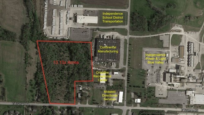
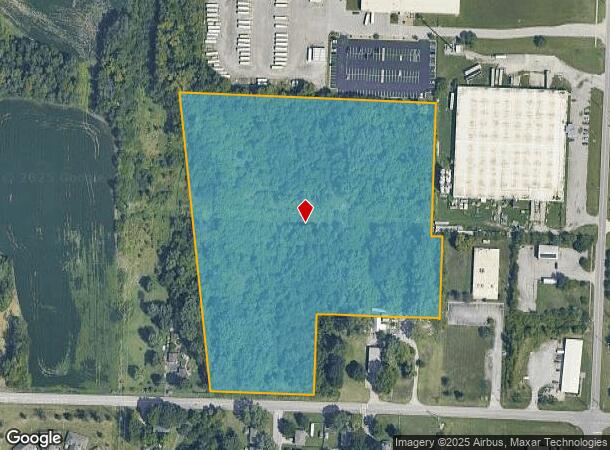
21000 E Truman Rd, Independence, MO 64056
NEARBY LISTINGS FOR SALE OR LEASE
Property Detail
21000 E Truman Rd
Kansas City, MO-KS
Phoebe H Powell Farm
25-110-01-12-00-0-00-000
PHOEBE H POWELL FARM ALL TH PT OF LOTS 3-5 DAF: BEG 855 W & 40 N OF SE COR OF NE 1/4 TH N 87 DEG W 314.06 TO W LI SD SUB TH N 6 DEG W 896.50 TO NW COR SD SUB TH S 87 DEG E 790
Commercialacreage
Jackson
X
Missouri
29095C0304G
3-5
2024
13.15 AC
2025
East Jackson County
011406
Kansas City
DEMOGRAPHICS near 21000 E Truman Rd
1 Mile
3 Mile
5 Mile
2024 Total Population
1,913
29,561
89,558
2029 Population
1,886
29,181
88,506
Pop Growth 2024-2029
(1.41%)
(1.29%)
(1.17%)
Average Age
40
40
41
2024 Total Households
716
11,243
35,928
HH Growth 2024-2029
(1.54%)
(1.41%)
(1.27%)
Median Household Inc
$70,166
$70,479
$66,210
Avg Household Size
2.60
2.50
2.40
2024 Avg HH Vehicles
2.00
2.00
2.00
Median Home Value
$228,947
$199,873
$186,215
Median Year Built
1999
1977
1975
Nearby Places
Map Layers
Map Styles
 Street
 Aerial
- Restaurants
- Banks
- Shops
- Fitness
- Groceries
PUBLIC TRANSPORTATION
COMMUTER RAIL
Independence Amtrak Station (Lincoln Service Missouri River Runner - Amtrak, Missouri River Runner - Amtrak)
DRIVE
WALK
Distance
Independence Amtrak Station (Lincoln Service Missouri River Runner - Amtrak, Missouri River Runner - Amtrak)
13 min
5.9 mi
AIRPORT
Kansas City International
DRIVE
WALK
Distance
Kansas City International
48 min
33.0 mi
Freight Ports
Tulsa Port Of Catoosa
DRIVE
WALK
Distance
Tulsa Port Of Catoosa
283 min
252.1 mi
Nearby Properties
Address
Land Use
TOTAL SIZE
Lot Size
Zoning
Address
Land Use
TOTAL SIZE
Lot Size
Zoning
250,196 SF
39.50 AC
Address
Land Use
TOTAL SIZE
Lot Size
Zoning
Address
Land Use
TOTAL SIZE
Lot Size
Zoning
287,132 SF
Address
Land Use
TOTAL SIZE
Lot Size
Zoning
193,191 SF
4.14 AC
Address
Land Use
TOTAL SIZE
Lot Size
Zoning
286,547 SF
Address
Land Use
TOTAL SIZE
Lot Size
Zoning
60,949 SF
16.90 AC
Address
Land Use
TOTAL SIZE
Lot Size
Zoning
157,429 SF
36.60 AC
Address
Land Use
TOTAL SIZE
Lot Size
Zoning
56,664 SF
Address
Land Use
TOTAL SIZE
Lot Size
Zoning
111,445 SF
8 AC
Address
Land Use
TOTAL SIZE
Lot Size
Zoning
24,225 SF
Address
Land Use
TOTAL SIZE
Lot Size
Zoning
45,870 SF
2.01 AC
Address
Land Use
TOTAL SIZE
Lot Size
Zoning
104,740 SF
7.25 AC
Address
Land Use
TOTAL SIZE
Lot Size
Zoning
158,109 SF
2.77 AC
Address
Land Use
TOTAL SIZE
Lot Size
Zoning
153,774 SF
Address
Land Use
TOTAL SIZE
Lot Size
Zoning
48,330 SF
12.31 AC
Address
Land Use
TOTAL SIZE
Lot Size
Zoning
246,652 SF
5.07 AC
Address
Land Use
TOTAL SIZE
Lot Size
Zoning
46,489 SF
2.07 AC
Address
Land Use
TOTAL SIZE
Lot Size
Zoning
152,806 SF
94.25 AC
Address
Land Use
TOTAL SIZE
Lot Size
Zoning
10,420 SF
2.74 AC
Address
Land Use
TOTAL SIZE
Lot Size
Zoning
47,978 SF
10.20 AC
Address
Land Use
TOTAL SIZE
Lot Size
Zoning
62,070 SF
5.35 AC
Address
Land Use
TOTAL SIZE
Lot Size
Zoning
65,349 SF
15.77 AC
Address
Land Use
TOTAL SIZE
Lot Size
Zoning
23,590 SF
2.30 AC
Address
Land Use
TOTAL SIZE
Lot Size
Zoning
15,015 SF
1.96 AC
Address
Land Use
TOTAL SIZE
Lot Size
Zoning
Address
Land Use
TOTAL SIZE
Lot Size
Zoning
5,169 SF
Address
Land Use
TOTAL SIZE
Lot Size
Zoning
53,566 SF
4.42 AC
Address
Land Use
TOTAL SIZE
Lot Size
Zoning
111,555 SF
5.54 AC
Address
Land Use
TOTAL SIZE
Lot Size
Zoning
54,411 SF
10.71 AC
Address
Land Use
TOTAL SIZE
Lot Size
Zoning
38,765 SF
7 AC
The World's #1 Commercial Real Estate Marketplace
Connect with us
© 2025 CoStar Group
The information above has been obtained from sources believed reliable. While we do not doubt its accuracy we have not verified it and make no guarantee, warranty or representation about it. It is your responsibility to independently confirm its accuracy and completeness. Any projections, opinions, assumptions, or estimates used are for example only and do not represent the current or future performance of the property. The value of this transaction to you depends on tax and other factors which should be evaluated by your tax, financial, and legal advisors. You and your advisors should conduct a careful, independent investigation of the property to determine to your satisfaction the suitability of the property for your needs.