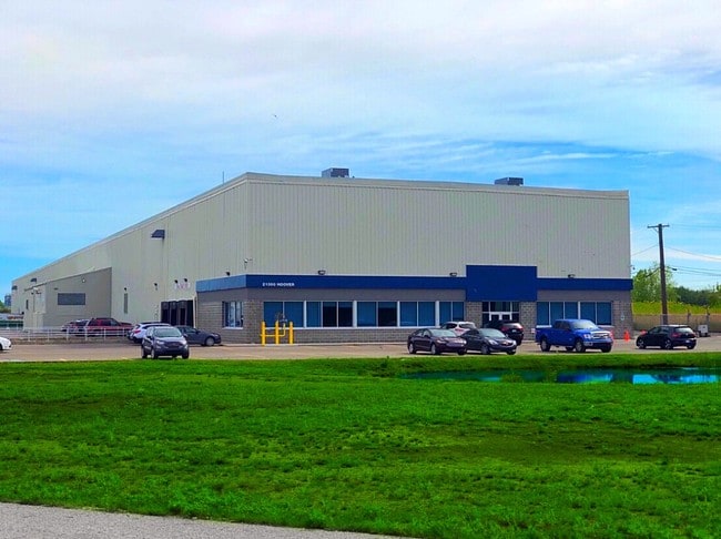
Property Record
21000 Hoover Rd, Warren, MI 48089


NEARBY LISTINGS FOR SALE OR LEASE
Property Detail
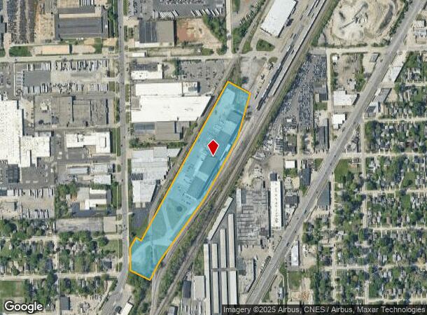
21000 Hoover Rd
12-13-35-302-006
T1N, R12E, SEC 35; COMM AT INTER OF NWLY ROW LINE GTWRR & W LINE SEC 35; TH N31*25'40"E 63.29 FT TO POB; TH N31*25'40"E
Lightindustrial
Macomb
X
Michigan
26163C0125E
10.75 AC
2025
Groesbeck South
2025
Detroit
268400
Detroit-Warren-Dearborn, MI
89,120 SF
DEMOGRAPHICS near 21000 Hoover Rd
1 Mile
3 Mile
5 Mile
2024 Total Population
12,577
140,330
399,178
2029 Population
12,641
140,886
397,420
Pop Growth 2024-2029
+ 0.51%
+ 0.40%
(0.44%)
Average Age
34
37
38
2024 Total Households
4,343
52,034
150,414
HH Growth 2024-2029
+ 0.46%
+ 0.29%
(0.45%)
Median Household Inc
$40,282
$42,754
$44,636
Avg Household Size
2.80
2.60
2.60
2024 Avg HH Vehicles
1.00
1.00
1.00
Median Home Value
$58,441
$80,183
$105,439
Median Year Built
1953
1954
1955
Nearby Places
Map Layers
Map Styles
 Street
 Aerial
- Restaurants
- Banks
- Shops
- Fitness
- Groceries
PUBLIC TRANSPORTATION
COMMUTER RAIL
DRIVE
WALK
Distance
19 min
9.0 mi
AIRPORT
Windsor International
DRIVE
WALK
Distance
Windsor International
45 min
20.4 mi
Detroit Metro Wayne County
DRIVE
WALK
Distance
Detroit Metro Wayne County
48 min
29.9 mi
SALE & LEASE HISTORY
LISTING DATE
SALE/LEASE

Oct 23, 2019
For Sale
Nov 16, 2016
For Lease
Mar 23, 2021
For Lease
Nearby Properties
Address
Land Use
TOTAL SIZE
Lot Size
Zoning
Address
Land Use
TOTAL SIZE
Lot Size
Zoning
260,164 SF
Address
Land Use
TOTAL SIZE
Lot Size
Zoning
419,600 SF
Address
Land Use
TOTAL SIZE
Lot Size
Zoning
3,327,621 SF
130.89 AC
M-4
Address
Land Use
TOTAL SIZE
Lot Size
Zoning
238,144 SF
12.15 AC
MZ
Address
Land Use
TOTAL SIZE
Lot Size
Zoning
450,958 SF
Address
Land Use
TOTAL SIZE
Lot Size
Zoning
661,151 SF
37.28 AC
MZ
Address
Land Use
TOTAL SIZE
Lot Size
Zoning
1,784,888 SF
58.32 AC
M-4
Address
Land Use
TOTAL SIZE
Lot Size
Zoning
323,858 SF
20.66 AC
R-3
Address
Land Use
TOTAL SIZE
Lot Size
Zoning
455,425 SF
Address
Land Use
TOTAL SIZE
Lot Size
Zoning
182,866 SF
5.08 AC
PD
Address
Land Use
TOTAL SIZE
Lot Size
Zoning
401,671 SF
19.40 AC
MZ
Address
Land Use
TOTAL SIZE
Lot Size
Zoning
198,064 SF
11.11 AC
MZ
Address
Land Use
TOTAL SIZE
Lot Size
Zoning
1,261,658 SF
71.94 AC
M-2
Address
Land Use
TOTAL SIZE
Lot Size
Zoning
362,350 SF
22.39 AC
M-2
Address
Land Use
TOTAL SIZE
Lot Size
Zoning
162,597 SF
17.94 AC
C-2
Address
Land Use
TOTAL SIZE
Lot Size
Zoning
Address
Land Use
TOTAL SIZE
Lot Size
Zoning
362,895 SF
14.85 AC
M-2
Address
Land Use
TOTAL SIZE
Lot Size
Zoning
1,094,075 SF
58.76 AC
M-4
Address
Land Use
TOTAL SIZE
Lot Size
Zoning
426,764 SF
38.46 AC
R-M
Address
Land Use
TOTAL SIZE
Lot Size
Zoning
197,670 SF
42.84 AC
M4
Address
Land Use
TOTAL SIZE
Lot Size
Zoning
166,064 SF
6.33 AC
M-3
Address
Land Use
TOTAL SIZE
Lot Size
Zoning
92,800 SF
6.71 AC
R-3
Address
Land Use
TOTAL SIZE
Lot Size
Zoning
105,354 SF
2.33 AC
B-3
Address
Land Use
TOTAL SIZE
Lot Size
Zoning
184,986 SF
13.49 AC
MZ
Address
Land Use
TOTAL SIZE
Lot Size
Zoning
410,359 SF
27.52 AC
M4
Address
Land Use
TOTAL SIZE
Lot Size
Zoning
81,072 SF
5.67 AC
M-4
Address
Land Use
TOTAL SIZE
Lot Size
Zoning
63,949 SF
10.41 AC
R-1-C
Address
Land Use
TOTAL SIZE
Lot Size
Zoning
180,834 SF
17.97 AC
M-3
Address
Land Use
TOTAL SIZE
Lot Size
Zoning
40,951 SF
42.61 AC
M-2
Address
Land Use
TOTAL SIZE
Lot Size
Zoning
251,056 SF
17.80 AC
MZ
The World's #1 Commercial Real Estate Marketplace
Connect with us
© 2025 CoStar Group
The information above has been obtained from sources believed reliable. While we do not doubt its accuracy we have not verified it and make no guarantee, warranty or representation about it. It is your responsibility to independently confirm its accuracy and completeness. Any projections, opinions, assumptions, or estimates used are for example only and do not represent the current or future performance of the property. The value of this transaction to you depends on tax and other factors which should be evaluated by your tax, financial, and legal advisors. You and your advisors should conduct a careful, independent investigation of the property to determine to your satisfaction the suitability of the property for your needs.